David Arango-Londoño , Delia Ortega-Lenis , Paula Moraga , Miyerlandi Torres , Francisco J. Rodríguez-Cortés
{"title":"Spatial modeling and socioeconomic inequities of COVID-19 in the urban area of the city of Cali, Colombia","authors":"David Arango-Londoño , Delia Ortega-Lenis , Paula Moraga , Miyerlandi Torres , Francisco J. Rodríguez-Cortés","doi":"10.1016/j.sste.2022.100561","DOIUrl":null,"url":null,"abstract":"<div><p>COVID-19 has spread worldwide with a high variability in cases and mortality between populations. This research aims to assess socioeconomic inequities of COVID-19 in the city of Cali, Colombia, during the first and second peaks of the pandemic in this city. An ecological study by neighborhoods was carried out, were COVID-19 cases were analyzed using a Bayesian hierarchical spatial model that includes potential risk factors such as the index of unsatisfied basic needs and socioeconomic variables as well as random effects to account for residual variation. Maps showing the geographic patterns of the estimated relative risks as well as exceedance probabilities were created. The results indicate that in the first wave, the neighborhoods with the greatest unsatisfied basic needs and low socioeconomic strata, were more likely to report positive cases for COVID-19. For the second wave, the disease begins to spread through different neighborhoods of the city and middle socioeconomic strata presents the highest risk followed by the lower strata. These findings indicate the importance of measuring social determinants in the study of the distribution of cases due to COVID-19 for its inclusion in the interventions and measures implemented to contain contagions and reduce impacts on the most vulnerable populations.</p></div>","PeriodicalId":46645,"journal":{"name":"Spatial and Spatio-Temporal Epidemiology","volume":"44 ","pages":"Article 100561"},"PeriodicalIF":1.7000,"publicationDate":"2023-02-01","publicationTypes":"Journal Article","fieldsOfStudy":null,"isOpenAccess":false,"openAccessPdf":"https://www.ncbi.nlm.nih.gov/pmc/articles/PMC9756648/pdf/","citationCount":"4","resultStr":null,"platform":"Semanticscholar","paperid":null,"PeriodicalName":"Spatial and Spatio-Temporal Epidemiology","FirstCategoryId":"1085","ListUrlMain":"https://www.sciencedirect.com/science/article/pii/S1877584522000843","RegionNum":0,"RegionCategory":null,"ArticlePicture":[],"TitleCN":null,"AbstractTextCN":null,"PMCID":null,"EPubDate":"2022/12/16 0:00:00","PubModel":"Epub","JCR":"Q3","JCRName":"PUBLIC, ENVIRONMENTAL & OCCUPATIONAL HEALTH","Score":null,"Total":0}
引用次数: 4
Abstract
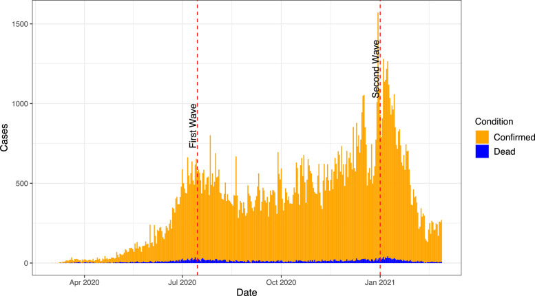
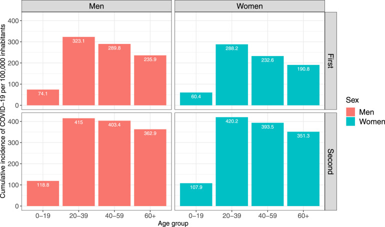
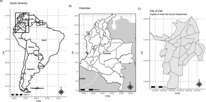
COVID-19 has spread worldwide with a high variability in cases and mortality between populations. This research aims to assess socioeconomic inequities of COVID-19 in the city of Cali, Colombia, during the first and second peaks of the pandemic in this city. An ecological study by neighborhoods was carried out, were COVID-19 cases were analyzed using a Bayesian hierarchical spatial model that includes potential risk factors such as the index of unsatisfied basic needs and socioeconomic variables as well as random effects to account for residual variation. Maps showing the geographic patterns of the estimated relative risks as well as exceedance probabilities were created. The results indicate that in the first wave, the neighborhoods with the greatest unsatisfied basic needs and low socioeconomic strata, were more likely to report positive cases for COVID-19. For the second wave, the disease begins to spread through different neighborhoods of the city and middle socioeconomic strata presents the highest risk followed by the lower strata. These findings indicate the importance of measuring social determinants in the study of the distribution of cases due to COVID-19 for its inclusion in the interventions and measures implemented to contain contagions and reduce impacts on the most vulnerable populations.


 分享
分享
 求助内容:
求助内容: 应助结果提醒方式:
 扫码关注我们
