Yulan Chen , Jianjun Li , Juying Jiao , Leichao Bai , Nan Wang , Tongde Chen , Ziqi Zhang , Qian Xu , Jianqiao Han
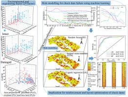
{"title":"Assessing the risk of check dam failure due to heavy rainfall using machine learning on the Loess Plateau, China","authors":"Yulan Chen , Jianjun Li , Juying Jiao , Leichao Bai , Nan Wang , Tongde Chen , Ziqi Zhang , Qian Xu , Jianqiao Han","doi":"10.1016/j.iswcr.2023.09.010","DOIUrl":null,"url":null,"abstract":"<div><p>Check dams are widely used throughout the world to tackle soil and water loss. However, the frequency of extreme rainfall events has increased owing to global climate change and the main structure of check dam is gradually aging, which lead to an increase in the failure risk of check dams. Thus, it is necessary to carry out the study on failure risk diagnosis and assessment of check dams. In the study, machine learning algorithms (ML), including random forests (RF), support vector machine (SVM), and logistic regression (LR), were used to integrate the environmental and engineering factors and then assess the risk of check dam failure due to the “7.26” rainstorm on July 26, 2017, in the Chabagou watershed, located in the hilly-gully region of the Loess Plateau, China. To verify the generalizability of the model in this study, these models were used for the Wangmaogou catchment north of the Loess Plateau. The accuracy assessment by the receiver operating characteristic (ROC) curve indicated that the RF model with an area under the ROC curve (AUC) greater than 0.89 was the most precise model and had a higher generalization ability. In addition, the model dataset was relatively small and easy to obtain, which make the risk modeling of check dam failure in the study has the potential for application in other regions. In the RF model, each factor selected was confirmed to be important, and the importance values for engineering factors were generally higher than those for the environmental factors. The risk map of check dam failure in the RF model indicated that 56.34% of check dams in the study area had very high and high risks of dam failure under high-intensity rainfall in 2017. Based on the importance of factors and the risk map of check dam failure, the prevention and control measures for reducing the risk of check dam failure and promoting the construction of check dam are proposed. These proposals provide a scientific basis for the reinforcement of check dams and the future layout of check dams in the Chinese Loess Plateau.</p></div>","PeriodicalId":48622,"journal":{"name":"International Soil and Water Conservation Research","volume":"12 3","pages":"Pages 506-520"},"PeriodicalIF":7.3000,"publicationDate":"2023-10-13","publicationTypes":"Journal Article","fieldsOfStudy":null,"isOpenAccess":false,"openAccessPdf":"https://www.sciencedirect.com/science/article/pii/S2095633923000928/pdfft?md5=554627811087e221143f6b3870c575f5&pid=1-s2.0-S2095633923000928-main.pdf","citationCount":"0","resultStr":null,"platform":"Semanticscholar","paperid":null,"PeriodicalName":"International Soil and Water Conservation Research","FirstCategoryId":"93","ListUrlMain":"https://www.sciencedirect.com/science/article/pii/S2095633923000928","RegionNum":1,"RegionCategory":"农林科学","ArticlePicture":[],"TitleCN":null,"AbstractTextCN":null,"PMCID":null,"EPubDate":"","PubModel":"","JCR":"Q1","JCRName":"ENVIRONMENTAL SCIENCES","Score":null,"Total":0}
引用次数: 0
Abstract
Check dams are widely used throughout the world to tackle soil and water loss. However, the frequency of extreme rainfall events has increased owing to global climate change and the main structure of check dam is gradually aging, which lead to an increase in the failure risk of check dams. Thus, it is necessary to carry out the study on failure risk diagnosis and assessment of check dams. In the study, machine learning algorithms (ML), including random forests (RF), support vector machine (SVM), and logistic regression (LR), were used to integrate the environmental and engineering factors and then assess the risk of check dam failure due to the “7.26” rainstorm on July 26, 2017, in the Chabagou watershed, located in the hilly-gully region of the Loess Plateau, China. To verify the generalizability of the model in this study, these models were used for the Wangmaogou catchment north of the Loess Plateau. The accuracy assessment by the receiver operating characteristic (ROC) curve indicated that the RF model with an area under the ROC curve (AUC) greater than 0.89 was the most precise model and had a higher generalization ability. In addition, the model dataset was relatively small and easy to obtain, which make the risk modeling of check dam failure in the study has the potential for application in other regions. In the RF model, each factor selected was confirmed to be important, and the importance values for engineering factors were generally higher than those for the environmental factors. The risk map of check dam failure in the RF model indicated that 56.34% of check dams in the study area had very high and high risks of dam failure under high-intensity rainfall in 2017. Based on the importance of factors and the risk map of check dam failure, the prevention and control measures for reducing the risk of check dam failure and promoting the construction of check dam are proposed. These proposals provide a scientific basis for the reinforcement of check dams and the future layout of check dams in the Chinese Loess Plateau.
期刊介绍:
The International Soil and Water Conservation Research (ISWCR), the official journal of World Association of Soil and Water Conservation (WASWAC) http://www.waswac.org, is a multidisciplinary journal of soil and water conservation research, practice, policy, and perspectives. It aims to disseminate new knowledge and promote the practice of soil and water conservation.
The scope of International Soil and Water Conservation Research includes research, strategies, and technologies for prediction, prevention, and protection of soil and water resources. It deals with identification, characterization, and modeling; dynamic monitoring and evaluation; assessment and management of conservation practice and creation and implementation of quality standards.
Examples of appropriate topical areas include (but are not limited to):
• Conservation models, tools, and technologies
• Conservation agricultural
• Soil health resources, indicators, assessment, and management
• Land degradation
• Sustainable development
• Soil erosion and its control
• Soil erosion processes
• Water resources assessment and management
• Watershed management
• Soil erosion models
• Literature review on topics related soil and water conservation research


 分享
分享
 求助内容:
求助内容: 应助结果提醒方式:
 扫码关注我们
