Sarah L. Greenwood, Rachael S. Avery, Richard Gyllencreutz, Carl Regnéll, Karol Tylmann
{"title":"Footprint of the Baltic Ice Stream: geomorphic evidence for shifting ice stream pathways","authors":"Sarah L. Greenwood, Rachael S. Avery, Richard Gyllencreutz, Carl Regnéll, Karol Tylmann","doi":"10.1111/bor.12634","DOIUrl":null,"url":null,"abstract":"<p>The Baltic Ice Stream, a large fast-flowing sector of the last Fennoscandian Ice Sheet that occupied the present-day Baltic Sea basin, was first conceptualized in the earliest days of glacial geological research in Scandinavia. Landform and sedimentological evidence from the terrestrial margins support the concept and numerical ice-sheet models demonstrate its existence and possible evolution. However, with evidence for the Baltic Ice Stream thus far limited to the terrestrial periphery, its true form, scale, function, and role in deglaciation have proven enigmatic. Here we present geomorphological evidence directly from the Baltic seabed that confirms the existence of and sheds light on the behaviour of the Baltic Ice Stream. Based on an extensive collection of high-, moderate- and low-resolution bathymetric terrain models covering a large proportion of the Baltic Sea floor, and complemented by LiDAR-data for the Baltic islands, we have identified and mapped >20 000 individual subglacial bedforms, meltwater landforms and grounding line landforms. We reconstruct a six-stage sequence of ice flow and retreat, finding that streaming was persistent in the Baltic but that pathways were variable in extent, timing and duration: different sectors of the Baltic exhibit asynchronous streaming and out-of-phase grounding line changes. During deglaciation, grounding line re-advances occurred in both the southwestern and the northern Baltic Proper, and, while abundant iceberg ploughmarks attest to calving as a significant ice loss mechanism, lobate margins suggest supply to the Baltic catchment was consistently high. Our reconstruction is limited by a fragmentary geomorphic record. Here we put forward a first hypothesis for how the Baltic Ice Stream evolved, and hope it stimulates new geomorphic, stratigraphical and core data collection to extend the landform record, provide insights into subglacial and grounding line processes, and constrain the chronology for Baltic Ice Stream flow and retreat.</p>","PeriodicalId":9184,"journal":{"name":"Boreas","volume":"53 1","pages":"4-26"},"PeriodicalIF":2.9000,"publicationDate":"2023-10-13","publicationTypes":"Journal Article","fieldsOfStudy":null,"isOpenAccess":false,"openAccessPdf":"https://onlinelibrary.wiley.com/doi/epdf/10.1111/bor.12634","citationCount":"0","resultStr":null,"platform":"Semanticscholar","paperid":null,"PeriodicalName":"Boreas","FirstCategoryId":"89","ListUrlMain":"https://onlinelibrary.wiley.com/doi/10.1111/bor.12634","RegionNum":3,"RegionCategory":"地球科学","ArticlePicture":[],"TitleCN":null,"AbstractTextCN":null,"PMCID":null,"EPubDate":"","PubModel":"","JCR":"Q2","JCRName":"GEOGRAPHY, PHYSICAL","Score":null,"Total":0}
引用次数: 0
Abstract
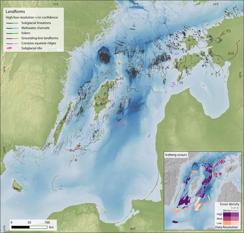
The Baltic Ice Stream, a large fast-flowing sector of the last Fennoscandian Ice Sheet that occupied the present-day Baltic Sea basin, was first conceptualized in the earliest days of glacial geological research in Scandinavia. Landform and sedimentological evidence from the terrestrial margins support the concept and numerical ice-sheet models demonstrate its existence and possible evolution. However, with evidence for the Baltic Ice Stream thus far limited to the terrestrial periphery, its true form, scale, function, and role in deglaciation have proven enigmatic. Here we present geomorphological evidence directly from the Baltic seabed that confirms the existence of and sheds light on the behaviour of the Baltic Ice Stream. Based on an extensive collection of high-, moderate- and low-resolution bathymetric terrain models covering a large proportion of the Baltic Sea floor, and complemented by LiDAR-data for the Baltic islands, we have identified and mapped >20 000 individual subglacial bedforms, meltwater landforms and grounding line landforms. We reconstruct a six-stage sequence of ice flow and retreat, finding that streaming was persistent in the Baltic but that pathways were variable in extent, timing and duration: different sectors of the Baltic exhibit asynchronous streaming and out-of-phase grounding line changes. During deglaciation, grounding line re-advances occurred in both the southwestern and the northern Baltic Proper, and, while abundant iceberg ploughmarks attest to calving as a significant ice loss mechanism, lobate margins suggest supply to the Baltic catchment was consistently high. Our reconstruction is limited by a fragmentary geomorphic record. Here we put forward a first hypothesis for how the Baltic Ice Stream evolved, and hope it stimulates new geomorphic, stratigraphical and core data collection to extend the landform record, provide insights into subglacial and grounding line processes, and constrain the chronology for Baltic Ice Stream flow and retreat.
期刊介绍:
Boreas has been published since 1972. Articles of wide international interest from all branches of Quaternary research are published. Biological as well as non-biological aspects of the Quaternary environment, in both glaciated and non-glaciated areas, are dealt with: Climate, shore displacement, glacial features, landforms, sediments, organisms and their habitat, and stratigraphical and chronological relationships.
Anticipated international interest, at least within a continent or a considerable part of it, is a main criterion for the acceptance of papers. Besides articles, short items like discussion contributions and book reviews are published.


 分享
分享
 求助内容:
求助内容: 应助结果提醒方式:
 扫码关注我们
