Birger Winkel, David Nakath, Felix Woelk, Kevin Köser
{"title":"Design, Implementation, and Evaluation of an External Pose-Tracking System for Underwater Cameras","authors":"Birger Winkel, David Nakath, Felix Woelk, Kevin Köser","doi":"10.1007/s41064-023-00263-x","DOIUrl":null,"url":null,"abstract":"Abstract To advance underwater computer vision and robotics from lab environments and clear water scenarios to the deep dark ocean or murky coastal waters, representative benchmarks and realistic datasets with ground truth information are required. In particular, determining the camera pose is essential for many underwater robotic or photogrammetric applications and known ground truth is mandatory to evaluate the performance of, e.g., simultaneous localization and mapping approaches in such extreme environments. This paper presents the conception, calibration, and implementation of an external reference system for determining the underwater camera pose in real time. The approach, based on an HTC Vive tracking system in air, calculates the underwater camera pose by fusing the poses of two controllers tracked above the water surface of a tank. It is shown that the mean deviation of this approach to an optical marker-based reference in air is less than 3 mm and 0.3 $$^{\\circ }$$ <mml:math xmlns:mml=\"http://www.w3.org/1998/Math/MathML\"> <mml:msup> <mml:mrow /> <mml:mo>∘</mml:mo> </mml:msup> </mml:math> . Finally, the usability of the system for underwater applications is demonstrated.","PeriodicalId":56035,"journal":{"name":"PFG-Journal of Photogrammetry Remote Sensing and Geoinformation Science","volume":"28 1","pages":"0"},"PeriodicalIF":3.3000,"publicationDate":"2023-10-16","publicationTypes":"Journal Article","fieldsOfStudy":null,"isOpenAccess":false,"openAccessPdf":"","citationCount":"0","resultStr":null,"platform":"Semanticscholar","paperid":null,"PeriodicalName":"PFG-Journal of Photogrammetry Remote Sensing and Geoinformation Science","FirstCategoryId":"1085","ListUrlMain":"https://doi.org/10.1007/s41064-023-00263-x","RegionNum":4,"RegionCategory":"地球科学","ArticlePicture":[],"TitleCN":null,"AbstractTextCN":null,"PMCID":null,"EPubDate":"","PubModel":"","JCR":"Q3","JCRName":"IMAGING SCIENCE & PHOTOGRAPHIC TECHNOLOGY","Score":null,"Total":0}
引用次数: 0
Abstract
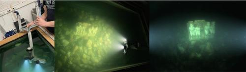
Abstract To advance underwater computer vision and robotics from lab environments and clear water scenarios to the deep dark ocean or murky coastal waters, representative benchmarks and realistic datasets with ground truth information are required. In particular, determining the camera pose is essential for many underwater robotic or photogrammetric applications and known ground truth is mandatory to evaluate the performance of, e.g., simultaneous localization and mapping approaches in such extreme environments. This paper presents the conception, calibration, and implementation of an external reference system for determining the underwater camera pose in real time. The approach, based on an HTC Vive tracking system in air, calculates the underwater camera pose by fusing the poses of two controllers tracked above the water surface of a tank. It is shown that the mean deviation of this approach to an optical marker-based reference in air is less than 3 mm and 0.3 $$^{\circ }$$ ∘ . Finally, the usability of the system for underwater applications is demonstrated.
期刊介绍:
PFG is an international scholarly journal covering the progress and application of photogrammetric methods, remote sensing technology and the interconnected field of geoinformation science. It places special editorial emphasis on the communication of new methodologies in data acquisition and new approaches to optimized processing and interpretation of all types of data which were acquired by photogrammetric methods, remote sensing, image processing and the computer-aided interpretation of such data in general. The journal hence addresses both researchers and students of these disciplines at academic institutions and universities as well as the downstream users in both the private sector and public administration.
Founded in 1926 under the former name Bildmessung und Luftbildwesen, PFG is worldwide the oldest journal on photogrammetry. It is the official journal of the German Society for Photogrammetry, Remote Sensing and Geoinformation (DGPF).


 分享
分享
 求助内容:
求助内容: 应助结果提醒方式:
 扫码关注我们
