{"title":"Human-network regions as effective geographic units for disease mitigation","authors":"Clio Andris, Caglar Koylu, Mason A. Porter","doi":"10.1140/epjds/s13688-023-00426-1","DOIUrl":null,"url":null,"abstract":"<p>Susceptibility to infectious diseases such as COVID-19 depends on how those diseases spread. Many studies have examined the decrease in COVID-19 spread due to reduction in travel. However, less is known about how much functional geographic regions, which capture natural movements and social interactions, limit the spread of COVID-19. To determine boundaries between functional regions, we apply community-detection algorithms to large networks of mobility and social-media connections to construct geographic regions that reflect natural human movement and relationships at the county level in the coterminous United States. We measure COVID-19 case counts, case rates, and case-rate variations across adjacent counties and examine how often COVID-19 crosses the boundaries of these functional regions. We find that regions that we construct using GPS-trace networks and especially commute networks have the lowest COVID-19 case rates along the boundaries, so these regions may reflect natural partitions in COVID-19 transmission. Conversely, regions that we construct from geolocated Facebook friendships and Twitter connections yield less effective partitions. Our analysis reveals that regions that are derived from movement flows are more appropriate geographic units than states for making policy decisions about opening areas for activity, assessing vulnerability of populations, and allocating resources. Our insights are also relevant for policy decisions and public messaging in future emergency situations.</p>","PeriodicalId":11887,"journal":{"name":"EPJ Data Science","volume":"36 1","pages":""},"PeriodicalIF":2.5000,"publicationDate":"2023-12-18","publicationTypes":"Journal Article","fieldsOfStudy":null,"isOpenAccess":false,"openAccessPdf":"","citationCount":"0","resultStr":null,"platform":"Semanticscholar","paperid":null,"PeriodicalName":"EPJ Data Science","FirstCategoryId":"94","ListUrlMain":"https://doi.org/10.1140/epjds/s13688-023-00426-1","RegionNum":2,"RegionCategory":"计算机科学","ArticlePicture":[],"TitleCN":null,"AbstractTextCN":null,"PMCID":null,"EPubDate":"","PubModel":"","JCR":"Q1","JCRName":"MATHEMATICS, INTERDISCIPLINARY APPLICATIONS","Score":null,"Total":0}
引用次数: 0
Abstract
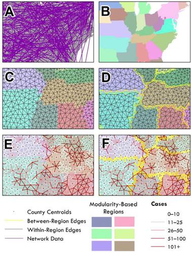
Susceptibility to infectious diseases such as COVID-19 depends on how those diseases spread. Many studies have examined the decrease in COVID-19 spread due to reduction in travel. However, less is known about how much functional geographic regions, which capture natural movements and social interactions, limit the spread of COVID-19. To determine boundaries between functional regions, we apply community-detection algorithms to large networks of mobility and social-media connections to construct geographic regions that reflect natural human movement and relationships at the county level in the coterminous United States. We measure COVID-19 case counts, case rates, and case-rate variations across adjacent counties and examine how often COVID-19 crosses the boundaries of these functional regions. We find that regions that we construct using GPS-trace networks and especially commute networks have the lowest COVID-19 case rates along the boundaries, so these regions may reflect natural partitions in COVID-19 transmission. Conversely, regions that we construct from geolocated Facebook friendships and Twitter connections yield less effective partitions. Our analysis reveals that regions that are derived from movement flows are more appropriate geographic units than states for making policy decisions about opening areas for activity, assessing vulnerability of populations, and allocating resources. Our insights are also relevant for policy decisions and public messaging in future emergency situations.
期刊介绍:
EPJ Data Science covers a broad range of research areas and applications and particularly encourages contributions from techno-socio-economic systems, where it comprises those research lines that now regard the digital “tracks” of human beings as first-order objects for scientific investigation. Topics include, but are not limited to, human behavior, social interaction (including animal societies), economic and financial systems, management and business networks, socio-technical infrastructure, health and environmental systems, the science of science, as well as general risk and crisis scenario forecasting up to and including policy advice.


 分享
分享
 求助内容:
求助内容: 应助结果提醒方式:
 扫码关注我们
