The Gulf of Mexico hosts some of the most productive fisheries in the United States, whereas the same region is known to experience environmental stressors, such as summer hypoxia. Ecosystem models have been developed for the Gulf of Mexico to determine how hypoxia affects living marine resources, but these models and their output are not always easy to access or interpret by managers, thereby decreasing their implementation in a management setting. To help alleviate the gap between ecosystem model development and management utility, the current study focuses on co-produced, user-friendly tools that describe the effects of nutrient and hypoxia reductions on marine living resources.
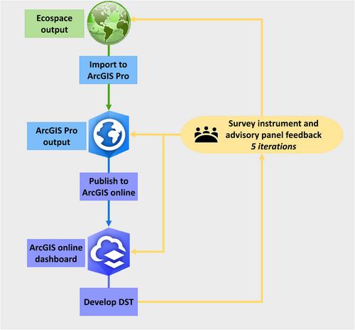
Two decisions were made prior to the ecosystem model development to facilitate the transfer of model output: (1) to engage and consult fisheries and restoration managers throughout ecosystem model development to ensure that the output would provide relevant information; and (2) to provide an accessible visualization tool for making ecosystem model output readily available to support the needs of decision makers.
Results from an advisory panel survey instrument and advisory panel meetings guided ecosystem model development and launched the development of a decision support tool. The iterative process of building a decision support tool incorporating feedback from survey instrument respondents resulted in an ESRI ArcGIS Dashboard that allows end-users to identify the effects of hypoxia and respondent-specified nutrient and hypoxia reduction goals on the biomass and distribution of fisheries species.
The intent is to aid managers who are actively working to address hypoxia in the Gulf of Mexico with easy-to-access information on the effects of planned actions and to encourage future modelers to apply action science principles to best address the needs of decision makers.


