Maulana Ibrahim Rau, Atriyon Julzarika, Natsuki Yoshikawa, Takanori Nagano, Masaomi Kimura, Budi Indra Setiawan, Lan Thanh Ha
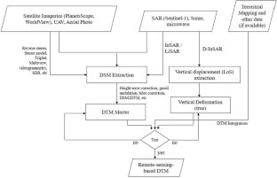
{"title":"Application of topographic elevation data generated by remote sensing approaches to flood inundation analysis model","authors":"Maulana Ibrahim Rau, Atriyon Julzarika, Natsuki Yoshikawa, Takanori Nagano, Masaomi Kimura, Budi Indra Setiawan, Lan Thanh Ha","doi":"10.1007/s10333-023-00967-1","DOIUrl":null,"url":null,"abstract":"<p>High-resolution topographic data are crucial for delta water management, such as hydrological modeling, inland flood routing, etc. Nevertheless, the availability of high-resolution topographic data is often lacking, particularly in low-lying regions in developing countries. This data scarcity poses a significant obstacle to inland flood modeling. However, collecting detailed topographic data is demanding, time-consuming, and costly, making remote sensing techniques a promising solution for developing flood inundation analysis models worldwide. This study presents a novel understanding for utilizing topographical elevations obtained using remote sensing techniques to create a flood inundation analysis model. In a study of three watersheds, Kameda, Niitsu, and Shirone (Japan), the assessment of digital terrain models (DTMs) showed that remote sensing-based DTMs (RS-DTMs) exhibited high reliability of coefficient of determination (<i>R</i><sup>2</sup>) and root-mean-square errors, compared with the airborne LiDAR-based topography from the Geospatial Information Authority of Japan. Comparing the flood modeling results from LiDAR data and RS-DTM, with Kameda and Niitsu performing favorable outcomes, Shirone exhibited less accurate results. We hypothesized that this was caused by the topographic distortions due to lack of evenly distributed reference points. Hence, we revised the topography by adjusting both the slope and intercept from the regression equation. This verification successfully showed that the flood inundation volume correlation improved, achieving <i>R</i><sup>2</sup> results for the three watersheds ranging from 0.975 to 0.997 and Nash–Sutcliffe Efficiencies ranging from 0.938 to 0.986 between the resulting flood models based on the LiDAR data and RS-DTM. Based on these findings, we recognized the significance of uniformly distributed geodetic height points. In areas lacking height references, high-precision survey instruments can be employed for achieving uniform distribution.</p>","PeriodicalId":56101,"journal":{"name":"Paddy and Water Environment","volume":"18 1","pages":""},"PeriodicalIF":2.1000,"publicationDate":"2024-02-08","publicationTypes":"Journal Article","fieldsOfStudy":null,"isOpenAccess":false,"openAccessPdf":"","citationCount":"0","resultStr":null,"platform":"Semanticscholar","paperid":null,"PeriodicalName":"Paddy and Water Environment","FirstCategoryId":"97","ListUrlMain":"https://doi.org/10.1007/s10333-023-00967-1","RegionNum":4,"RegionCategory":"农林科学","ArticlePicture":[],"TitleCN":null,"AbstractTextCN":null,"PMCID":null,"EPubDate":"","PubModel":"","JCR":"Q2","JCRName":"AGRICULTURAL ENGINEERING","Score":null,"Total":0}
引用次数: 0
Abstract
High-resolution topographic data are crucial for delta water management, such as hydrological modeling, inland flood routing, etc. Nevertheless, the availability of high-resolution topographic data is often lacking, particularly in low-lying regions in developing countries. This data scarcity poses a significant obstacle to inland flood modeling. However, collecting detailed topographic data is demanding, time-consuming, and costly, making remote sensing techniques a promising solution for developing flood inundation analysis models worldwide. This study presents a novel understanding for utilizing topographical elevations obtained using remote sensing techniques to create a flood inundation analysis model. In a study of three watersheds, Kameda, Niitsu, and Shirone (Japan), the assessment of digital terrain models (DTMs) showed that remote sensing-based DTMs (RS-DTMs) exhibited high reliability of coefficient of determination (R2) and root-mean-square errors, compared with the airborne LiDAR-based topography from the Geospatial Information Authority of Japan. Comparing the flood modeling results from LiDAR data and RS-DTM, with Kameda and Niitsu performing favorable outcomes, Shirone exhibited less accurate results. We hypothesized that this was caused by the topographic distortions due to lack of evenly distributed reference points. Hence, we revised the topography by adjusting both the slope and intercept from the regression equation. This verification successfully showed that the flood inundation volume correlation improved, achieving R2 results for the three watersheds ranging from 0.975 to 0.997 and Nash–Sutcliffe Efficiencies ranging from 0.938 to 0.986 between the resulting flood models based on the LiDAR data and RS-DTM. Based on these findings, we recognized the significance of uniformly distributed geodetic height points. In areas lacking height references, high-precision survey instruments can be employed for achieving uniform distribution.
期刊介绍:
The aim of Paddy and Water Environment is to advance the science and technology of water and environment related disciplines in paddy-farming. The scope includes the paddy-farming related scientific and technological aspects in agricultural engineering such as irrigation and drainage, soil and water conservation, land and water resources management, irrigation facilities and disaster management, paddy multi-functionality, agricultural policy, regional planning, bioenvironmental systems, and ecological conservation and restoration in paddy farming regions.


 分享
分享
 求助内容:
求助内容: 应助结果提醒方式:
 扫码关注我们
