{"title":"German and European Ground Motion Service: a Comparison","authors":"Markus Even, Malte Westerhaus, Hansjörg Kutterer","doi":"10.1007/s41064-024-00273-3","DOIUrl":null,"url":null,"abstract":"<p>Since the end of 2022, two ground motion services that cover the complete area of Germany are available as web services: the German Ground Motion Service (<i>Bodenbewegungsdienst Deutschland</i>, BBD) provided by the Federal Institute for Geosciences and Natural Resources (BGR), and the first release of the European Ground Motion Service (EGMS) as part of the Copernicus Land Monitoring Service. Both services are based on InSAR displacement estimations generated from Sentinel‑1 data. It would seem relevant to compare the products of the two services against one another, assess the data coverage they provide, and investigate how well they perform compared to other geodetic techniques. For a study commissioned by the surveying authority of the state of Baden-Württemberg (<i>Landesamt für Geoinformation und Landentwicklung Baden-Württemberg</i>, LGL), BBD and EGMS data from different locations in Baden-Württemberg, Saarland, and North Rhine-Westphalia (NRW) were investigated and validated against levelling and GNSS data. We found that both services provide good data quality. BBD shows slightly better calibration precision than EGMS. The coverage provided by EGMS is better than that of BBD on motorways, federal roads, and train tracks of the <i>Deutsche Bahn</i>. As an example, where both services have difficulties in determining the correct displacements, as they cannot be described well by the displacement models used for processing, we present the test case of the cavern field at Epe (NRW). Finally, we discuss the implications of our findings for the use of the products of BBD and EGMS for monitoring tasks.</p>","PeriodicalId":56035,"journal":{"name":"PFG-Journal of Photogrammetry Remote Sensing and Geoinformation Science","volume":"21 1","pages":""},"PeriodicalIF":3.3000,"publicationDate":"2024-02-27","publicationTypes":"Journal Article","fieldsOfStudy":null,"isOpenAccess":false,"openAccessPdf":"","citationCount":"0","resultStr":null,"platform":"Semanticscholar","paperid":null,"PeriodicalName":"PFG-Journal of Photogrammetry Remote Sensing and Geoinformation Science","FirstCategoryId":"89","ListUrlMain":"https://doi.org/10.1007/s41064-024-00273-3","RegionNum":4,"RegionCategory":"地球科学","ArticlePicture":[],"TitleCN":null,"AbstractTextCN":null,"PMCID":null,"EPubDate":"","PubModel":"","JCR":"Q3","JCRName":"IMAGING SCIENCE & PHOTOGRAPHIC TECHNOLOGY","Score":null,"Total":0}
引用次数: 0
Abstract
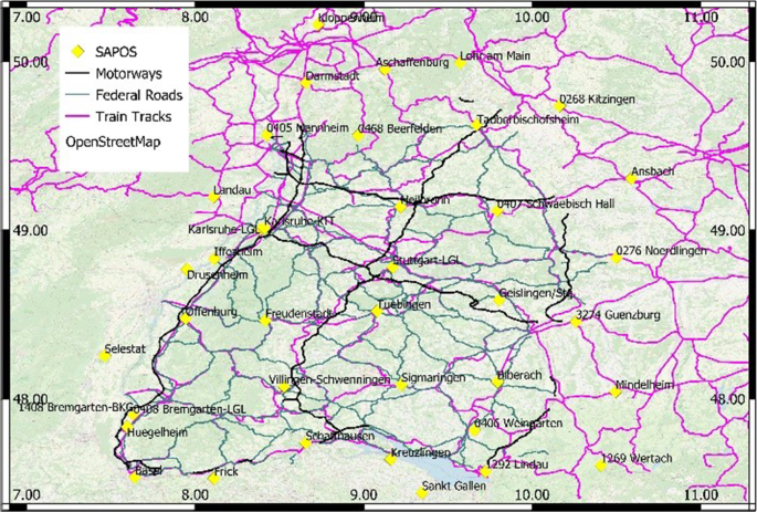
Since the end of 2022, two ground motion services that cover the complete area of Germany are available as web services: the German Ground Motion Service (Bodenbewegungsdienst Deutschland, BBD) provided by the Federal Institute for Geosciences and Natural Resources (BGR), and the first release of the European Ground Motion Service (EGMS) as part of the Copernicus Land Monitoring Service. Both services are based on InSAR displacement estimations generated from Sentinel‑1 data. It would seem relevant to compare the products of the two services against one another, assess the data coverage they provide, and investigate how well they perform compared to other geodetic techniques. For a study commissioned by the surveying authority of the state of Baden-Württemberg (Landesamt für Geoinformation und Landentwicklung Baden-Württemberg, LGL), BBD and EGMS data from different locations in Baden-Württemberg, Saarland, and North Rhine-Westphalia (NRW) were investigated and validated against levelling and GNSS data. We found that both services provide good data quality. BBD shows slightly better calibration precision than EGMS. The coverage provided by EGMS is better than that of BBD on motorways, federal roads, and train tracks of the Deutsche Bahn. As an example, where both services have difficulties in determining the correct displacements, as they cannot be described well by the displacement models used for processing, we present the test case of the cavern field at Epe (NRW). Finally, we discuss the implications of our findings for the use of the products of BBD and EGMS for monitoring tasks.
期刊介绍:
PFG is an international scholarly journal covering the progress and application of photogrammetric methods, remote sensing technology and the interconnected field of geoinformation science. It places special editorial emphasis on the communication of new methodologies in data acquisition and new approaches to optimized processing and interpretation of all types of data which were acquired by photogrammetric methods, remote sensing, image processing and the computer-aided interpretation of such data in general. The journal hence addresses both researchers and students of these disciplines at academic institutions and universities as well as the downstream users in both the private sector and public administration.
Founded in 1926 under the former name Bildmessung und Luftbildwesen, PFG is worldwide the oldest journal on photogrammetry. It is the official journal of the German Society for Photogrammetry, Remote Sensing and Geoinformation (DGPF).


 分享
分享
 求助内容:
求助内容: 应助结果提醒方式:
 扫码关注我们
