Tingjun Lei, Timothy Sellers, Chaomin Luo, Lei Cao, Zhuming Bi
{"title":"Digital twin-based multi-objective autonomous vehicle navigation approach as applied in infrastructure construction","authors":"Tingjun Lei, Timothy Sellers, Chaomin Luo, Lei Cao, Zhuming Bi","doi":"10.1049/csy2.12110","DOIUrl":null,"url":null,"abstract":"<p>The widespread adoption of autonomous vehicles has generated considerable interest in their autonomous operation, with path planning emerging as a critical aspect. However, existing road infrastructure confronts challenges due to prolonged use and insufficient maintenance. Previous research on autonomous vehicle navigation has focused on determining the trajectory with the shortest distance, while neglecting road construction information, leading to potential time and energy inefficiencies in real-world scenarios involving infrastructure development. To address this issue, a digital twin-embedded multi-objective autonomous vehicle navigation is proposed under the condition of infrastructure construction. The authors propose an image processing algorithm that leverages captured images of the road construction environment to enable road extraction and modelling of the autonomous vehicle workspace. Additionally, a wavelet neural network is developed to predict real-time traffic flow, considering its inherent characteristics. Moreover, a multi-objective brainstorm optimisation (BSO)-based method for path planning is introduced, which optimises total time-cost and energy consumption objective functions. To ensure optimal trajectory planning during infrastructure construction, the algorithm incorporates a real-time updated digital twin throughout autonomous vehicle operations. The effectiveness and robustness of the proposed model are validated through simulation and comparative studies conducted in diverse scenarios involving road construction. The results highlight the improved performance and reliability of the autonomous vehicle system when equipped with the authors’ approach, demonstrating its potential for enhancing efficiency and minimising disruptions caused by road infrastructure development.</p>","PeriodicalId":34110,"journal":{"name":"IET Cybersystems and Robotics","volume":"6 2","pages":""},"PeriodicalIF":1.2000,"publicationDate":"2024-03-20","publicationTypes":"Journal Article","fieldsOfStudy":null,"isOpenAccess":false,"openAccessPdf":"https://onlinelibrary.wiley.com/doi/epdf/10.1049/csy2.12110","citationCount":"0","resultStr":null,"platform":"Semanticscholar","paperid":null,"PeriodicalName":"IET Cybersystems and Robotics","FirstCategoryId":"1085","ListUrlMain":"https://ietresearch.onlinelibrary.wiley.com/doi/10.1049/csy2.12110","RegionNum":0,"RegionCategory":null,"ArticlePicture":[],"TitleCN":null,"AbstractTextCN":null,"PMCID":null,"EPubDate":"","PubModel":"","JCR":"Q3","JCRName":"AUTOMATION & CONTROL SYSTEMS","Score":null,"Total":0}
引用次数: 0
Abstract
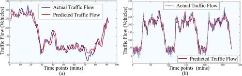
The widespread adoption of autonomous vehicles has generated considerable interest in their autonomous operation, with path planning emerging as a critical aspect. However, existing road infrastructure confronts challenges due to prolonged use and insufficient maintenance. Previous research on autonomous vehicle navigation has focused on determining the trajectory with the shortest distance, while neglecting road construction information, leading to potential time and energy inefficiencies in real-world scenarios involving infrastructure development. To address this issue, a digital twin-embedded multi-objective autonomous vehicle navigation is proposed under the condition of infrastructure construction. The authors propose an image processing algorithm that leverages captured images of the road construction environment to enable road extraction and modelling of the autonomous vehicle workspace. Additionally, a wavelet neural network is developed to predict real-time traffic flow, considering its inherent characteristics. Moreover, a multi-objective brainstorm optimisation (BSO)-based method for path planning is introduced, which optimises total time-cost and energy consumption objective functions. To ensure optimal trajectory planning during infrastructure construction, the algorithm incorporates a real-time updated digital twin throughout autonomous vehicle operations. The effectiveness and robustness of the proposed model are validated through simulation and comparative studies conducted in diverse scenarios involving road construction. The results highlight the improved performance and reliability of the autonomous vehicle system when equipped with the authors’ approach, demonstrating its potential for enhancing efficiency and minimising disruptions caused by road infrastructure development.


 分享
分享
 求助内容:
求助内容: 应助结果提醒方式:
 扫码关注我们
