A. P. Zhidkin, D. I. Rukhovich, K. A. Maltsev, P. V. Koroleva
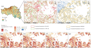
{"title":"Variation of Soil Erosion Estimates Based on Different Maps of Cropland in Belgorod Oblast, Russia","authors":"A. P. Zhidkin, D. I. Rukhovich, K. A. Maltsev, P. V. Koroleva","doi":"10.1134/s1064229323603293","DOIUrl":null,"url":null,"abstract":"<h3 data-test=\"abstract-sub-heading\">\n<b>Abstract</b>\n</h3><p>Current medium- and small-scale estimates of soil erosion in Russia are very few. At the same time, a favorable situation has now developed for assessing the rates and volumes of soil erosion losses. Erosion models adapted to available digital elevation models, various farmland maps, and climate databases are now available to researchers. We have estimated the rates and volumes of soil erosion with the use of different maps of cropland: world cover from the European Space Agency (ESA WC), global land cover and land use from the University of Maryland (GLCLU), the official unified federal information system of agricultural land (UFIS AL) from the Ministry of Agriculture of the Russian Federation, and the original conventionally reference land cover map of Alekseevskii district of Belgorod oblast. It has been found that the UFIS AL map gives cropland areas close to the average from first three maps. Public access maps (ESA WC and GLCLU) give maximum and minimum estimates of cropland, respectively. A comparison with the conventionally reference large-scale map shows that the accuracy of the UFIS AL does not exceed 90%; the accuracy of ESA WC and GLCLU maps is 84 and 83%, respectively. The total area of cropland in Belgorod oblast varies slightly (from 1445 to 1586 thousand hectares), which is favorable for erosion modeling. Deviations from the average rates of soil erosion calculated using different maps of cropland in the region as a whole are up to 7%; for some districts, they reach 27%. Thus, current estimates of soil erosion at the regional level can be carried out with an error of at least 10–15% only as a result of the uncertainty in mapping the boundaries of cropland. For Russia as a whole, data on the area of cropland vary significantly: from 80 to 132 million hectares. Consequently, the use of existing maps of cropland can lead to significant uncertainties in soil erosion estimates averaged at the level of the subjects of the Russian Federation and large regions.</p>","PeriodicalId":11892,"journal":{"name":"Eurasian Soil Science","volume":"126 1","pages":""},"PeriodicalIF":1.6000,"publicationDate":"2024-04-16","publicationTypes":"Journal Article","fieldsOfStudy":null,"isOpenAccess":false,"openAccessPdf":"","citationCount":"0","resultStr":null,"platform":"Semanticscholar","paperid":null,"PeriodicalName":"Eurasian Soil Science","FirstCategoryId":"97","ListUrlMain":"https://doi.org/10.1134/s1064229323603293","RegionNum":4,"RegionCategory":"农林科学","ArticlePicture":[],"TitleCN":null,"AbstractTextCN":null,"PMCID":null,"EPubDate":"","PubModel":"","JCR":"Q4","JCRName":"SOIL SCIENCE","Score":null,"Total":0}
引用次数: 0
Abstract
Current medium- and small-scale estimates of soil erosion in Russia are very few. At the same time, a favorable situation has now developed for assessing the rates and volumes of soil erosion losses. Erosion models adapted to available digital elevation models, various farmland maps, and climate databases are now available to researchers. We have estimated the rates and volumes of soil erosion with the use of different maps of cropland: world cover from the European Space Agency (ESA WC), global land cover and land use from the University of Maryland (GLCLU), the official unified federal information system of agricultural land (UFIS AL) from the Ministry of Agriculture of the Russian Federation, and the original conventionally reference land cover map of Alekseevskii district of Belgorod oblast. It has been found that the UFIS AL map gives cropland areas close to the average from first three maps. Public access maps (ESA WC and GLCLU) give maximum and minimum estimates of cropland, respectively. A comparison with the conventionally reference large-scale map shows that the accuracy of the UFIS AL does not exceed 90%; the accuracy of ESA WC and GLCLU maps is 84 and 83%, respectively. The total area of cropland in Belgorod oblast varies slightly (from 1445 to 1586 thousand hectares), which is favorable for erosion modeling. Deviations from the average rates of soil erosion calculated using different maps of cropland in the region as a whole are up to 7%; for some districts, they reach 27%. Thus, current estimates of soil erosion at the regional level can be carried out with an error of at least 10–15% only as a result of the uncertainty in mapping the boundaries of cropland. For Russia as a whole, data on the area of cropland vary significantly: from 80 to 132 million hectares. Consequently, the use of existing maps of cropland can lead to significant uncertainties in soil erosion estimates averaged at the level of the subjects of the Russian Federation and large regions.
期刊介绍:
Eurasian Soil Science publishes original research papers on global and regional studies discussing both theoretical and experimental problems of genesis, geography, physics, chemistry, biology, fertility, management, conservation, and remediation of soils. Special sections are devoted to current news in the life of the International and Russian soil science societies and to the history of soil sciences.
Since 2000, the journal Agricultural Chemistry, the English version of the journal of the Russian Academy of Sciences Agrokhimiya, has been merged into the journal Eurasian Soil Science and is no longer published as a separate title.


 分享
分享
 求助内容:
求助内容: 应助结果提醒方式:
 扫码关注我们
