Feleke K. Sishu , Seifu A. Tilahun , Petra Schmitter , Tammo S. Steenhuis
{"title":"Revisiting the Thornthwaite Mather procedure for baseflow and groundwater storage predictions in sloping and mountainous regions","authors":"Feleke K. Sishu , Seifu A. Tilahun , Petra Schmitter , Tammo S. Steenhuis","doi":"10.1016/j.hydroa.2024.100179","DOIUrl":null,"url":null,"abstract":"<div><p>Hillslope aquifers regulate streamflow and are a critical potable and irrigation water source, especially in developing countries. Knowing recharge and baseflow is essential for managing these aquifers. Methods using available data to calculate recharge and baseflow from aquifers are not valid for uplands. This paper adapts the Thornthwaite and Mather (T-M) procedure from plains to sloping and mountainous regions by replacing the linear reservoir with a zero-order aquifer. The revised T-M procedure was tested over four years in two contrasting watersheds in the humid Ethiopian highlands: the 57 km<sup>2</sup> Dangishta with a perennial stream and the nine km<sup>2</sup> Robit Bata, where the flow ceased four months after the end of the rain phase. The monthly average groundwater tables were predicted with an accuracy ranging from satisfactory to good for both watersheds. Baseflow predictions were “very good” after considering the evaporation from shallow groundwater in the valley bottom during the dry phase in Dangishta. We conclude that the T-M procedure is ideally suited for calculating recharge, baseflow and groundwater storage in upland regions with sparse hydrological data since the procedure uses as input only rainfall and potential evaporation data that are readily available together with an estimate of the aquifer travel time.</p></div>","PeriodicalId":36948,"journal":{"name":"Journal of Hydrology X","volume":"24 ","pages":"Article 100179"},"PeriodicalIF":3.1000,"publicationDate":"2024-08-01","publicationTypes":"Journal Article","fieldsOfStudy":null,"isOpenAccess":false,"openAccessPdf":"https://www.sciencedirect.com/science/article/pii/S2589915524000099/pdfft?md5=fcd021fe86a9e1229d0a54c3a5071e78&pid=1-s2.0-S2589915524000099-main.pdf","citationCount":"0","resultStr":null,"platform":"Semanticscholar","paperid":null,"PeriodicalName":"Journal of Hydrology X","FirstCategoryId":"1085","ListUrlMain":"https://www.sciencedirect.com/science/article/pii/S2589915524000099","RegionNum":0,"RegionCategory":null,"ArticlePicture":[],"TitleCN":null,"AbstractTextCN":null,"PMCID":null,"EPubDate":"2024/4/26 0:00:00","PubModel":"Epub","JCR":"Q2","JCRName":"GEOSCIENCES, MULTIDISCIPLINARY","Score":null,"Total":0}
引用次数: 0
Abstract
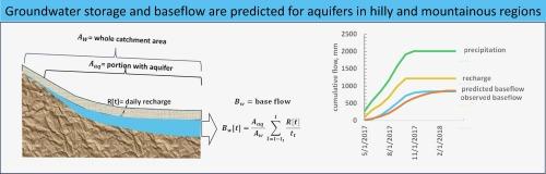
Hillslope aquifers regulate streamflow and are a critical potable and irrigation water source, especially in developing countries. Knowing recharge and baseflow is essential for managing these aquifers. Methods using available data to calculate recharge and baseflow from aquifers are not valid for uplands. This paper adapts the Thornthwaite and Mather (T-M) procedure from plains to sloping and mountainous regions by replacing the linear reservoir with a zero-order aquifer. The revised T-M procedure was tested over four years in two contrasting watersheds in the humid Ethiopian highlands: the 57 km2 Dangishta with a perennial stream and the nine km2 Robit Bata, where the flow ceased four months after the end of the rain phase. The monthly average groundwater tables were predicted with an accuracy ranging from satisfactory to good for both watersheds. Baseflow predictions were “very good” after considering the evaporation from shallow groundwater in the valley bottom during the dry phase in Dangishta. We conclude that the T-M procedure is ideally suited for calculating recharge, baseflow and groundwater storage in upland regions with sparse hydrological data since the procedure uses as input only rainfall and potential evaporation data that are readily available together with an estimate of the aquifer travel time.


 分享
分享
 求助内容:
求助内容: 应助结果提醒方式:
 扫码关注我们
