{"title":"Using geomorphologic indicators in preparation for flood zoning and flood risk maps in the Kashafroud basin, Iran","authors":"Ghasem Panahi, Saeed Reza Khodashenas, Alireza Faridhosseini","doi":"10.1111/jfr3.12981","DOIUrl":null,"url":null,"abstract":"<p>The risk of flooding has become more significant in many parts of the world due to climate change and increased urbanization. Flood has devastating effects on infrastructure, and communities, causing damage to property and loss of life. Simulation of flood extent in a particular area is done by using various mathematical models, hydrologic-hydraulic models, and datasets. Flood modeling using hydraulic-hydrological models has many errors due to the lack of hydraulic-hydrologic data and insufficient statistical period length. This study demonstrates the fact that the geomorphological index (GI) method, which is based on the digital elevation model and requires little hydraulic-hydrologic data, is an effective method for flood modeling. Flood zoning based on GI was performed within the Kashafroud basin with 25, 100, and 200-year return periods by using geomorphic flood area (GFA) plugin in QGIS software. The true positive rates were 0.985, 0.989, and 0.992, respectively, which showed the high accuracy of flood zoning based on the GI method. Here proposed method showed that using the GFA plugin offers a good way for the flood risk assessment in a basin with the lack of measured data as an alternative to the hydraulic-hydrological methods.</p>","PeriodicalId":49294,"journal":{"name":"Journal of Flood Risk Management","volume":"17 2","pages":""},"PeriodicalIF":3.0000,"publicationDate":"2024-03-07","publicationTypes":"Journal Article","fieldsOfStudy":null,"isOpenAccess":false,"openAccessPdf":"https://onlinelibrary.wiley.com/doi/epdf/10.1111/jfr3.12981","citationCount":"0","resultStr":null,"platform":"Semanticscholar","paperid":null,"PeriodicalName":"Journal of Flood Risk Management","FirstCategoryId":"93","ListUrlMain":"https://onlinelibrary.wiley.com/doi/10.1111/jfr3.12981","RegionNum":3,"RegionCategory":"环境科学与生态学","ArticlePicture":[],"TitleCN":null,"AbstractTextCN":null,"PMCID":null,"EPubDate":"","PubModel":"","JCR":"Q2","JCRName":"ENVIRONMENTAL SCIENCES","Score":null,"Total":0}
引用次数: 0
Abstract
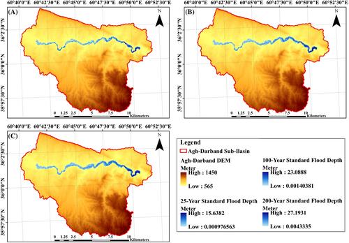
The risk of flooding has become more significant in many parts of the world due to climate change and increased urbanization. Flood has devastating effects on infrastructure, and communities, causing damage to property and loss of life. Simulation of flood extent in a particular area is done by using various mathematical models, hydrologic-hydraulic models, and datasets. Flood modeling using hydraulic-hydrological models has many errors due to the lack of hydraulic-hydrologic data and insufficient statistical period length. This study demonstrates the fact that the geomorphological index (GI) method, which is based on the digital elevation model and requires little hydraulic-hydrologic data, is an effective method for flood modeling. Flood zoning based on GI was performed within the Kashafroud basin with 25, 100, and 200-year return periods by using geomorphic flood area (GFA) plugin in QGIS software. The true positive rates were 0.985, 0.989, and 0.992, respectively, which showed the high accuracy of flood zoning based on the GI method. Here proposed method showed that using the GFA plugin offers a good way for the flood risk assessment in a basin with the lack of measured data as an alternative to the hydraulic-hydrological methods.
期刊介绍:
Journal of Flood Risk Management provides an international platform for knowledge sharing in all areas related to flood risk. Its explicit aim is to disseminate ideas across the range of disciplines where flood related research is carried out and it provides content ranging from leading edge academic papers to applied content with the practitioner in mind.
Readers and authors come from a wide background and include hydrologists, meteorologists, geographers, geomorphologists, conservationists, civil engineers, social scientists, policy makers, insurers and practitioners. They share an interest in managing the complex interactions between the many skills and disciplines that underpin the management of flood risk across the world.


 分享
分享
 求助内容:
求助内容: 应助结果提醒方式:
 扫码关注我们
