{"title":"Mapping the Potential for Erosion Gullies Using Frequency Ratio and Fuzzy Analytical Hierarchy Process: Case Study Medjerda Basin, Northeast Algeria","authors":"D. Mrad, S. Boukhari, S. Dairi, Y. Djebbar","doi":"10.1134/s1064229323603530","DOIUrl":null,"url":null,"abstract":"<h3 data-test=\"abstract-sub-heading\">Abstract</h3><p>Soil erosion poses a significant problem in the Mediterranean region, posing serious threats to the environment and natural resources. The objective of this study is to identify and evaluate the risks associated with gully erosion in the Medjerda watershed in the northeastern part of Algeria. To accomplish this goal, two models were utilized: the fuzzy analytic hierarchy process (F-AHP) and the frequency ratio (FR). Twelve factors that contribute to soil erosion were considered in the study: slope, elevation, distance to streams, land use and land cover, drainage density (DD), topographic wetness index (TWI), rainfall, soil groups, lineament density, soil power index (SPI), sediment transport index (STI), and plan curvature. The results indicate that sediment transport index (STI), rainfall, and slope are the most influential factors in predicting erosion in the Medjerda Basin. To validate the models used, the area under the receiver operating characteristics curve (AUC) was employed. The AUC values obtained for the FR and F-AHP models were 75.5 and 73.7%, respectively, indicating their excellent accuracy in identifying the erosion susceptibility area. The accuracy ratings of both models demonstrate their outstanding predictive capabilities. Thus, the results of soil erosion susceptibility maps with a better success rate and forecast could be beneficial and effective for implementing various policy measures to safeguard soil. They could be useful for managing gully erosion risks in different parts of the river basin.</p>","PeriodicalId":11892,"journal":{"name":"Eurasian Soil Science","volume":"6 1","pages":""},"PeriodicalIF":1.6000,"publicationDate":"2024-05-29","publicationTypes":"Journal Article","fieldsOfStudy":null,"isOpenAccess":false,"openAccessPdf":"","citationCount":"0","resultStr":null,"platform":"Semanticscholar","paperid":null,"PeriodicalName":"Eurasian Soil Science","FirstCategoryId":"97","ListUrlMain":"https://doi.org/10.1134/s1064229323603530","RegionNum":4,"RegionCategory":"农林科学","ArticlePicture":[],"TitleCN":null,"AbstractTextCN":null,"PMCID":null,"EPubDate":"","PubModel":"","JCR":"Q4","JCRName":"SOIL SCIENCE","Score":null,"Total":0}
引用次数: 0
Abstract
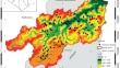
Soil erosion poses a significant problem in the Mediterranean region, posing serious threats to the environment and natural resources. The objective of this study is to identify and evaluate the risks associated with gully erosion in the Medjerda watershed in the northeastern part of Algeria. To accomplish this goal, two models were utilized: the fuzzy analytic hierarchy process (F-AHP) and the frequency ratio (FR). Twelve factors that contribute to soil erosion were considered in the study: slope, elevation, distance to streams, land use and land cover, drainage density (DD), topographic wetness index (TWI), rainfall, soil groups, lineament density, soil power index (SPI), sediment transport index (STI), and plan curvature. The results indicate that sediment transport index (STI), rainfall, and slope are the most influential factors in predicting erosion in the Medjerda Basin. To validate the models used, the area under the receiver operating characteristics curve (AUC) was employed. The AUC values obtained for the FR and F-AHP models were 75.5 and 73.7%, respectively, indicating their excellent accuracy in identifying the erosion susceptibility area. The accuracy ratings of both models demonstrate their outstanding predictive capabilities. Thus, the results of soil erosion susceptibility maps with a better success rate and forecast could be beneficial and effective for implementing various policy measures to safeguard soil. They could be useful for managing gully erosion risks in different parts of the river basin.
期刊介绍:
Eurasian Soil Science publishes original research papers on global and regional studies discussing both theoretical and experimental problems of genesis, geography, physics, chemistry, biology, fertility, management, conservation, and remediation of soils. Special sections are devoted to current news in the life of the International and Russian soil science societies and to the history of soil sciences.
Since 2000, the journal Agricultural Chemistry, the English version of the journal of the Russian Academy of Sciences Agrokhimiya, has been merged into the journal Eurasian Soil Science and is no longer published as a separate title.


 分享
分享
 求助内容:
求助内容: 应助结果提醒方式:
 扫码关注我们
