{"title":"Designing a rain gauge network: utilizing satellite-derived precipitation data with geostatistical multivariate techniques","authors":"Mahmood Reza Shaghaghian, Zahra Ghadampour","doi":"10.1007/s10333-024-00977-7","DOIUrl":null,"url":null,"abstract":"<p>Although numerous studies have investigated the validity of satellite-derived precipitation datasets, there has been a lack of emphasis on their practical applications. This study aims to explore the implications of such datasets in designing rain gauge networks, which are essential for acquiring reliable precipitation data. Initially, four satellite-derived precipitation datasets (PERSIANN, PERSIANN-CDR, PERSIANN-CCS, and TRMM 3B43 V.7) were statistically compared to ground-based observations from 23 synoptic stations within the Fars province in southwestern Iran, the designated study area, to assess their validity. Furthermore, to provide a technical comparison, the degree of spatial independence (variogram) derived from these datasets was compared to that obtained from ground-based observations. To meet the study's objectives, a detrending process was implemented to render the datasets isotropic and bounded. Among the aforementioned satellite-derived datasets, PERSIANN-CCS and TRMM 3B43 V.7 demonstrated promise for enhancement to be utilized in rain gauge network design through a hybrid method combining multivariate analysis incorporating factor analysis and a geostatistical approach incorporating ordinary (point and block) kriging. Based on the PERSIANN-CCS and TRMM 3B43 V.7 satellite-derived datasets, rain gauge grids containing 70 and 56 rain gauges were initially proposed using a scree diagram. However, after considering a predetermined level of accuracy (block variance of residuals set to 10 <span>\\({mm}^{2}\\)</span>), the numbers were subsequently reduced to 56 and 28 rain gauges, respectively. Consequently, this research sheds light on the practical utility of satellite-based precipitation datasets in the development of rain gauge networks in regions with insufficient data coverage or for evaluating existing networks.</p>","PeriodicalId":56101,"journal":{"name":"Paddy and Water Environment","volume":"8 1","pages":""},"PeriodicalIF":2.1000,"publicationDate":"2024-06-04","publicationTypes":"Journal Article","fieldsOfStudy":null,"isOpenAccess":false,"openAccessPdf":"","citationCount":"0","resultStr":null,"platform":"Semanticscholar","paperid":null,"PeriodicalName":"Paddy and Water Environment","FirstCategoryId":"97","ListUrlMain":"https://doi.org/10.1007/s10333-024-00977-7","RegionNum":4,"RegionCategory":"农林科学","ArticlePicture":[],"TitleCN":null,"AbstractTextCN":null,"PMCID":null,"EPubDate":"","PubModel":"","JCR":"Q2","JCRName":"AGRICULTURAL ENGINEERING","Score":null,"Total":0}
引用次数: 0
Abstract
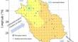
Although numerous studies have investigated the validity of satellite-derived precipitation datasets, there has been a lack of emphasis on their practical applications. This study aims to explore the implications of such datasets in designing rain gauge networks, which are essential for acquiring reliable precipitation data. Initially, four satellite-derived precipitation datasets (PERSIANN, PERSIANN-CDR, PERSIANN-CCS, and TRMM 3B43 V.7) were statistically compared to ground-based observations from 23 synoptic stations within the Fars province in southwestern Iran, the designated study area, to assess their validity. Furthermore, to provide a technical comparison, the degree of spatial independence (variogram) derived from these datasets was compared to that obtained from ground-based observations. To meet the study's objectives, a detrending process was implemented to render the datasets isotropic and bounded. Among the aforementioned satellite-derived datasets, PERSIANN-CCS and TRMM 3B43 V.7 demonstrated promise for enhancement to be utilized in rain gauge network design through a hybrid method combining multivariate analysis incorporating factor analysis and a geostatistical approach incorporating ordinary (point and block) kriging. Based on the PERSIANN-CCS and TRMM 3B43 V.7 satellite-derived datasets, rain gauge grids containing 70 and 56 rain gauges were initially proposed using a scree diagram. However, after considering a predetermined level of accuracy (block variance of residuals set to 10 \({mm}^{2}\)), the numbers were subsequently reduced to 56 and 28 rain gauges, respectively. Consequently, this research sheds light on the practical utility of satellite-based precipitation datasets in the development of rain gauge networks in regions with insufficient data coverage or for evaluating existing networks.
期刊介绍:
The aim of Paddy and Water Environment is to advance the science and technology of water and environment related disciplines in paddy-farming. The scope includes the paddy-farming related scientific and technological aspects in agricultural engineering such as irrigation and drainage, soil and water conservation, land and water resources management, irrigation facilities and disaster management, paddy multi-functionality, agricultural policy, regional planning, bioenvironmental systems, and ecological conservation and restoration in paddy farming regions.


 分享
分享
 求助内容:
求助内容: 应助结果提醒方式:
 扫码关注我们
