Abdelfattah Aboulfaraj, Abdelhalim Tabit, Ahmed Algouti, Abdellah Algouti, Said Moujane, Abdelouahed Farah, Idir El Konty, Soukaina Baid
{"title":"Contribution of Remote Sensing and Structural Geology in the Mapping of Tectonic Fractures in the Zat Region (Western High Atlas, Morocco)","authors":"Abdelfattah Aboulfaraj, Abdelhalim Tabit, Ahmed Algouti, Abdellah Algouti, Said Moujane, Abdelouahed Farah, Idir El Konty, Soukaina Baid","doi":"10.1007/s12524-024-01891-5","DOIUrl":null,"url":null,"abstract":"<p>The Zat region has a Precambrian basement that is partially covered by deformed Phanerozoic terrains. The last three orogeneses that Morocco experienced, from the Precambrian to the Quaternary, shaped this region. We used optical imagery from Landsat 8 OLI and ASTER DEM to map the tectonic fractures in this region. First, radiometric and geometric corrections were taken into account. Then, during the automatic extraction of lineaments, directional filters were used. Many approaches were used in the validation procedure, including the creation of false colour images, principal component analysis, and the removal of artificial lineaments by superimposing them on geological and topographic maps, Google Earth data, and field measurements. The listed lineaments have four major directional ranges: N–S, NW–SE, E–W, and NE–SW. The Hercynian and Alpine fractures are designated by the N–S and NE–SW directions, respectively. However, Precambrian filled fractures are distinguished by lineaments that fluctuate in the WNW–ESE direction. The geographical distribution of lineaments demonstrates the presence of two hard nuclei (Ourika gneissic massif and Afra ignimbritic massif) having controlled the region’s deformation. The region’s tectonic intensity decreases at the level of these nuclei and increases at the level of the surrounding terrains, which may include mineralising indices. This study highlights a region that is likely to be mined because of its geological and structural heritage.</p>","PeriodicalId":17510,"journal":{"name":"Journal of the Indian Society of Remote Sensing","volume":"89 1","pages":""},"PeriodicalIF":2.2000,"publicationDate":"2024-06-03","publicationTypes":"Journal Article","fieldsOfStudy":null,"isOpenAccess":false,"openAccessPdf":"","citationCount":"0","resultStr":null,"platform":"Semanticscholar","paperid":null,"PeriodicalName":"Journal of the Indian Society of Remote Sensing","FirstCategoryId":"5","ListUrlMain":"https://doi.org/10.1007/s12524-024-01891-5","RegionNum":4,"RegionCategory":"地球科学","ArticlePicture":[],"TitleCN":null,"AbstractTextCN":null,"PMCID":null,"EPubDate":"","PubModel":"","JCR":"Q3","JCRName":"ENVIRONMENTAL SCIENCES","Score":null,"Total":0}
引用次数: 0
Abstract
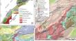
The Zat region has a Precambrian basement that is partially covered by deformed Phanerozoic terrains. The last three orogeneses that Morocco experienced, from the Precambrian to the Quaternary, shaped this region. We used optical imagery from Landsat 8 OLI and ASTER DEM to map the tectonic fractures in this region. First, radiometric and geometric corrections were taken into account. Then, during the automatic extraction of lineaments, directional filters were used. Many approaches were used in the validation procedure, including the creation of false colour images, principal component analysis, and the removal of artificial lineaments by superimposing them on geological and topographic maps, Google Earth data, and field measurements. The listed lineaments have four major directional ranges: N–S, NW–SE, E–W, and NE–SW. The Hercynian and Alpine fractures are designated by the N–S and NE–SW directions, respectively. However, Precambrian filled fractures are distinguished by lineaments that fluctuate in the WNW–ESE direction. The geographical distribution of lineaments demonstrates the presence of two hard nuclei (Ourika gneissic massif and Afra ignimbritic massif) having controlled the region’s deformation. The region’s tectonic intensity decreases at the level of these nuclei and increases at the level of the surrounding terrains, which may include mineralising indices. This study highlights a region that is likely to be mined because of its geological and structural heritage.
期刊介绍:
The aims and scope of the Journal of the Indian Society of Remote Sensing are to help towards advancement, dissemination and application of the knowledge of Remote Sensing technology, which is deemed to include photo interpretation, photogrammetry, aerial photography, image processing, and other related technologies in the field of survey, planning and management of natural resources and other areas of application where the technology is considered to be appropriate, to promote interaction among all persons, bodies, institutions (private and/or state-owned) and industries interested in achieving advancement, dissemination and application of the technology, to encourage and undertake research in remote sensing and related technologies and to undertake and execute all acts which shall promote all or any of the aims and objectives of the Indian Society of Remote Sensing.


 分享
分享
 求助内容:
求助内容: 应助结果提醒方式:
 扫码关注我们
