{"title":"Study on Tobacco Plant Cross-Level Recognition in Complex Habitats in Karst Mountainous Areas Based on the U-Net Model","authors":"Qianxia Li, Lihui Yan, Zhongfa Zhou, Denghong Huang, Dongna Xiao, Youyan Huang","doi":"10.1007/s12524-024-01932-z","DOIUrl":null,"url":null,"abstract":"<p>The extraction of crop information is one of the important research directions for precision agriculture remote sensing. Crop extraction is of great significance in crop refinement management, precision fertilization, growth monitoring and yield precision estimation. The karst mountainous areas in southern China are characterized by undulating terrain, broken cultivated land, scattered spatial distribution of tobacco planting plots, uneven growth of plants, and mixed planting of crops. As the flight height of UAVs increases, the area of tobacco planting plots decreases, and the texture features become increasingly blurred, which increases the difficulty of segmentation and affects the recognition accuracy. We conducted this study to explore whether the high-resolution sample datasets and the trained U-Net model are suitable for cross-level recognition. In this study, DJI Mavic 2 Pro was used to collect UAV RGB images with flight heights of 50 m, 60 m, 70 m and 90 m in complex habitats for extracting tobacco plants from the U-Net model. The results are as follows: (1) The precision of tobacco plant segmentation at different altitudes is 50 m > 60 m > 70 m > 90 m, and Kappa coefficient is 0.92, 0.89, 0.86 and 0.34; the pressure is 0.96, 0.94, 0.93 and 0.22; the recall is 0.91, 0.90, 0.86 and 0.24; and the IoU is 0.88, 0.85, 0.8 and 0.23, respectively; and the precision of complex background segmentation is: a small number of weeds > a large number of weeds, and the plot is flat > the plot is broken. (2) With increasing flight height, the precision of tobacco segmentation of the U-Net model gradually decreases. Compared with 50 m, the precision of the 60 m segmentation results is reduced by 0.03, 0.02, 0.01 and 0.03, and that of 70 m is reduced by 0.06, 0.03, 0.05 and 0.08. The precision of the 90 m segmentation results is reduced by 0.58, 0.74, 0.67 and 0.65. The flight heights of 50 m, 60 m and 70 m have good experimental results, but the precision of 90 m segmentation is poor. The precision is mainly affected by the two factors of floor height and light. This study verified the feasibility and reliability of the high-precision extraction of tobacco plants at different altitudes by U-Net in complex habitats and has a certain reference value for research on the methodology and technical system of the deep learning recognition of crops in complex habitats in karst mountains.</p>","PeriodicalId":17510,"journal":{"name":"Journal of the Indian Society of Remote Sensing","volume":"31 1","pages":""},"PeriodicalIF":2.2000,"publicationDate":"2024-07-03","publicationTypes":"Journal Article","fieldsOfStudy":null,"isOpenAccess":false,"openAccessPdf":"","citationCount":"0","resultStr":null,"platform":"Semanticscholar","paperid":null,"PeriodicalName":"Journal of the Indian Society of Remote Sensing","FirstCategoryId":"5","ListUrlMain":"https://doi.org/10.1007/s12524-024-01932-z","RegionNum":4,"RegionCategory":"地球科学","ArticlePicture":[],"TitleCN":null,"AbstractTextCN":null,"PMCID":null,"EPubDate":"","PubModel":"","JCR":"Q3","JCRName":"ENVIRONMENTAL SCIENCES","Score":null,"Total":0}
引用次数: 0
Abstract
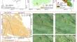
The extraction of crop information is one of the important research directions for precision agriculture remote sensing. Crop extraction is of great significance in crop refinement management, precision fertilization, growth monitoring and yield precision estimation. The karst mountainous areas in southern China are characterized by undulating terrain, broken cultivated land, scattered spatial distribution of tobacco planting plots, uneven growth of plants, and mixed planting of crops. As the flight height of UAVs increases, the area of tobacco planting plots decreases, and the texture features become increasingly blurred, which increases the difficulty of segmentation and affects the recognition accuracy. We conducted this study to explore whether the high-resolution sample datasets and the trained U-Net model are suitable for cross-level recognition. In this study, DJI Mavic 2 Pro was used to collect UAV RGB images with flight heights of 50 m, 60 m, 70 m and 90 m in complex habitats for extracting tobacco plants from the U-Net model. The results are as follows: (1) The precision of tobacco plant segmentation at different altitudes is 50 m > 60 m > 70 m > 90 m, and Kappa coefficient is 0.92, 0.89, 0.86 and 0.34; the pressure is 0.96, 0.94, 0.93 and 0.22; the recall is 0.91, 0.90, 0.86 and 0.24; and the IoU is 0.88, 0.85, 0.8 and 0.23, respectively; and the precision of complex background segmentation is: a small number of weeds > a large number of weeds, and the plot is flat > the plot is broken. (2) With increasing flight height, the precision of tobacco segmentation of the U-Net model gradually decreases. Compared with 50 m, the precision of the 60 m segmentation results is reduced by 0.03, 0.02, 0.01 and 0.03, and that of 70 m is reduced by 0.06, 0.03, 0.05 and 0.08. The precision of the 90 m segmentation results is reduced by 0.58, 0.74, 0.67 and 0.65. The flight heights of 50 m, 60 m and 70 m have good experimental results, but the precision of 90 m segmentation is poor. The precision is mainly affected by the two factors of floor height and light. This study verified the feasibility and reliability of the high-precision extraction of tobacco plants at different altitudes by U-Net in complex habitats and has a certain reference value for research on the methodology and technical system of the deep learning recognition of crops in complex habitats in karst mountains.
期刊介绍:
The aims and scope of the Journal of the Indian Society of Remote Sensing are to help towards advancement, dissemination and application of the knowledge of Remote Sensing technology, which is deemed to include photo interpretation, photogrammetry, aerial photography, image processing, and other related technologies in the field of survey, planning and management of natural resources and other areas of application where the technology is considered to be appropriate, to promote interaction among all persons, bodies, institutions (private and/or state-owned) and industries interested in achieving advancement, dissemination and application of the technology, to encourage and undertake research in remote sensing and related technologies and to undertake and execute all acts which shall promote all or any of the aims and objectives of the Indian Society of Remote Sensing.


 分享
分享
 求助内容:
求助内容: 应助结果提醒方式:
 扫码关注我们
