Sungchan Jeong , Youngryel Ryu , Pierre Gentine , Xu Lian , Jianing Fang , Xing Li , Benjamin Dechant , Juwon Kong , Wonseok Choi , Chongya Jiang , Trevor F. Keenan , Sandy P. Harrison , Iain Colin Prentice
{"title":"Persistent global greening over the last four decades using novel long-term vegetation index data with enhanced temporal consistency","authors":"Sungchan Jeong , Youngryel Ryu , Pierre Gentine , Xu Lian , Jianing Fang , Xing Li , Benjamin Dechant , Juwon Kong , Wonseok Choi , Chongya Jiang , Trevor F. Keenan , Sandy P. Harrison , Iain Colin Prentice","doi":"10.1016/j.rse.2024.114282","DOIUrl":null,"url":null,"abstract":"<div><p>Advanced Very High-Resolution Radiometer (AVHRR) satellite observations have provided the longest global daily records from 1980s, but the remaining temporal inconsistency in vegetation index datasets has hindered reliable assessment of vegetation greenness trends. To tackle this, we generated novel global long-term Normalized Difference Vegetation Index (NDVI) and Near-Infrared Reflectance of vegetation (NIRv) datasets derived from AVHRR and Moderate Resolution Imaging Spectroradiometer (MODIS). We addressed residual temporal inconsistency through three-step post processing including cross-sensor calibration among AVHRR sensors, orbital drifting correction for AVHRR sensors, and machine learning-based harmonization between AVHRR and MODIS. After applying each processing step, we confirmed the enhanced temporal consistency in terms of detrended anomaly, trend and interannual variability of NDVI and NIRv at calibration sites. Our refined NDVI and NIRv datasets showed a persistent global greening trend over the last four decades (NDVI: 0.0008 yr<sup>−1</sup>; NIRv: 0.0003 yr<sup>−1</sup>), contrasting with those without the three processing steps that showed rapid greening trends before 2000 (NDVI: 0.0017 yr<sup>−1</sup>; NIRv: 0.0008 yr<sup>−1</sup>) and weakened greening trends after 2000 (NDVI: 0.0004 yr<sup>−1</sup>; NIRv: 0.0001 yr<sup>−1</sup>). These findings highlight the importance of minimizing temporal inconsistency in long-term vegetation index datasets, which can support more reliable trend analysis in global vegetation response to climate changes.</p></div>","PeriodicalId":417,"journal":{"name":"Remote Sensing of Environment","volume":"311 ","pages":"Article 114282"},"PeriodicalIF":11.4000,"publicationDate":"2024-07-02","publicationTypes":"Journal Article","fieldsOfStudy":null,"isOpenAccess":false,"openAccessPdf":"","citationCount":"0","resultStr":null,"platform":"Semanticscholar","paperid":null,"PeriodicalName":"Remote Sensing of Environment","FirstCategoryId":"5","ListUrlMain":"https://www.sciencedirect.com/science/article/pii/S0034425724003006","RegionNum":1,"RegionCategory":"地球科学","ArticlePicture":[],"TitleCN":null,"AbstractTextCN":null,"PMCID":null,"EPubDate":"","PubModel":"","JCR":"Q1","JCRName":"ENVIRONMENTAL SCIENCES","Score":null,"Total":0}
引用次数: 0
Abstract
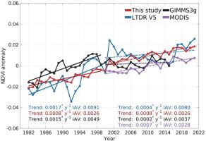
Advanced Very High-Resolution Radiometer (AVHRR) satellite observations have provided the longest global daily records from 1980s, but the remaining temporal inconsistency in vegetation index datasets has hindered reliable assessment of vegetation greenness trends. To tackle this, we generated novel global long-term Normalized Difference Vegetation Index (NDVI) and Near-Infrared Reflectance of vegetation (NIRv) datasets derived from AVHRR and Moderate Resolution Imaging Spectroradiometer (MODIS). We addressed residual temporal inconsistency through three-step post processing including cross-sensor calibration among AVHRR sensors, orbital drifting correction for AVHRR sensors, and machine learning-based harmonization between AVHRR and MODIS. After applying each processing step, we confirmed the enhanced temporal consistency in terms of detrended anomaly, trend and interannual variability of NDVI and NIRv at calibration sites. Our refined NDVI and NIRv datasets showed a persistent global greening trend over the last four decades (NDVI: 0.0008 yr−1; NIRv: 0.0003 yr−1), contrasting with those without the three processing steps that showed rapid greening trends before 2000 (NDVI: 0.0017 yr−1; NIRv: 0.0008 yr−1) and weakened greening trends after 2000 (NDVI: 0.0004 yr−1; NIRv: 0.0001 yr−1). These findings highlight the importance of minimizing temporal inconsistency in long-term vegetation index datasets, which can support more reliable trend analysis in global vegetation response to climate changes.
期刊介绍:
Remote Sensing of Environment (RSE) serves the Earth observation community by disseminating results on the theory, science, applications, and technology that contribute to advancing the field of remote sensing. With a thoroughly interdisciplinary approach, RSE encompasses terrestrial, oceanic, and atmospheric sensing.
The journal emphasizes biophysical and quantitative approaches to remote sensing at local to global scales, covering a diverse range of applications and techniques.
RSE serves as a vital platform for the exchange of knowledge and advancements in the dynamic field of remote sensing.


 分享
分享
 求助内容:
求助内容: 应助结果提醒方式:
 扫码关注我们
