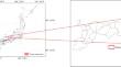
{"title":"Landscape metric sensitivity to grain size in rural Japan","authors":"Sadahisa Kato, Akari Motobe","doi":"10.1007/s11355-024-00611-y","DOIUrl":null,"url":null,"abstract":"<p>In this study, we investigated the sensitivity of landscape metrics to varying grain sizes in a rural, forested landscape in Japan, contributing to a broader understanding of landscape metric behavior across different scales. We analyzed six class-level and two landscape-level metrics on a land use map at grain sizes of 5, 10, 20, 30, 40, 50, 75, and 100 m. Our results indicate that the effect of increasing grain size on landscape metrics varies depending on the specific metric and land use type. Key metrics, such as the percentage of land use types in a landscape, and two landscape-level metrics showed minimal change across the range of grain sizes. Conversely, patch density and cohesion decreased, whereas Euclidean nearest neighbor distance increased. In addition, the patch area and radius of gyration showed variable responses across different land use types, influenced by their characteristic dimensions. This study highlights the limitations of using coarse-resolution data for detailed landscape analysis, as it may not fully capture landscape change or the relationship between landscape patterns and ecological processes. We propose an optimal grain size of 5–50 m for analyzing rural forested landscapes in Japan, which effectively captures fine-scale elements critical for biodiversity conservation. This range allows accurate comparisons between different regions and land use plans, especially in <i>satoyama</i> landscapes. This research highlights the importance of selecting appropriate grain size in landscape analysis and interpretation of landscape metrics as well as urges researchers and policymakers to ensure accurate ecological assessments and informed decision-making.</p>","PeriodicalId":49920,"journal":{"name":"Landscape and Ecological Engineering","volume":"25 1","pages":""},"PeriodicalIF":1.9000,"publicationDate":"2024-07-04","publicationTypes":"Journal Article","fieldsOfStudy":null,"isOpenAccess":false,"openAccessPdf":"","citationCount":"0","resultStr":null,"platform":"Semanticscholar","paperid":null,"PeriodicalName":"Landscape and Ecological Engineering","FirstCategoryId":"93","ListUrlMain":"https://doi.org/10.1007/s11355-024-00611-y","RegionNum":4,"RegionCategory":"环境科学与生态学","ArticlePicture":[],"TitleCN":null,"AbstractTextCN":null,"PMCID":null,"EPubDate":"","PubModel":"","JCR":"Q2","JCRName":"BIODIVERSITY CONSERVATION","Score":null,"Total":0}
引用次数: 0
Abstract
In this study, we investigated the sensitivity of landscape metrics to varying grain sizes in a rural, forested landscape in Japan, contributing to a broader understanding of landscape metric behavior across different scales. We analyzed six class-level and two landscape-level metrics on a land use map at grain sizes of 5, 10, 20, 30, 40, 50, 75, and 100 m. Our results indicate that the effect of increasing grain size on landscape metrics varies depending on the specific metric and land use type. Key metrics, such as the percentage of land use types in a landscape, and two landscape-level metrics showed minimal change across the range of grain sizes. Conversely, patch density and cohesion decreased, whereas Euclidean nearest neighbor distance increased. In addition, the patch area and radius of gyration showed variable responses across different land use types, influenced by their characteristic dimensions. This study highlights the limitations of using coarse-resolution data for detailed landscape analysis, as it may not fully capture landscape change or the relationship between landscape patterns and ecological processes. We propose an optimal grain size of 5–50 m for analyzing rural forested landscapes in Japan, which effectively captures fine-scale elements critical for biodiversity conservation. This range allows accurate comparisons between different regions and land use plans, especially in satoyama landscapes. This research highlights the importance of selecting appropriate grain size in landscape analysis and interpretation of landscape metrics as well as urges researchers and policymakers to ensure accurate ecological assessments and informed decision-making.
期刊介绍:
Landscape and Ecological Engineering is published by the International Consortium of Landscape and Ecological Engineering (ICLEE) in the interests of protecting and improving the environment in the face of biodiversity loss, desertification, global warming, and other environmental conditions.
The journal invites original papers, reports, reviews and technical notes on all aspects of conservation, restoration, and management of ecosystems. It is not limited to purely scientific approaches, but welcomes technological and design approaches that provide useful and practical solutions to today''s environmental problems. The journal''s coverage is relevant to universities and research institutes, while its emphasis on the practical application of research will be important to all decision makers dealing with landscape planning and management problems.


 分享
分享
 求助内容:
求助内容: 应助结果提醒方式:
 扫码关注我们
