Xingduo Ma , Yalin Li , Xiaodong Tan , Shuai Li , Jianbo Cheng , Zijian Li , Song Huang
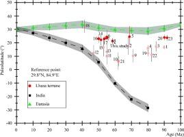
{"title":"A paleomagnetic study of the late paleocene sedimentary succession in the xigaze forearc basin, southern tibet, and its tectonic implications","authors":"Xingduo Ma , Yalin Li , Xiaodong Tan , Shuai Li , Jianbo Cheng , Zijian Li , Song Huang","doi":"10.1016/j.jseaes.2024.106277","DOIUrl":null,"url":null,"abstract":"<div><p>This study aims to constrain the paleolatitude of the southern margin of the Lhasa terrane during the late Paleocene and refine the constraints on intracontinental shortening within Asia resulting from the India–Asia collision. An integrated paleomagnetic and petrographic study was conducted on the upper Paleocene Jialazi Formation in the Xigaze forearc basin, southern Tibet. The limestone in the Jialazi Formation was demonstrated to reliably preserve primary remanence. Combined with previously published data, the tilt-corrected mean direction was Ds = 166.6° and Is = -38.2° with α<sub>95</sub> = 4.1 (n = 118), corresponding to a paleomagnetic pole at 75.3°N, 323.4°E, with an A<sub>95</sub> of 3.7°. Consequently, the paleolatitude of the Xigaze forearc basin from 56–59 Ma was estimated at ∼ 21.5°N for the reference point at 29.8°N, 84.9°E. Compared with data from the western Lhasa terrane, the Xigaze forearc basin and the Linzhou Basin, these findings suggest that the southern margin of the Lhasa terrane had an east–west orientation during the Late Cretaceous–early Eocene. A comparison with the apparent polar wander paths for Asia indicates that the intracontinental shortening between the Lhasa terrane and stable Asian interior has been 890 ± 470 km since the late Paleocene.</p></div>","PeriodicalId":50253,"journal":{"name":"Journal of Asian Earth Sciences","volume":"275 ","pages":"Article 106277"},"PeriodicalIF":2.4000,"publicationDate":"2024-08-08","publicationTypes":"Journal Article","fieldsOfStudy":null,"isOpenAccess":false,"openAccessPdf":"","citationCount":"0","resultStr":null,"platform":"Semanticscholar","paperid":null,"PeriodicalName":"Journal of Asian Earth Sciences","FirstCategoryId":"89","ListUrlMain":"https://www.sciencedirect.com/science/article/pii/S1367912024002724","RegionNum":3,"RegionCategory":"地球科学","ArticlePicture":[],"TitleCN":null,"AbstractTextCN":null,"PMCID":null,"EPubDate":"","PubModel":"","JCR":"Q2","JCRName":"GEOSCIENCES, MULTIDISCIPLINARY","Score":null,"Total":0}
引用次数: 0
Abstract
This study aims to constrain the paleolatitude of the southern margin of the Lhasa terrane during the late Paleocene and refine the constraints on intracontinental shortening within Asia resulting from the India–Asia collision. An integrated paleomagnetic and petrographic study was conducted on the upper Paleocene Jialazi Formation in the Xigaze forearc basin, southern Tibet. The limestone in the Jialazi Formation was demonstrated to reliably preserve primary remanence. Combined with previously published data, the tilt-corrected mean direction was Ds = 166.6° and Is = -38.2° with α95 = 4.1 (n = 118), corresponding to a paleomagnetic pole at 75.3°N, 323.4°E, with an A95 of 3.7°. Consequently, the paleolatitude of the Xigaze forearc basin from 56–59 Ma was estimated at ∼ 21.5°N for the reference point at 29.8°N, 84.9°E. Compared with data from the western Lhasa terrane, the Xigaze forearc basin and the Linzhou Basin, these findings suggest that the southern margin of the Lhasa terrane had an east–west orientation during the Late Cretaceous–early Eocene. A comparison with the apparent polar wander paths for Asia indicates that the intracontinental shortening between the Lhasa terrane and stable Asian interior has been 890 ± 470 km since the late Paleocene.
期刊介绍:
Journal of Asian Earth Sciences has an open access mirror journal Journal of Asian Earth Sciences: X, sharing the same aims and scope, editorial team, submission system and rigorous peer review.
The Journal of Asian Earth Sciences is an international interdisciplinary journal devoted to all aspects of research related to the solid Earth Sciences of Asia. The Journal publishes high quality, peer-reviewed scientific papers on the regional geology, tectonics, geochemistry and geophysics of Asia. It will be devoted primarily to research papers but short communications relating to new developments of broad interest, reviews and book reviews will also be included. Papers must have international appeal and should present work of more than local significance.
The scope includes deep processes of the Asian continent and its adjacent oceans; seismology and earthquakes; orogeny, magmatism, metamorphism and volcanism; growth, deformation and destruction of the Asian crust; crust-mantle interaction; evolution of life (early life, biostratigraphy, biogeography and mass-extinction); fluids, fluxes and reservoirs of mineral and energy resources; surface processes (weathering, erosion, transport and deposition of sediments) and resulting geomorphology; and the response of the Earth to global climate change as viewed within the Asian continent and surrounding oceans.


 分享
分享
 求助内容:
求助内容: 应助结果提醒方式:
 扫码关注我们
