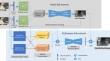
{"title":"EnhancedNet, an End-to-End Network for Dense Disparity Estimation and its Application to Aerial Images","authors":"Junhua Kang, Lin Chen, Christian Heipke","doi":"10.1007/s41064-024-00307-w","DOIUrl":null,"url":null,"abstract":"<p>Recent developments in deep learning technology have boosted the performance of dense stereo reconstruction. However, the state-of-the-art deep learning-based stereo matching methods are mainly trained using close-range synthetic images. Consequently, the application of these methods in aerial photogrammetry and remote sensing is currently far from straightforward. In this paper, we propose a new disparity estimation network for stereo matching and investigate its generalization abilities in regard to aerial images. First, we propose an end-to-end deep learning network for stereo matching, regularized by disparity gradients, which includes a residual cost volume and a reconstruction error volume in a refinement module, and multiple losses. In order to investigate the influence of the multiple losses, a comprehensive analysis is presented. Second, based on this network trained with synthetic close-range data, we propose a new pipeline for matching high-resolution aerial imagery. The experimental results show that the proposed network improves the disparity accuracy by up to 40% in terms of errors larger than 1 px compared to results when not including the refinement network, especially in areas containing detailed small objects. In addition, in qualitative and quantitative experiments, we are able to show that our model, pre-trained on a synthetic stereo dataset, achieves very competitive sub-pixel geometric accuracy on aerial images. These results confirm that the domain gap between synthetic close-range and real aerial images can be satisfactorily bridged using the proposed new deep learning method for dense image matching.</p>","PeriodicalId":56035,"journal":{"name":"PFG-Journal of Photogrammetry Remote Sensing and Geoinformation Science","volume":"25 1","pages":""},"PeriodicalIF":3.3000,"publicationDate":"2024-08-28","publicationTypes":"Journal Article","fieldsOfStudy":null,"isOpenAccess":false,"openAccessPdf":"","citationCount":"0","resultStr":null,"platform":"Semanticscholar","paperid":null,"PeriodicalName":"PFG-Journal of Photogrammetry Remote Sensing and Geoinformation Science","FirstCategoryId":"89","ListUrlMain":"https://doi.org/10.1007/s41064-024-00307-w","RegionNum":4,"RegionCategory":"地球科学","ArticlePicture":[],"TitleCN":null,"AbstractTextCN":null,"PMCID":null,"EPubDate":"","PubModel":"","JCR":"Q3","JCRName":"IMAGING SCIENCE & PHOTOGRAPHIC TECHNOLOGY","Score":null,"Total":0}
引用次数: 0
Abstract
Recent developments in deep learning technology have boosted the performance of dense stereo reconstruction. However, the state-of-the-art deep learning-based stereo matching methods are mainly trained using close-range synthetic images. Consequently, the application of these methods in aerial photogrammetry and remote sensing is currently far from straightforward. In this paper, we propose a new disparity estimation network for stereo matching and investigate its generalization abilities in regard to aerial images. First, we propose an end-to-end deep learning network for stereo matching, regularized by disparity gradients, which includes a residual cost volume and a reconstruction error volume in a refinement module, and multiple losses. In order to investigate the influence of the multiple losses, a comprehensive analysis is presented. Second, based on this network trained with synthetic close-range data, we propose a new pipeline for matching high-resolution aerial imagery. The experimental results show that the proposed network improves the disparity accuracy by up to 40% in terms of errors larger than 1 px compared to results when not including the refinement network, especially in areas containing detailed small objects. In addition, in qualitative and quantitative experiments, we are able to show that our model, pre-trained on a synthetic stereo dataset, achieves very competitive sub-pixel geometric accuracy on aerial images. These results confirm that the domain gap between synthetic close-range and real aerial images can be satisfactorily bridged using the proposed new deep learning method for dense image matching.
期刊介绍:
PFG is an international scholarly journal covering the progress and application of photogrammetric methods, remote sensing technology and the interconnected field of geoinformation science. It places special editorial emphasis on the communication of new methodologies in data acquisition and new approaches to optimized processing and interpretation of all types of data which were acquired by photogrammetric methods, remote sensing, image processing and the computer-aided interpretation of such data in general. The journal hence addresses both researchers and students of these disciplines at academic institutions and universities as well as the downstream users in both the private sector and public administration.
Founded in 1926 under the former name Bildmessung und Luftbildwesen, PFG is worldwide the oldest journal on photogrammetry. It is the official journal of the German Society for Photogrammetry, Remote Sensing and Geoinformation (DGPF).


 分享
分享
 求助内容:
求助内容: 应助结果提醒方式:
 扫码关注我们
