{"title":"Variations of Displacement Fields and Seismicity in the Mountainous Altai","authors":"V. Yu. Timofeev, D. G. Ardyukov, A. V. Timofeev","doi":"10.1134/S0742046324700659","DOIUrl":null,"url":null,"abstract":"<p>The period of more than twenty years in which recent movements in the Mountainous Altai were measured by methods of satellite geodesy includes various phases of the seismic process. A network consisting of 20 observing stations extends over a large area from Novosibirsk City in the north to the Mongolian border in the south, from the border with Kazakhstan in the west to the Sayan Mountains in the east. The Chuya earthquake of September 2003 divides, in a natural manner, the period of observation from 2000 to 2022 into several phases: the preseismic (2000‒2003), the coseismic (2003‒2004), the postseismic phase for the epicentral area of the Chuya earthquake (2004‒2013), and the interseismic phase for the other regions of the Mountainous Altai that have not been seriously affected by the earthquake (2000‒2022). The data supplied by multiyear measurements were analyzed using special programs of the most recent modifications. We have identified conspicuous features in the displacement fields during each phase: anomalous displacement rates before the Chuya earthquake, the coseismic displacements during the earthquake, postseismic effects in the epicentral zone, and slow tectonic movements. Our interpretation relied on 2D and 3D elastic and viscoelastic models of the crust. The depth of focus has been determined (14 km), as well as the two-meter relative right lateral displacement jump on the seismic fault. With a two-layered model, we obtained the value of viscosity in the lower crust for a variety of elastic modulus values η = 5 × 10<sup>19</sup>‒1.1 × 10<sup>20</sup> Pa s. The recent movements in that part of the Mountainous Altai which has not been affected by the Chuya earthquake were 0.8 mm/yr toward NNW. The rate of surface deformation in the southern mountainous part reached 2 × 10<sup>–8</sup>/yr in the epoch 2000‒2022, which is an order of magnitude higher than that in the northern flat part of the area of study.</p>","PeriodicalId":56112,"journal":{"name":"Journal of Volcanology and Seismology","volume":"18 4","pages":"351 - 365"},"PeriodicalIF":0.9000,"publicationDate":"2024-08-21","publicationTypes":"Journal Article","fieldsOfStudy":null,"isOpenAccess":false,"openAccessPdf":"","citationCount":"0","resultStr":null,"platform":"Semanticscholar","paperid":null,"PeriodicalName":"Journal of Volcanology and Seismology","FirstCategoryId":"89","ListUrlMain":"https://link.springer.com/article/10.1134/S0742046324700659","RegionNum":4,"RegionCategory":"地球科学","ArticlePicture":[],"TitleCN":null,"AbstractTextCN":null,"PMCID":null,"EPubDate":"","PubModel":"","JCR":"Q4","JCRName":"GEOCHEMISTRY & GEOPHYSICS","Score":null,"Total":0}
引用次数: 0
Abstract
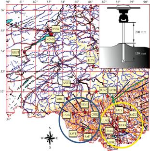
The period of more than twenty years in which recent movements in the Mountainous Altai were measured by methods of satellite geodesy includes various phases of the seismic process. A network consisting of 20 observing stations extends over a large area from Novosibirsk City in the north to the Mongolian border in the south, from the border with Kazakhstan in the west to the Sayan Mountains in the east. The Chuya earthquake of September 2003 divides, in a natural manner, the period of observation from 2000 to 2022 into several phases: the preseismic (2000‒2003), the coseismic (2003‒2004), the postseismic phase for the epicentral area of the Chuya earthquake (2004‒2013), and the interseismic phase for the other regions of the Mountainous Altai that have not been seriously affected by the earthquake (2000‒2022). The data supplied by multiyear measurements were analyzed using special programs of the most recent modifications. We have identified conspicuous features in the displacement fields during each phase: anomalous displacement rates before the Chuya earthquake, the coseismic displacements during the earthquake, postseismic effects in the epicentral zone, and slow tectonic movements. Our interpretation relied on 2D and 3D elastic and viscoelastic models of the crust. The depth of focus has been determined (14 km), as well as the two-meter relative right lateral displacement jump on the seismic fault. With a two-layered model, we obtained the value of viscosity in the lower crust for a variety of elastic modulus values η = 5 × 10¹⁹‒1.1 × 10²⁰ Pa s. The recent movements in that part of the Mountainous Altai which has not been affected by the Chuya earthquake were 0.8 mm/yr toward NNW. The rate of surface deformation in the southern mountainous part reached 2 × 10⁻⁸/yr in the epoch 2000‒2022, which is an order of magnitude higher than that in the northern flat part of the area of study.
期刊介绍:
Journal of Volcanology and Seismology publishes theoretical and experimental studies, communications, and reports on volcanic, seismic, geodynamic, and magmatic processes occurring in the areas of island arcs and other active regions of the Earth. In particular, the journal looks at present-day land and submarine volcanic activity; Neogene–Quaternary volcanism; mechanisms of plutonic activity; the geochemistry of volcanic and postvolcanic processes; geothermal systems in volcanic regions; and seismological monitoring. In addition, the journal surveys earthquakes, volcanic eruptions, and techniques for predicting them.


 分享
分享
 求助内容:
求助内容: 应助结果提醒方式:
 扫码关注我们
