V. N. Zinko, A. M. Korzhenkov, A. N. Ovsyuchenko, D. E. Edemsky, A. S. Larkov, A. I. Sysolin
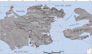
{"title":"The South Churubash Settlement, Eastern Crimea: Earthquake-Induced Gravitational and Inertial Deformations","authors":"V. N. Zinko, A. M. Korzhenkov, A. N. Ovsyuchenko, D. E. Edemsky, A. S. Larkov, A. I. Sysolin","doi":"10.1134/S0742046324700647","DOIUrl":null,"url":null,"abstract":"<p>This study reports comprehensive research (archeological, archaeo- and paleo-seismological, as well as georadar profiling), which enabled us to find out the cause of destruction for the South Churubash settlement (a big manor in the chora around the town of Nymphaion) in eastern Crimea. A strong seismic event whose possible rupture went along the southwestern boundary of the Churubash Liman, which is a segment of the Parpach–Taman active fault, led to the formation of landslide bodies southwest of the rupture. The nearly north–south plane of scar for one of these has traversed the ancient settlement through its middle, having produced a visible flexure in the juvenile soil of this archeological monument—an earthquake-induced gravitational deformation. Large seismic slip at the fault plane had destroyed all structures and led to large deformations in the lower rows of the masonry: tilts, shifts, and rotations of parts of the walls—earthquake-induced inertial deformations. Considering that the earthquake rupture was nearby, and that all houses have been destroyed in the settlement, we hypothesize that the manor was caught in the epicentral zone of an ancient earthquake where the intensity of seismic motion was at least Io ≥ IX. Judging by the findings of amphorae brands, black glazed pottery, as well as of a Bosporus coin, this large manor in the chora of Nymphaion came to the end of its existence owing to a strong earthquake and a fire in the beginning of the fourth quarter of the 4th century BC. We may have previously observed traces of this earthquake in Nymphaion: as an example, the structures of Nymphaion dating back to the 5th—4th centuries BC had been completely or partly destroyed. Further surveys of active geological structures and archeological monuments would enable a more accurate parameterization of the seismic event identified in this study, which would serve the purpose of a more accurate assessment of earthquake hazard for the Crimean Peninsula.</p>","PeriodicalId":56112,"journal":{"name":"Journal of Volcanology and Seismology","volume":"18 4","pages":"366 - 382"},"PeriodicalIF":0.9000,"publicationDate":"2024-08-21","publicationTypes":"Journal Article","fieldsOfStudy":null,"isOpenAccess":false,"openAccessPdf":"","citationCount":"0","resultStr":null,"platform":"Semanticscholar","paperid":null,"PeriodicalName":"Journal of Volcanology and Seismology","FirstCategoryId":"89","ListUrlMain":"https://link.springer.com/article/10.1134/S0742046324700647","RegionNum":4,"RegionCategory":"地球科学","ArticlePicture":[],"TitleCN":null,"AbstractTextCN":null,"PMCID":null,"EPubDate":"","PubModel":"","JCR":"Q4","JCRName":"GEOCHEMISTRY & GEOPHYSICS","Score":null,"Total":0}
引用次数: 0
Abstract
This study reports comprehensive research (archeological, archaeo- and paleo-seismological, as well as georadar profiling), which enabled us to find out the cause of destruction for the South Churubash settlement (a big manor in the chora around the town of Nymphaion) in eastern Crimea. A strong seismic event whose possible rupture went along the southwestern boundary of the Churubash Liman, which is a segment of the Parpach–Taman active fault, led to the formation of landslide bodies southwest of the rupture. The nearly north–south plane of scar for one of these has traversed the ancient settlement through its middle, having produced a visible flexure in the juvenile soil of this archeological monument—an earthquake-induced gravitational deformation. Large seismic slip at the fault plane had destroyed all structures and led to large deformations in the lower rows of the masonry: tilts, shifts, and rotations of parts of the walls—earthquake-induced inertial deformations. Considering that the earthquake rupture was nearby, and that all houses have been destroyed in the settlement, we hypothesize that the manor was caught in the epicentral zone of an ancient earthquake where the intensity of seismic motion was at least Io ≥ IX. Judging by the findings of amphorae brands, black glazed pottery, as well as of a Bosporus coin, this large manor in the chora of Nymphaion came to the end of its existence owing to a strong earthquake and a fire in the beginning of the fourth quarter of the 4th century BC. We may have previously observed traces of this earthquake in Nymphaion: as an example, the structures of Nymphaion dating back to the 5th—4th centuries BC had been completely or partly destroyed. Further surveys of active geological structures and archeological monuments would enable a more accurate parameterization of the seismic event identified in this study, which would serve the purpose of a more accurate assessment of earthquake hazard for the Crimean Peninsula.
期刊介绍:
Journal of Volcanology and Seismology publishes theoretical and experimental studies, communications, and reports on volcanic, seismic, geodynamic, and magmatic processes occurring in the areas of island arcs and other active regions of the Earth. In particular, the journal looks at present-day land and submarine volcanic activity; Neogene–Quaternary volcanism; mechanisms of plutonic activity; the geochemistry of volcanic and postvolcanic processes; geothermal systems in volcanic regions; and seismological monitoring. In addition, the journal surveys earthquakes, volcanic eruptions, and techniques for predicting them.


 分享
分享
 求助内容:
求助内容: 应助结果提醒方式:
 扫码关注我们
