Hui Chen, Ziming Wu, Zihui Sun, Ning Yang, Muhammad llyas Menhas, Bilal Ahmad
{"title":"CsdlFusion: An Infrared and Visible Image Fusion Method Based on LatLRR-NSST and Compensated Saliency Detection","authors":"Hui Chen, Ziming Wu, Zihui Sun, Ning Yang, Muhammad llyas Menhas, Bilal Ahmad","doi":"10.1007/s12524-024-01987-y","DOIUrl":null,"url":null,"abstract":"<p>Image fusion methods may lose their ability to retain crucial image information when faced with suboptimal conditions, such as poor contrast, excessive noise, or intense illumination, leading to the loss of valuable image features. In this work, an improved CsdFusion algorithm is proposed to increase the visibility of infrared targets in fused images. Firstly, to accomplish clear background textures and structural information, a hybrid image decomposition model combining LatLRR and NSST is established. This process entails the division of the original infrared and visible images into low-rank components (base layers) and salient components (saliency layers) through the Latent Low-Rank Representation (LatLRR) approach. Subsequently, the base layers of both the infrared and visible images undergo the Non-Subsampled Shearlet Transform (NSST), decomposing them into high-frequency and low-frequency layers. The processed high-frequency and low-frequency layers are then subjected to inverse NSST to obtain the fused base layer, ensuring that the fused image retains maximum background information while effectively filtering noise. Secondly, to identify and extract the most significant regions or features in infrared images, the Central-contrast priori Saliency Map (CSM) algorithm is applied. This algorithm calculates the central prior saliency value using Harris corners and the contrast prior saliency value using guided filtering and background suppression. It then combines these two prior saliency values using a feature compensation strategy to compute the infrared saliency map. To validate the effectiveness of the proposed algorithm, comparative evaluation studies on benchmark open datasets are carried out. The results thus obtained through the proposed algorithm demonstrate superior performance in both subjective and objective experiments, generating fused images that not only preserve the crucial details and characteristics of both infrared and visible images but also reflect significant enhancement in visibility and discriminability of target objects, outperforming 10 state-of-the-art image fusion algorithms.</p>","PeriodicalId":17510,"journal":{"name":"Journal of the Indian Society of Remote Sensing","volume":"79 1","pages":""},"PeriodicalIF":2.2000,"publicationDate":"2024-08-24","publicationTypes":"Journal Article","fieldsOfStudy":null,"isOpenAccess":false,"openAccessPdf":"","citationCount":"0","resultStr":null,"platform":"Semanticscholar","paperid":null,"PeriodicalName":"Journal of the Indian Society of Remote Sensing","FirstCategoryId":"5","ListUrlMain":"https://doi.org/10.1007/s12524-024-01987-y","RegionNum":4,"RegionCategory":"地球科学","ArticlePicture":[],"TitleCN":null,"AbstractTextCN":null,"PMCID":null,"EPubDate":"","PubModel":"","JCR":"Q3","JCRName":"ENVIRONMENTAL SCIENCES","Score":null,"Total":0}
引用次数: 0
Abstract
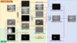
Image fusion methods may lose their ability to retain crucial image information when faced with suboptimal conditions, such as poor contrast, excessive noise, or intense illumination, leading to the loss of valuable image features. In this work, an improved CsdFusion algorithm is proposed to increase the visibility of infrared targets in fused images. Firstly, to accomplish clear background textures and structural information, a hybrid image decomposition model combining LatLRR and NSST is established. This process entails the division of the original infrared and visible images into low-rank components (base layers) and salient components (saliency layers) through the Latent Low-Rank Representation (LatLRR) approach. Subsequently, the base layers of both the infrared and visible images undergo the Non-Subsampled Shearlet Transform (NSST), decomposing them into high-frequency and low-frequency layers. The processed high-frequency and low-frequency layers are then subjected to inverse NSST to obtain the fused base layer, ensuring that the fused image retains maximum background information while effectively filtering noise. Secondly, to identify and extract the most significant regions or features in infrared images, the Central-contrast priori Saliency Map (CSM) algorithm is applied. This algorithm calculates the central prior saliency value using Harris corners and the contrast prior saliency value using guided filtering and background suppression. It then combines these two prior saliency values using a feature compensation strategy to compute the infrared saliency map. To validate the effectiveness of the proposed algorithm, comparative evaluation studies on benchmark open datasets are carried out. The results thus obtained through the proposed algorithm demonstrate superior performance in both subjective and objective experiments, generating fused images that not only preserve the crucial details and characteristics of both infrared and visible images but also reflect significant enhancement in visibility and discriminability of target objects, outperforming 10 state-of-the-art image fusion algorithms.
期刊介绍:
The aims and scope of the Journal of the Indian Society of Remote Sensing are to help towards advancement, dissemination and application of the knowledge of Remote Sensing technology, which is deemed to include photo interpretation, photogrammetry, aerial photography, image processing, and other related technologies in the field of survey, planning and management of natural resources and other areas of application where the technology is considered to be appropriate, to promote interaction among all persons, bodies, institutions (private and/or state-owned) and industries interested in achieving advancement, dissemination and application of the technology, to encourage and undertake research in remote sensing and related technologies and to undertake and execute all acts which shall promote all or any of the aims and objectives of the Indian Society of Remote Sensing.


 分享
分享
 求助内容:
求助内容: 应助结果提醒方式:
 扫码关注我们
