P. Srikanth, Anima Biswal, Bhavana Sahay, V. M. Chowdary, K. Sreenivas, Prakash Chauhan
{"title":"Mapping of Kharif Sown Area Using Temporal RISAT-1A SAR and Optical Data","authors":"P. Srikanth, Anima Biswal, Bhavana Sahay, V. M. Chowdary, K. Sreenivas, Prakash Chauhan","doi":"10.1007/s12524-024-01977-0","DOIUrl":null,"url":null,"abstract":"<p>Timely and accurate information on crop-sown areas during the <i>kharif</i> season (monsoon season in India) is crucial for early identification of drought-prone areas, enabling prompt intervention and mitigation measures to minimize adverse effects on crops and farmers. In this study, two approaches were attempted to estimate the in-season <i>kharif</i> sown area by the end of August using EOS-04 (RISAT-1A) data. Approach 1 utilizes the Coefficient of Variation (CV) of temporal Synthetic Aperture Radar (SAR) backscatter, while Approach 2 integrates optical data with the CV of SAR backscatter. The algorithm based on the temporal CV suggested that the variability of backscatter values over time, captured through temporal analysis, can be a key factor in identifying and delineating cropland areas. The CV of temporal HV backscatter data serves as an indicator of changes in vegetation cover or crop growth stages. In this study, CV values for settlement, forest, and fallow areas were observed to be 0.18, 0.17, and 0.19, respectively, while crops exhibited higher CV values of more than 0.4, which can be attributed to active crop growth. CV threshold optimization was carried out using Youden’s J Score statistical method. The optimal CV threshold value was observed to be 0.3, computed based on the temporal HV backscatter data from four study districts, which was further validated over two other districts. Accuracies of around 80% were achieved in both test and validation districts using the SAR only approach. Integration of optical data with SAR data led to improved overall accuracies, ranging from 85 to 89% in all test and validation districts. The findings suggest that CV analysis of backscatter values, complemented with optical data, can be a valuable tool for early discrimination between different land cover features, with croplands standing out due to their higher CV values attributed to the dynamic nature of crop growth. Using Youden’s J Score for threshold optimization adds statistical rigor to the methodology and demonstrates its potential for accurate in-season <i>kharif</i> sown area estimation for its operational use over large areas.</p>","PeriodicalId":17510,"journal":{"name":"Journal of the Indian Society of Remote Sensing","volume":"33 1","pages":""},"PeriodicalIF":2.2000,"publicationDate":"2024-08-25","publicationTypes":"Journal Article","fieldsOfStudy":null,"isOpenAccess":false,"openAccessPdf":"","citationCount":"0","resultStr":null,"platform":"Semanticscholar","paperid":null,"PeriodicalName":"Journal of the Indian Society of Remote Sensing","FirstCategoryId":"5","ListUrlMain":"https://doi.org/10.1007/s12524-024-01977-0","RegionNum":4,"RegionCategory":"地球科学","ArticlePicture":[],"TitleCN":null,"AbstractTextCN":null,"PMCID":null,"EPubDate":"","PubModel":"","JCR":"Q3","JCRName":"ENVIRONMENTAL SCIENCES","Score":null,"Total":0}
引用次数: 0
Abstract
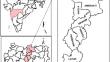
Timely and accurate information on crop-sown areas during the kharif season (monsoon season in India) is crucial for early identification of drought-prone areas, enabling prompt intervention and mitigation measures to minimize adverse effects on crops and farmers. In this study, two approaches were attempted to estimate the in-season kharif sown area by the end of August using EOS-04 (RISAT-1A) data. Approach 1 utilizes the Coefficient of Variation (CV) of temporal Synthetic Aperture Radar (SAR) backscatter, while Approach 2 integrates optical data with the CV of SAR backscatter. The algorithm based on the temporal CV suggested that the variability of backscatter values over time, captured through temporal analysis, can be a key factor in identifying and delineating cropland areas. The CV of temporal HV backscatter data serves as an indicator of changes in vegetation cover or crop growth stages. In this study, CV values for settlement, forest, and fallow areas were observed to be 0.18, 0.17, and 0.19, respectively, while crops exhibited higher CV values of more than 0.4, which can be attributed to active crop growth. CV threshold optimization was carried out using Youden’s J Score statistical method. The optimal CV threshold value was observed to be 0.3, computed based on the temporal HV backscatter data from four study districts, which was further validated over two other districts. Accuracies of around 80% were achieved in both test and validation districts using the SAR only approach. Integration of optical data with SAR data led to improved overall accuracies, ranging from 85 to 89% in all test and validation districts. The findings suggest that CV analysis of backscatter values, complemented with optical data, can be a valuable tool for early discrimination between different land cover features, with croplands standing out due to their higher CV values attributed to the dynamic nature of crop growth. Using Youden’s J Score for threshold optimization adds statistical rigor to the methodology and demonstrates its potential for accurate in-season kharif sown area estimation for its operational use over large areas.
期刊介绍:
The aims and scope of the Journal of the Indian Society of Remote Sensing are to help towards advancement, dissemination and application of the knowledge of Remote Sensing technology, which is deemed to include photo interpretation, photogrammetry, aerial photography, image processing, and other related technologies in the field of survey, planning and management of natural resources and other areas of application where the technology is considered to be appropriate, to promote interaction among all persons, bodies, institutions (private and/or state-owned) and industries interested in achieving advancement, dissemination and application of the technology, to encourage and undertake research in remote sensing and related technologies and to undertake and execute all acts which shall promote all or any of the aims and objectives of the Indian Society of Remote Sensing.


 分享
分享
 求助内容:
求助内容: 应助结果提醒方式:
 扫码关注我们
