{"title":"Volcanic Eruptions and Tectonic Activity of Aitken Crater: Implications for SPA and Farside Volcanism of the Moon","authors":"A. V. Satyakumar, B. B. Deepak","doi":"10.1007/s12524-024-01979-y","DOIUrl":null,"url":null,"abstract":"<p>An extensive investigation is conducted using remote sensing and gravity datasets to comprehend the volcanic eruptions and tectonic activity within the Aitken crater, farside of the Moon. M<sup>3</sup> analyses indicate that the mare region dominates the clinopyroxene and represents the basaltic nature. The southern part of the crater floor exhibits enhanced FeO (11–15 wt%) and TiO<sub>2</sub> (2–5 wt%) percentages, indicating mare basalt material in conjunction with the spectral data. We observed intense mass-wasting features, various small-scale tectonic and volcanic structures on the crater walls and floor. We found lobate scarps near the mare basalts; however, the thickness of the mare basalts is low; therefore, there was not much subsidence and contraction produced by the mare basalts. As a result, the lobate scarps in the mare basalts of Aitken were probably caused by the Moon's thermal contraction. The GRAIL gravity anomalies indicate the existence of deep-seated subsurface material (i.e., magmatism that caused the mare to form on the crater floor) and a thick crust (30–40 km). Based on these integrated (compositional, morphological, and gravity) observations, we conclude that the floor of the crater is probably volcanic in origin, and the walls of the crater formed due to the impact melt crystallization. The wrinkle ridges that cut across minor impact craters and volcanic domes, horseshoe-shaped depressions, lobate scarps, and well-preserved dome structures indicate crater modification in later stages due to volcanic and tectonic activity. The eruptive activity in Aitken most likely began with an explosive cone-building stage, continued with lava eruptions from cones and fissures, and ended with a drain limited to the relatively deep lava ponded in the vents. Future research and analysis of the Aitken crater is particularly attractive because of its combination of impact and volcanic features.</p>","PeriodicalId":17510,"journal":{"name":"Journal of the Indian Society of Remote Sensing","volume":"50 1","pages":""},"PeriodicalIF":2.2000,"publicationDate":"2024-08-27","publicationTypes":"Journal Article","fieldsOfStudy":null,"isOpenAccess":false,"openAccessPdf":"","citationCount":"0","resultStr":null,"platform":"Semanticscholar","paperid":null,"PeriodicalName":"Journal of the Indian Society of Remote Sensing","FirstCategoryId":"5","ListUrlMain":"https://doi.org/10.1007/s12524-024-01979-y","RegionNum":4,"RegionCategory":"地球科学","ArticlePicture":[],"TitleCN":null,"AbstractTextCN":null,"PMCID":null,"EPubDate":"","PubModel":"","JCR":"Q3","JCRName":"ENVIRONMENTAL SCIENCES","Score":null,"Total":0}
引用次数: 0
Abstract
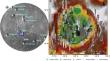
An extensive investigation is conducted using remote sensing and gravity datasets to comprehend the volcanic eruptions and tectonic activity within the Aitken crater, farside of the Moon. M3 analyses indicate that the mare region dominates the clinopyroxene and represents the basaltic nature. The southern part of the crater floor exhibits enhanced FeO (11–15 wt%) and TiO2 (2–5 wt%) percentages, indicating mare basalt material in conjunction with the spectral data. We observed intense mass-wasting features, various small-scale tectonic and volcanic structures on the crater walls and floor. We found lobate scarps near the mare basalts; however, the thickness of the mare basalts is low; therefore, there was not much subsidence and contraction produced by the mare basalts. As a result, the lobate scarps in the mare basalts of Aitken were probably caused by the Moon's thermal contraction. The GRAIL gravity anomalies indicate the existence of deep-seated subsurface material (i.e., magmatism that caused the mare to form on the crater floor) and a thick crust (30–40 km). Based on these integrated (compositional, morphological, and gravity) observations, we conclude that the floor of the crater is probably volcanic in origin, and the walls of the crater formed due to the impact melt crystallization. The wrinkle ridges that cut across minor impact craters and volcanic domes, horseshoe-shaped depressions, lobate scarps, and well-preserved dome structures indicate crater modification in later stages due to volcanic and tectonic activity. The eruptive activity in Aitken most likely began with an explosive cone-building stage, continued with lava eruptions from cones and fissures, and ended with a drain limited to the relatively deep lava ponded in the vents. Future research and analysis of the Aitken crater is particularly attractive because of its combination of impact and volcanic features.
期刊介绍:
The aims and scope of the Journal of the Indian Society of Remote Sensing are to help towards advancement, dissemination and application of the knowledge of Remote Sensing technology, which is deemed to include photo interpretation, photogrammetry, aerial photography, image processing, and other related technologies in the field of survey, planning and management of natural resources and other areas of application where the technology is considered to be appropriate, to promote interaction among all persons, bodies, institutions (private and/or state-owned) and industries interested in achieving advancement, dissemination and application of the technology, to encourage and undertake research in remote sensing and related technologies and to undertake and execute all acts which shall promote all or any of the aims and objectives of the Indian Society of Remote Sensing.


 分享
分享
 求助内容:
求助内容: 应助结果提醒方式:
 扫码关注我们
