Xiaoning Su , Qinghua Bao , Zhiyu Gao , Jiale Huang
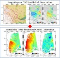
{"title":"Three-dimensional interseismic crustal deformation in the northeastern margin of the Tibetan Plateau using GNSS and InSAR","authors":"Xiaoning Su , Qinghua Bao , Zhiyu Gao , Jiale Huang","doi":"10.1016/j.jseaes.2024.106328","DOIUrl":null,"url":null,"abstract":"<div><p>The nature of the crustal deformation of the northeastern margin of the Tibetan Plateau is vital for elucidating the expansion mechanism of the plateau. We installed 21 continuous GNSS stations and obtained a horizontal velocity field with high spatial resolution. We also acquired a line-of-sight(LOS)<!--> <!-->velocity field with Sentinel-1 images covering the study area from 2014 to 2022. A multi-scale spherical wavelet method was employed to unify the reference frames of GNSS and InSAR data. After unifying the reference frame, the two data types achieve high consistency. Combining GNSS and InSAR velocities yielded the three-dimensional interseismic velocity field in the northeastern margin of the Tibetan Plateau. Furthermore, we analyzed the crustal deformation characteristics based on the three-dimensional deformation field. The crustal deformation exhibits a pronounced northeastward shift relative to the Ordos block, whereas the interior of the Ordos block remains remarkably stationary, behaving as a rigid unit. The Liupanshan fault is primarily characterized by uplift, devoid of any notable horizontal deformation across the fault. The left-lateral strike-slip mainly characterizes the Haiyuan fault.. The maximum east–west deformation velocity on the southern side of the fault is approximately 3.9 mm/yr, decreasing to about 1.0 mm/yr at the eastern end of the fault. The western segment of the West Qinling fault exhibits a minor east–west motion. Our result provides essential data for further study of the crustal deformation patterns.</p></div>","PeriodicalId":50253,"journal":{"name":"Journal of Asian Earth Sciences","volume":"276 ","pages":"Article 106328"},"PeriodicalIF":2.4000,"publicationDate":"2024-12-01","publicationTypes":"Journal Article","fieldsOfStudy":null,"isOpenAccess":false,"openAccessPdf":"https://www.sciencedirect.com/science/article/pii/S1367912024003237/pdfft?md5=afaa7fcb72a41ff8ff75955ed46919ec&pid=1-s2.0-S1367912024003237-main.pdf","citationCount":"0","resultStr":null,"platform":"Semanticscholar","paperid":null,"PeriodicalName":"Journal of Asian Earth Sciences","FirstCategoryId":"89","ListUrlMain":"https://www.sciencedirect.com/science/article/pii/S1367912024003237","RegionNum":3,"RegionCategory":"地球科学","ArticlePicture":[],"TitleCN":null,"AbstractTextCN":null,"PMCID":null,"EPubDate":"2024/9/11 0:00:00","PubModel":"Epub","JCR":"Q2","JCRName":"GEOSCIENCES, MULTIDISCIPLINARY","Score":null,"Total":0}
引用次数: 0
Abstract
The nature of the crustal deformation of the northeastern margin of the Tibetan Plateau is vital for elucidating the expansion mechanism of the plateau. We installed 21 continuous GNSS stations and obtained a horizontal velocity field with high spatial resolution. We also acquired a line-of-sight(LOS) velocity field with Sentinel-1 images covering the study area from 2014 to 2022. A multi-scale spherical wavelet method was employed to unify the reference frames of GNSS and InSAR data. After unifying the reference frame, the two data types achieve high consistency. Combining GNSS and InSAR velocities yielded the three-dimensional interseismic velocity field in the northeastern margin of the Tibetan Plateau. Furthermore, we analyzed the crustal deformation characteristics based on the three-dimensional deformation field. The crustal deformation exhibits a pronounced northeastward shift relative to the Ordos block, whereas the interior of the Ordos block remains remarkably stationary, behaving as a rigid unit. The Liupanshan fault is primarily characterized by uplift, devoid of any notable horizontal deformation across the fault. The left-lateral strike-slip mainly characterizes the Haiyuan fault.. The maximum east–west deformation velocity on the southern side of the fault is approximately 3.9 mm/yr, decreasing to about 1.0 mm/yr at the eastern end of the fault. The western segment of the West Qinling fault exhibits a minor east–west motion. Our result provides essential data for further study of the crustal deformation patterns.
期刊介绍:
Journal of Asian Earth Sciences has an open access mirror journal Journal of Asian Earth Sciences: X, sharing the same aims and scope, editorial team, submission system and rigorous peer review.
The Journal of Asian Earth Sciences is an international interdisciplinary journal devoted to all aspects of research related to the solid Earth Sciences of Asia. The Journal publishes high quality, peer-reviewed scientific papers on the regional geology, tectonics, geochemistry and geophysics of Asia. It will be devoted primarily to research papers but short communications relating to new developments of broad interest, reviews and book reviews will also be included. Papers must have international appeal and should present work of more than local significance.
The scope includes deep processes of the Asian continent and its adjacent oceans; seismology and earthquakes; orogeny, magmatism, metamorphism and volcanism; growth, deformation and destruction of the Asian crust; crust-mantle interaction; evolution of life (early life, biostratigraphy, biogeography and mass-extinction); fluids, fluxes and reservoirs of mineral and energy resources; surface processes (weathering, erosion, transport and deposition of sediments) and resulting geomorphology; and the response of the Earth to global climate change as viewed within the Asian continent and surrounding oceans.


 分享
分享
 求助内容:
求助内容: 应助结果提醒方式:
 扫码关注我们
