Application of ML- based approach for co-seismic landslides susceptibility mapping and identification of important controlling factors in eastern Himalayan region
{"title":"Application of ML- based approach for co-seismic landslides susceptibility mapping and identification of important controlling factors in eastern Himalayan region","authors":"Saurav Kumar, Aniruddha Sengupta","doi":"10.1007/s12665-024-11911-9","DOIUrl":null,"url":null,"abstract":"<div><p>Co-seismic landslides pose a significant concern for the Himalayas and its nearby area due to high seismic activity in the region, coupled with steep slopes and heavy rainfall, responsible for substantial socioeconomic losses. Accurate and reliable Co-seismic landslide susceptibility maps are vital in highlighting high-risk zones where proactive measures can be taken to minimise the risk. Despite numerous machine learning (ML) models and landslide controlling factors being explored for susceptibility mapping, uncertainty remains about removing irrelevant factors and identifying optimal controlling factors for an ML based model. Further earlier research highlights that the performance of ML based models improves when optimal controlling factors are utilized for training the model. This study aims to evaluate the efficiency of Random Forest (RF), Logistic Regression (LR), and Naive Bayes (NB) for co-seismic landslide susceptibility mapping and identifying most important controlling factors in the eastern Himalayan region. The landslide inventory of the 2011 Mw 6.9 Sikkim earthquake and a spatial database comprising 16 landslide-controlling factors have been utilised. A novel approach is proposed for selecting the optimal controlling factors for an ML model. Susceptibility maps for the Indian state of Sikkim are prepared by each model using optimal controlling factors. Peak Ground Acceleration (PGA), river distance, slope, fault distance, and elevation are identified as the most important factors, with the RF model showing superior performance. The outcomes of this study provide valuable insights for policymakers and engineers for land use planning and proactive measures to minimize losses.</p></div>","PeriodicalId":542,"journal":{"name":"Environmental Earth Sciences","volume":"83 21","pages":""},"PeriodicalIF":2.8000,"publicationDate":"2024-10-21","publicationTypes":"Journal Article","fieldsOfStudy":null,"isOpenAccess":false,"openAccessPdf":"","citationCount":"0","resultStr":null,"platform":"Semanticscholar","paperid":null,"PeriodicalName":"Environmental Earth Sciences","FirstCategoryId":"93","ListUrlMain":"https://link.springer.com/article/10.1007/s12665-024-11911-9","RegionNum":4,"RegionCategory":"环境科学与生态学","ArticlePicture":[],"TitleCN":null,"AbstractTextCN":null,"PMCID":null,"EPubDate":"","PubModel":"","JCR":"Q3","JCRName":"ENVIRONMENTAL SCIENCES","Score":null,"Total":0}
引用次数: 0
Abstract
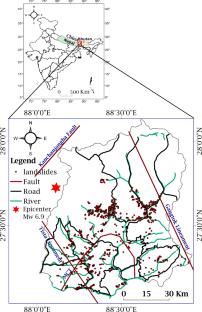
Co-seismic landslides pose a significant concern for the Himalayas and its nearby area due to high seismic activity in the region, coupled with steep slopes and heavy rainfall, responsible for substantial socioeconomic losses. Accurate and reliable Co-seismic landslide susceptibility maps are vital in highlighting high-risk zones where proactive measures can be taken to minimise the risk. Despite numerous machine learning (ML) models and landslide controlling factors being explored for susceptibility mapping, uncertainty remains about removing irrelevant factors and identifying optimal controlling factors for an ML based model. Further earlier research highlights that the performance of ML based models improves when optimal controlling factors are utilized for training the model. This study aims to evaluate the efficiency of Random Forest (RF), Logistic Regression (LR), and Naive Bayes (NB) for co-seismic landslide susceptibility mapping and identifying most important controlling factors in the eastern Himalayan region. The landslide inventory of the 2011 Mw 6.9 Sikkim earthquake and a spatial database comprising 16 landslide-controlling factors have been utilised. A novel approach is proposed for selecting the optimal controlling factors for an ML model. Susceptibility maps for the Indian state of Sikkim are prepared by each model using optimal controlling factors. Peak Ground Acceleration (PGA), river distance, slope, fault distance, and elevation are identified as the most important factors, with the RF model showing superior performance. The outcomes of this study provide valuable insights for policymakers and engineers for land use planning and proactive measures to minimize losses.
期刊介绍:
Environmental Earth Sciences is an international multidisciplinary journal concerned with all aspects of interaction between humans, natural resources, ecosystems, special climates or unique geographic zones, and the earth:
Water and soil contamination caused by waste management and disposal practices
Environmental problems associated with transportation by land, air, or water
Geological processes that may impact biosystems or humans
Man-made or naturally occurring geological or hydrological hazards
Environmental problems associated with the recovery of materials from the earth
Environmental problems caused by extraction of minerals, coal, and ores, as well as oil and gas, water and alternative energy sources
Environmental impacts of exploration and recultivation – Environmental impacts of hazardous materials
Management of environmental data and information in data banks and information systems
Dissemination of knowledge on techniques, methods, approaches and experiences to improve and remediate the environment
In pursuit of these topics, the geoscientific disciplines are invited to contribute their knowledge and experience. Major disciplines include: hydrogeology, hydrochemistry, geochemistry, geophysics, engineering geology, remediation science, natural resources management, environmental climatology and biota, environmental geography, soil science and geomicrobiology.


 分享
分享
 求助内容:
求助内容: 应助结果提醒方式:
 扫码关注我们
