Matthew Jordan, Jim Vafidis, Mark Steer, Kathy Fawcett, Kathy Meakin, Gareth Parry, Matthew Brown
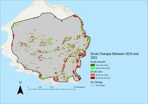
{"title":"Measuring Temporal Change in Scrub Vegetation Cover Using UAV-Derived Height Maps: A Case Study at Two UK Nature Reserves","authors":"Matthew Jordan, Jim Vafidis, Mark Steer, Kathy Fawcett, Kathy Meakin, Gareth Parry, Matthew Brown","doi":"10.1002/ece3.70463","DOIUrl":null,"url":null,"abstract":"<p>Measuring the outcome of practical interventions and actions helps to inform conservation management objectives and assess progress towards objectives and targets. Measuring success also informs future management by identifying actions that are effective and those that are not. Scrub vegetation is an important habitat type in terrestrial ecosystems, providing important shelter and food resources for biodiversity and livestock. Much of practical land management in the UK involves the monitoring and management of scrub, and current drone-based methods of scrub collection requires expensive equipment or complex methods. A 2021 paper determined a cheap and simple way to determine scrub levels, and this could potentially be used to map temporal changes, as well as identify directional change in scrub. This study looks at whether the method outlined in the 2021 study could be used to measure temporal and directional changes in scrub cover on two nature reserves in the UK: Daneway Banks in Gloucestershire and Flat Holm Island in the Severn Estuary. Scrub levels at Daneway Banks increased from 14.63% in 2015 to 16.52% in 2017, before decreasing to 14.89% in 2021 due to managed cutting and clearing. Scrub cover at Flatholm Island decreased from 10.18% in 2019 to 8.71% in 2021. The exact locations of scrub growth and loss for each site was also calculated and mapped. This approach was found to be a viable way of measuring temporal and directional change in scrub levels. The data can also be used to reframe changes in scrub levels as a shift towards vegetation succession or reduction, to better visualise how changes in scrub levels affect overall site management goals, and is a cheaper, more accessible alternative to current methods of measuring temporal vegetation changes.</p>","PeriodicalId":11467,"journal":{"name":"Ecology and Evolution","volume":"14 10","pages":""},"PeriodicalIF":2.3000,"publicationDate":"2024-10-22","publicationTypes":"Journal Article","fieldsOfStudy":null,"isOpenAccess":false,"openAccessPdf":"https://www.ncbi.nlm.nih.gov/pmc/articles/PMC11495879/pdf/","citationCount":"0","resultStr":null,"platform":"Semanticscholar","paperid":null,"PeriodicalName":"Ecology and Evolution","FirstCategoryId":"99","ListUrlMain":"https://onlinelibrary.wiley.com/doi/10.1002/ece3.70463","RegionNum":2,"RegionCategory":"生物学","ArticlePicture":[],"TitleCN":null,"AbstractTextCN":null,"PMCID":null,"EPubDate":"","PubModel":"","JCR":"Q2","JCRName":"ECOLOGY","Score":null,"Total":0}
引用次数: 0
Abstract
Measuring the outcome of practical interventions and actions helps to inform conservation management objectives and assess progress towards objectives and targets. Measuring success also informs future management by identifying actions that are effective and those that are not. Scrub vegetation is an important habitat type in terrestrial ecosystems, providing important shelter and food resources for biodiversity and livestock. Much of practical land management in the UK involves the monitoring and management of scrub, and current drone-based methods of scrub collection requires expensive equipment or complex methods. A 2021 paper determined a cheap and simple way to determine scrub levels, and this could potentially be used to map temporal changes, as well as identify directional change in scrub. This study looks at whether the method outlined in the 2021 study could be used to measure temporal and directional changes in scrub cover on two nature reserves in the UK: Daneway Banks in Gloucestershire and Flat Holm Island in the Severn Estuary. Scrub levels at Daneway Banks increased from 14.63% in 2015 to 16.52% in 2017, before decreasing to 14.89% in 2021 due to managed cutting and clearing. Scrub cover at Flatholm Island decreased from 10.18% in 2019 to 8.71% in 2021. The exact locations of scrub growth and loss for each site was also calculated and mapped. This approach was found to be a viable way of measuring temporal and directional change in scrub levels. The data can also be used to reframe changes in scrub levels as a shift towards vegetation succession or reduction, to better visualise how changes in scrub levels affect overall site management goals, and is a cheaper, more accessible alternative to current methods of measuring temporal vegetation changes.
期刊介绍:
Ecology and Evolution is the peer reviewed journal for rapid dissemination of research in all areas of ecology, evolution and conservation science. The journal gives priority to quality research reports, theoretical or empirical, that develop our understanding of organisms and their diversity, interactions between them, and the natural environment.
Ecology and Evolution gives prompt and equal consideration to papers reporting theoretical, experimental, applied and descriptive work in terrestrial and aquatic environments. The journal will consider submissions across taxa in areas including but not limited to micro and macro ecological and evolutionary processes, characteristics of and interactions between individuals, populations, communities and the environment, physiological responses to environmental change, population genetics and phylogenetics, relatedness and kin selection, life histories, systematics and taxonomy, conservation genetics, extinction, speciation, adaption, behaviour, biodiversity, species abundance, macroecology, population and ecosystem dynamics, and conservation policy.


 分享
分享
 求助内容:
求助内容: 应助结果提醒方式:
 扫码关注我们
