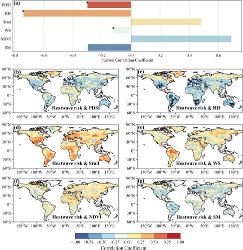
Heatwaves represent a significant and growing threat to natural ecosystems and socio-economic structures, making heatwave risk mitigation and prevention an important area of research. In exploring heatwave frequency and intensity from 1901 to 2020, the present study finds a sharp increase in both. The study also finds that the spatial distribution of heatwaves is unequal, the volatility of intensity characteristics has become more prominent over time, and the Gini coefficients of four key heatwave indictors have become larger due to increasing dryness. Although heatwaves occur more frequently in drylands, there is greater cumulative heat in humid areas, resulting in a higher heatwave risk in those areas. The global heatwave risk over the past three decades (1991–2020) has increased nearly five-fold compared to the early 20th century (1901–1930). Furthermore, GeoDetector analysis indicates that the Palmer drought severity index (PDSI) and downward surface shortwave radiation (Srad) contributing the most in drylands and humid areas (0.29 and 0.41, respectively). The contribution of relative humidity (RH), wind speed (WS), soil moisture (SM), and the normalized difference vegetation index (NDVI) is also significant in humid areas, but is much smaller in drylands. Composite analysis shows that the years with anomalously high heatwave risk correspond to positive anomalies of 500hPa geopotential height and surface pressure. The inhibition of cloud formation due to sinking air and the resulting increase in temperature in the atmosphere may be increasing the risk of heatwave occurrence. This study emphasizes the urgent need to address worsening climate change impacts.


