{"title":"New radio-seismic indicator for ELF seismic precursors detectability","authors":"Andrea Mariscotti , Renato Romero","doi":"10.1016/j.ejrs.2024.10.003","DOIUrl":null,"url":null,"abstract":"<div><div>This work considers the effectiveness of earthquakes (EQs) radio precursors mainly in the Extremely Low Frequency (ELF) range and below, and carries out an analysis based on a comprehensive set of EQ events documented in past publications and provided by the Opera 2015 project (six stations located in Italy). A new Radio-Seismic Indicator (RSI) is proposed, with the magnitude-distance relationship physically justified by path-loss expressions of the transverse magnetic mode. Classification performances of past and proposed RSIs are assessed calculating confusion matrices and on those the balanced accuracy and Matthews’ coefficient: the RSI performs significantly better reducing fall-outs and increasing precision for both classes, positive and negative precursors. Performance improvement is inherently limited by the overlap of the classes.</div></div>","PeriodicalId":48539,"journal":{"name":"Egyptian Journal of Remote Sensing and Space Sciences","volume":"28 1","pages":"Pages 12-20"},"PeriodicalIF":4.1000,"publicationDate":"2025-03-01","publicationTypes":"Journal Article","fieldsOfStudy":null,"isOpenAccess":false,"openAccessPdf":"","citationCount":"0","resultStr":null,"platform":"Semanticscholar","paperid":null,"PeriodicalName":"Egyptian Journal of Remote Sensing and Space Sciences","FirstCategoryId":"89","ListUrlMain":"https://www.sciencedirect.com/science/article/pii/S1110982324000723","RegionNum":3,"RegionCategory":"地球科学","ArticlePicture":[],"TitleCN":null,"AbstractTextCN":null,"PMCID":null,"EPubDate":"2024/11/29 0:00:00","PubModel":"Epub","JCR":"Q2","JCRName":"ENVIRONMENTAL SCIENCES","Score":null,"Total":0}
引用次数: 0
Abstract
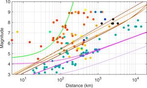
This work considers the effectiveness of earthquakes (EQs) radio precursors mainly in the Extremely Low Frequency (ELF) range and below, and carries out an analysis based on a comprehensive set of EQ events documented in past publications and provided by the Opera 2015 project (six stations located in Italy). A new Radio-Seismic Indicator (RSI) is proposed, with the magnitude-distance relationship physically justified by path-loss expressions of the transverse magnetic mode. Classification performances of past and proposed RSIs are assessed calculating confusion matrices and on those the balanced accuracy and Matthews’ coefficient: the RSI performs significantly better reducing fall-outs and increasing precision for both classes, positive and negative precursors. Performance improvement is inherently limited by the overlap of the classes.
期刊介绍:
The Egyptian Journal of Remote Sensing and Space Sciences (EJRS) encompasses a comprehensive range of topics within Remote Sensing, Geographic Information Systems (GIS), planetary geology, and space technology development, including theories, applications, and modeling. EJRS aims to disseminate high-quality, peer-reviewed research focusing on the advancement of remote sensing and GIS technologies and their practical applications for effective planning, sustainable development, and environmental resource conservation. The journal particularly welcomes innovative papers with broad scientific appeal.


 分享
分享

 求助内容:
求助内容: 应助结果提醒方式:
 扫码关注我们
