Application of Geographic Information System and Google Earth Engine for Spatial Analysis of Land Use by the Legacy Dumpsite at Raipur, Chhattisgarh: A Time Series Analysis.
{"title":"Application of Geographic Information System and Google Earth Engine for Spatial Analysis of Land Use by the Legacy Dumpsite at Raipur, Chhattisgarh: A Time Series Analysis.","authors":"Hunny Sharma, Manisha Ruikar, Arvind Shukla","doi":"10.4103/ijoem.ijoem_290_23","DOIUrl":null,"url":null,"abstract":"<p><strong>Background: </strong>Legacy dump sites pose health and environmental risks. Challenges such as difficulty in monitoring and the impact of policy changes towards remediation efforts remain enigmatic due to complexities.</p><p><strong>Objectives: </strong>Hence this study aimed to use Geographic Information System (GIS) and Google Earth historical imagery to monitor changes in legacy dump site located at Sarona in Raipur and to assess the impact of waste management strategies being implemented currently.</p><p><strong>Methods: </strong>A series of historical images were retrieved using Google Earth Pro 2022 (at eye level of 707 meters) from 2007 to 2021. A polygon was plotted using Google Earth, and area of plotted polygon was estimated using QGIS by projecting in desired coordinates (i.e., WGS84 and 44Q). Percentage change in land area use was observed. Time series analysis was conducted using Autoregressive Integrated Moving Average (ARIMA) model to forecast land area use.</p><p><strong>Results: </strong>There was a fluctuating trend in land area use by the legacy dump site from 2007 to 2019 with 661.90% increase indicating the need for proper waste management system. Time series analysis of the land area used showed a steep reduction of 36.65% in 2019-20, followed by 78.30% in 2020-21. The Solid Waste Management Rules, 2016 and the functioning of Material Recovery Facility (MRF) in 2020 resulted in a significant reduction in land use at the dump site. As per analysis, 4.84 acres of land was found yet to be remediated to which the Raipur Municipal Corporation is committed to accomplish by December 2024.</p><p><strong>Conclusion: </strong>The application of GIS coupled with Google Earth can be a useful tool to monitor changes in land area of legacy dumpsites. Currently employed waste management strategies resulted in sustainable land use and environment conservation, without which it would have experienced exponential growth, necessitating additional land area in the future.</p>","PeriodicalId":43585,"journal":{"name":"Indian Journal of Occupational and Environmental Medicine","volume":"28 4","pages":"326-330"},"PeriodicalIF":0.8000,"publicationDate":"2024-10-01","publicationTypes":"Journal Article","fieldsOfStudy":null,"isOpenAccess":false,"openAccessPdf":"https://www.ncbi.nlm.nih.gov/pmc/articles/PMC11771295/pdf/","citationCount":"0","resultStr":null,"platform":"Semanticscholar","paperid":null,"PeriodicalName":"Indian Journal of Occupational and Environmental Medicine","FirstCategoryId":"1085","ListUrlMain":"https://doi.org/10.4103/ijoem.ijoem_290_23","RegionNum":0,"RegionCategory":null,"ArticlePicture":[],"TitleCN":null,"AbstractTextCN":null,"PMCID":null,"EPubDate":"2024/12/23 0:00:00","PubModel":"Epub","JCR":"Q4","JCRName":"PUBLIC, ENVIRONMENTAL & OCCUPATIONAL HEALTH","Score":null,"Total":0}
引用次数: 0
Abstract
Background: Legacy dump sites pose health and environmental risks. Challenges such as difficulty in monitoring and the impact of policy changes towards remediation efforts remain enigmatic due to complexities.
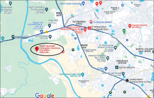
Objectives: Hence this study aimed to use Geographic Information System (GIS) and Google Earth historical imagery to monitor changes in legacy dump site located at Sarona in Raipur and to assess the impact of waste management strategies being implemented currently.
Methods: A series of historical images were retrieved using Google Earth Pro 2022 (at eye level of 707 meters) from 2007 to 2021. A polygon was plotted using Google Earth, and area of plotted polygon was estimated using QGIS by projecting in desired coordinates (i.e., WGS84 and 44Q). Percentage change in land area use was observed. Time series analysis was conducted using Autoregressive Integrated Moving Average (ARIMA) model to forecast land area use.
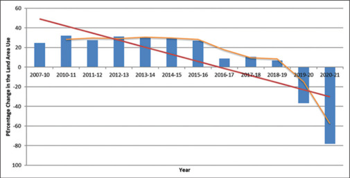
Results: There was a fluctuating trend in land area use by the legacy dump site from 2007 to 2019 with 661.90% increase indicating the need for proper waste management system. Time series analysis of the land area used showed a steep reduction of 36.65% in 2019-20, followed by 78.30% in 2020-21. The Solid Waste Management Rules, 2016 and the functioning of Material Recovery Facility (MRF) in 2020 resulted in a significant reduction in land use at the dump site. As per analysis, 4.84 acres of land was found yet to be remediated to which the Raipur Municipal Corporation is committed to accomplish by December 2024.
Conclusion: The application of GIS coupled with Google Earth can be a useful tool to monitor changes in land area of legacy dumpsites. Currently employed waste management strategies resulted in sustainable land use and environment conservation, without which it would have experienced exponential growth, necessitating additional land area in the future.
期刊介绍:
The website of Indian Journal of Occupational and Environmental Medicine aims to make the printed version of the journal available to the scientific community on the web. The site is purely for educational purpose of the medical community. The site does not cater to the needs of individual patients and is designed to support, not replace, the relationship that exists between a patient/site visitor and his/her existing physician.


 分享
分享
 求助内容:
求助内容: 应助结果提醒方式:
 扫码关注我们
