Qiang Yang , Jingze Dong , Minyao Tan , Jiawei Wang , Dequan Guo , Hao Kang , Ping Wang
{"title":"A novel navigation assistant method for substation inspection robot based on multisensory information fusion","authors":"Qiang Yang , Jingze Dong , Minyao Tan , Jiawei Wang , Dequan Guo , Hao Kang , Ping Wang","doi":"10.1016/j.jare.2025.01.016","DOIUrl":null,"url":null,"abstract":"<div><h3>Introduction</h3><div>Due to the complex environment of the substation, the inspection work of the substation becomes time-consuming and laborious. As a result, the substation inspection robot has gradually become a hot research point.</div></div><div><h3>Objectives</h3><div>At present, the mainstream intelligent inspection robots for substations use high-precision LiDAR sensors for navigation, which has high navigation accuracy but cannot identify the types of obstacles and the road contour boundary, seriously affecting the inspection performance and efficiency. Meanwhile, the high-precision 3D laser radar is too expensive to afford. In order to solve these problems, a novel navigation assistant method is proposed in this paper, which is based on multisensory information fusion.</div></div><div><h3>Methods</h3><div>Asynchronous information matching with multiple sensors was used to match the information collected by different sensors to deal with the time asynchrony. To express the height of obstacles, 2D laser radar was applied to create 3D imaging by being combined with inertial measurement unit (IMU). For perceiving and under-standing the substation environment independently by the inspection robot, ENet was given over to segment color point cloud maps, which was built by introducing optical sensor data. The method was implemented based on the ROS system and transplanted to embedded platform of the inspection robot.</div></div><div><h3>Result</h3><div>Finally, experimental results show that, compared with VLP-32C 3D laser radar sensors, the data volume of navigation assistance module had reduced by 95%. Meanwhile, after training the ENet network, the mean average accuracy value had achieved 86%, which meets the needs of practical engineering applications.</div></div><div><h3>Conclusion</h3><div>In addition, the inspection robot equipped with the navigation assistance module is successfully tested in multiple substations, which shows that the robot can not only identify the road contour and the type of obstacles on the way, but also reduce the amount of data and the cost of hardware.</div></div>","PeriodicalId":14952,"journal":{"name":"Journal of Advanced Research","volume":"77 ","pages":"Pages 407-418"},"PeriodicalIF":13.0000,"publicationDate":"2025-11-01","publicationTypes":"Journal Article","fieldsOfStudy":null,"isOpenAccess":false,"openAccessPdf":"","citationCount":"0","resultStr":null,"platform":"Semanticscholar","paperid":null,"PeriodicalName":"Journal of Advanced Research","FirstCategoryId":"103","ListUrlMain":"https://www.sciencedirect.com/science/article/pii/S2090123225000359","RegionNum":1,"RegionCategory":"综合性期刊","ArticlePicture":[],"TitleCN":null,"AbstractTextCN":null,"PMCID":null,"EPubDate":"2025/2/4 0:00:00","PubModel":"Epub","JCR":"Q1","JCRName":"MULTIDISCIPLINARY SCIENCES","Score":null,"Total":0}
引用次数: 0
Abstract
Introduction
Due to the complex environment of the substation, the inspection work of the substation becomes time-consuming and laborious. As a result, the substation inspection robot has gradually become a hot research point.
Objectives
At present, the mainstream intelligent inspection robots for substations use high-precision LiDAR sensors for navigation, which has high navigation accuracy but cannot identify the types of obstacles and the road contour boundary, seriously affecting the inspection performance and efficiency. Meanwhile, the high-precision 3D laser radar is too expensive to afford. In order to solve these problems, a novel navigation assistant method is proposed in this paper, which is based on multisensory information fusion.
Methods
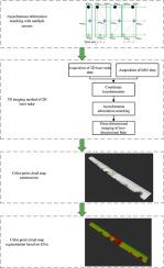
Asynchronous information matching with multiple sensors was used to match the information collected by different sensors to deal with the time asynchrony. To express the height of obstacles, 2D laser radar was applied to create 3D imaging by being combined with inertial measurement unit (IMU). For perceiving and under-standing the substation environment independently by the inspection robot, ENet was given over to segment color point cloud maps, which was built by introducing optical sensor data. The method was implemented based on the ROS system and transplanted to embedded platform of the inspection robot.
Result
Finally, experimental results show that, compared with VLP-32C 3D laser radar sensors, the data volume of navigation assistance module had reduced by 95%. Meanwhile, after training the ENet network, the mean average accuracy value had achieved 86%, which meets the needs of practical engineering applications.
Conclusion
In addition, the inspection robot equipped with the navigation assistance module is successfully tested in multiple substations, which shows that the robot can not only identify the road contour and the type of obstacles on the way, but also reduce the amount of data and the cost of hardware.
期刊介绍:
Journal of Advanced Research (J. Adv. Res.) is an applied/natural sciences, peer-reviewed journal that focuses on interdisciplinary research. The journal aims to contribute to applied research and knowledge worldwide through the publication of original and high-quality research articles in the fields of Medicine, Pharmaceutical Sciences, Dentistry, Physical Therapy, Veterinary Medicine, and Basic and Biological Sciences.
The following abstracting and indexing services cover the Journal of Advanced Research: PubMed/Medline, Essential Science Indicators, Web of Science, Scopus, PubMed Central, PubMed, Science Citation Index Expanded, Directory of Open Access Journals (DOAJ), and INSPEC.


 分享
分享
 求助内容:
求助内容: 应助结果提醒方式:
 扫码关注我们
