Puchen Yan , Yangming Feng , Qisheng Han , Hui Wu , Zongguang Hu , Shaozhong Kang
{"title":"Revolutionizing crop phenotyping: Enhanced UAV LiDAR flight parameter optimization for wide-narrow row cultivation","authors":"Puchen Yan , Yangming Feng , Qisheng Han , Hui Wu , Zongguang Hu , Shaozhong Kang","doi":"10.1016/j.rse.2025.114638","DOIUrl":null,"url":null,"abstract":"<div><div>This study introduces a method for optimizing flight modes using unmanned aerial vehicles (UAVs) and light detection and ranging (LiDAR) technology, aiming for the efficient and accurate estimation of crop phenotypes in wide-narrow row planting patterns, for cotton. It proposes specialized flight plans that take into account the unique growth stages of cotton and recommends the s-along flight path, which is derived from a detailed analysis of the cross flight path, to facilitate effective and precise data collection. A comprehensive phenotypic index, labeled as ‘P', and a fitting function are developed to describe the relationship between flight parameters, paths, and digital elevation model (DEM) data. The study also introduces two flight strategies, one focusing on accuracy and the other on efficiency, utilizing a sophisticated multi-objective optimization method. Comparative analyses show that the s-along flight path significantly improves efficiency without sacrificing accuracy, compared to traditional cross flight path techniques. The use of high-precision prior DEM data greatly enhances the precision in estimating critical phenotypic parameters such as plant height (PH) and leaf area index (LAI), especially during key stages of canopy growth. By carefully adjusting flight height, speed, and overlap during different growth stages, an ideal balance is achieved between the precision and efficiency of data collection. These strategies markedly increase the accuracy of estimating phenotypic features (<em>P</em> > 0.75) and efficiency (by 42 %–44 %). This research highlights the potential of these approaches in facilitating large-scale phenotypic data collection for precision agriculture, demonstrating their ability to simultaneously improve data quality and operational efficiency. Future research will aim to expand the applicability and robustness of these methods across various planting conditions and crops, further enhancing essential tools for the advancement of precision agriculture practices and development.</div></div>","PeriodicalId":417,"journal":{"name":"Remote Sensing of Environment","volume":"320 ","pages":"Article 114638"},"PeriodicalIF":11.4000,"publicationDate":"2025-02-16","publicationTypes":"Journal Article","fieldsOfStudy":null,"isOpenAccess":false,"openAccessPdf":"","citationCount":"0","resultStr":null,"platform":"Semanticscholar","paperid":null,"PeriodicalName":"Remote Sensing of Environment","FirstCategoryId":"5","ListUrlMain":"https://www.sciencedirect.com/science/article/pii/S0034425725000422","RegionNum":1,"RegionCategory":"地球科学","ArticlePicture":[],"TitleCN":null,"AbstractTextCN":null,"PMCID":null,"EPubDate":"","PubModel":"","JCR":"Q1","JCRName":"ENVIRONMENTAL SCIENCES","Score":null,"Total":0}
引用次数: 0
Abstract
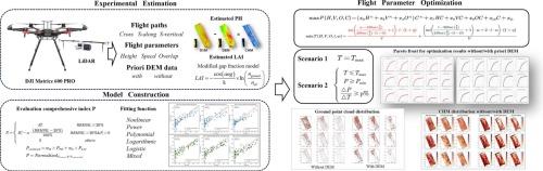
This study introduces a method for optimizing flight modes using unmanned aerial vehicles (UAVs) and light detection and ranging (LiDAR) technology, aiming for the efficient and accurate estimation of crop phenotypes in wide-narrow row planting patterns, for cotton. It proposes specialized flight plans that take into account the unique growth stages of cotton and recommends the s-along flight path, which is derived from a detailed analysis of the cross flight path, to facilitate effective and precise data collection. A comprehensive phenotypic index, labeled as ‘P', and a fitting function are developed to describe the relationship between flight parameters, paths, and digital elevation model (DEM) data. The study also introduces two flight strategies, one focusing on accuracy and the other on efficiency, utilizing a sophisticated multi-objective optimization method. Comparative analyses show that the s-along flight path significantly improves efficiency without sacrificing accuracy, compared to traditional cross flight path techniques. The use of high-precision prior DEM data greatly enhances the precision in estimating critical phenotypic parameters such as plant height (PH) and leaf area index (LAI), especially during key stages of canopy growth. By carefully adjusting flight height, speed, and overlap during different growth stages, an ideal balance is achieved between the precision and efficiency of data collection. These strategies markedly increase the accuracy of estimating phenotypic features (P > 0.75) and efficiency (by 42 %–44 %). This research highlights the potential of these approaches in facilitating large-scale phenotypic data collection for precision agriculture, demonstrating their ability to simultaneously improve data quality and operational efficiency. Future research will aim to expand the applicability and robustness of these methods across various planting conditions and crops, further enhancing essential tools for the advancement of precision agriculture practices and development.
期刊介绍:
Remote Sensing of Environment (RSE) serves the Earth observation community by disseminating results on the theory, science, applications, and technology that contribute to advancing the field of remote sensing. With a thoroughly interdisciplinary approach, RSE encompasses terrestrial, oceanic, and atmospheric sensing.
The journal emphasizes biophysical and quantitative approaches to remote sensing at local to global scales, covering a diverse range of applications and techniques.
RSE serves as a vital platform for the exchange of knowledge and advancements in the dynamic field of remote sensing.


 分享
分享
 求助内容:
求助内容: 应助结果提醒方式:
 扫码关注我们
