Earthu H. Oh , Ki-Weon Seo , Taehwan Jeon , Jooyoung Eom , Jianli Chen , Clark R. Wilson
{"title":"Sediment accumulation at the Amazon coast observed by satellite gravimetry","authors":"Earthu H. Oh , Ki-Weon Seo , Taehwan Jeon , Jooyoung Eom , Jianli Chen , Clark R. Wilson","doi":"10.1016/j.rse.2025.114688","DOIUrl":null,"url":null,"abstract":"<div><div>Terrestrial sediment transport through large rivers exerts a significant impact on coastal morphology, marine ecosystems, and human livelihoods. Accurately measuring these sediment discharges has long been a challenge. Traditional in-situ methods fall short of providing comprehensive and continuous assessments of sediment dynamics due to spatiotemporal and economic constraints. While remote sensing techniques using satellite imagery have offered valuable insights into sediment transportation and deposition, their scope is primarily restricted to observing suspended sediment loads rather than total loads. Sediment accumulation at river margins will cause gravity increases observable by the Gravity Recovery and Climate Experiment (GRACE) and GRACE Follow-On (GFO) missions. Previous efforts to observe sediment signals lacked proper corrections for various GRACE/GFO issues, including leakage of signals from surrounding land, variations in nearby ocean mass, and noise levels that typically exceed sediment signal magnitudes. In this study, we develop a new approach to obtain a satellite gravity estimate of sediment accumulation along the Amazon coast where the largest amount of sediment deposition is expected. We address limitations in previous studies using three steps: Forward modeling to suppress leakage of signal from land to oceans; adjusting ocean mass change via the sea level equation; and filtering using empirical orthogonal functions. The estimated accumulation rate of sediment on the Amazon continental shelf is approximately 1301 Mtons per year for the period June 2002 to May 2023. This estimate is slightly higher than the results from field-based studies, which fall in the range 550 to 1030 Mtons per year.</div></div>","PeriodicalId":417,"journal":{"name":"Remote Sensing of Environment","volume":"321 ","pages":"Article 114688"},"PeriodicalIF":11.4000,"publicationDate":"2025-05-01","publicationTypes":"Journal Article","fieldsOfStudy":null,"isOpenAccess":false,"openAccessPdf":"","citationCount":"0","resultStr":null,"platform":"Semanticscholar","paperid":null,"PeriodicalName":"Remote Sensing of Environment","FirstCategoryId":"5","ListUrlMain":"https://www.sciencedirect.com/science/article/pii/S0034425725000926","RegionNum":1,"RegionCategory":"地球科学","ArticlePicture":[],"TitleCN":null,"AbstractTextCN":null,"PMCID":null,"EPubDate":"2025/3/5 0:00:00","PubModel":"Epub","JCR":"Q1","JCRName":"ENVIRONMENTAL SCIENCES","Score":null,"Total":0}
引用次数: 0
Abstract
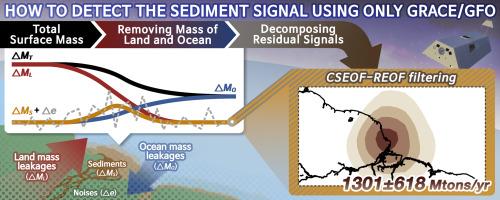
Terrestrial sediment transport through large rivers exerts a significant impact on coastal morphology, marine ecosystems, and human livelihoods. Accurately measuring these sediment discharges has long been a challenge. Traditional in-situ methods fall short of providing comprehensive and continuous assessments of sediment dynamics due to spatiotemporal and economic constraints. While remote sensing techniques using satellite imagery have offered valuable insights into sediment transportation and deposition, their scope is primarily restricted to observing suspended sediment loads rather than total loads. Sediment accumulation at river margins will cause gravity increases observable by the Gravity Recovery and Climate Experiment (GRACE) and GRACE Follow-On (GFO) missions. Previous efforts to observe sediment signals lacked proper corrections for various GRACE/GFO issues, including leakage of signals from surrounding land, variations in nearby ocean mass, and noise levels that typically exceed sediment signal magnitudes. In this study, we develop a new approach to obtain a satellite gravity estimate of sediment accumulation along the Amazon coast where the largest amount of sediment deposition is expected. We address limitations in previous studies using three steps: Forward modeling to suppress leakage of signal from land to oceans; adjusting ocean mass change via the sea level equation; and filtering using empirical orthogonal functions. The estimated accumulation rate of sediment on the Amazon continental shelf is approximately 1301 Mtons per year for the period June 2002 to May 2023. This estimate is slightly higher than the results from field-based studies, which fall in the range 550 to 1030 Mtons per year.
期刊介绍:
Remote Sensing of Environment (RSE) serves the Earth observation community by disseminating results on the theory, science, applications, and technology that contribute to advancing the field of remote sensing. With a thoroughly interdisciplinary approach, RSE encompasses terrestrial, oceanic, and atmospheric sensing.
The journal emphasizes biophysical and quantitative approaches to remote sensing at local to global scales, covering a diverse range of applications and techniques.
RSE serves as a vital platform for the exchange of knowledge and advancements in the dynamic field of remote sensing.


 分享
分享
 求助内容:
求助内容: 应助结果提醒方式:
 扫码关注我们
