{"title":"Investigating the vegetation's temporal–spatial response to meteorological and hydrogeological drought in drylands","authors":"Sedigheh Mohamadi, Ameneh Mianabadi, Sedigheh Anvari","doi":"10.1002/gdj3.203","DOIUrl":null,"url":null,"abstract":"<p>As the most constraining environmental factor of vegetation development in arid areas, soil moisture is mainly supplied by precipitation and groundwater resources. Considering the varying sensitivity of different plant communities to precipitation and groundwater-induced water shortages, the communities' management requires the study of the effects of both meteorological and hydrogeological droughts on vegetation. Therefore, this study sought to model the effects of meteorological and hydrogeological droughts on vegetation indices obtained from MODIS satellite images in the Sirjan plain from 2000 to 2019. To this end, vegetation communities were first identified and separated based on extensive field operations, taking into account the Normalized Difference Vegetation Index (NDVI) and Vegetation Condition Index (VCI) at the plant communities' scale. Then, meteorological drought was calculated using Standardized Precipitation Index (SPI) and the hydrogeological drought was also measured by Groundwater Resource Index (GRI) via the Kriging technique. Finally, the relationship was modelled using Multivariate Linear Regression (MLR). The results revealed that SPI at a 6-month time scale (as an important index) played a significant role in elaborating the changes in VCI in eight communities out of 18 ones at the 6-month scale, acting as a strong and reliable estimator. Moreover, 61.6% of VCI changes in <i>Artemisia sieberi-Seidlitzia rosmarinus</i> community were explained with GRI and SPI at a 6-month time scale, indicating the dependence on groundwater and precipitation. Nonetheless, some communities (i.e. six cases) were unresponsive. These findings draw our attention to the importance of considering the special reaction of each plant community in the management.</p>","PeriodicalId":54351,"journal":{"name":"Geoscience Data Journal","volume":"11 2","pages":"197-215"},"PeriodicalIF":2.4000,"publicationDate":"2023-06-07","publicationTypes":"Journal Article","fieldsOfStudy":null,"isOpenAccess":false,"openAccessPdf":"https://onlinelibrary.wiley.com/doi/epdf/10.1002/gdj3.203","citationCount":"0","resultStr":null,"platform":"Semanticscholar","paperid":null,"PeriodicalName":"Geoscience Data Journal","FirstCategoryId":"89","ListUrlMain":"https://rmets.onlinelibrary.wiley.com/doi/10.1002/gdj3.203","RegionNum":3,"RegionCategory":"地球科学","ArticlePicture":[],"TitleCN":null,"AbstractTextCN":null,"PMCID":null,"EPubDate":"","PubModel":"","JCR":"Q2","JCRName":"GEOSCIENCES, MULTIDISCIPLINARY","Score":null,"Total":0}
引用次数: 0
Abstract
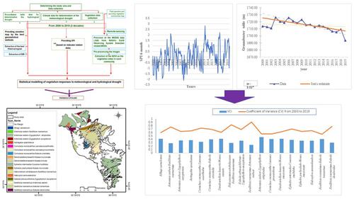
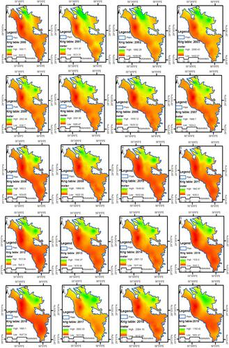
As the most constraining environmental factor of vegetation development in arid areas, soil moisture is mainly supplied by precipitation and groundwater resources. Considering the varying sensitivity of different plant communities to precipitation and groundwater-induced water shortages, the communities' management requires the study of the effects of both meteorological and hydrogeological droughts on vegetation. Therefore, this study sought to model the effects of meteorological and hydrogeological droughts on vegetation indices obtained from MODIS satellite images in the Sirjan plain from 2000 to 2019. To this end, vegetation communities were first identified and separated based on extensive field operations, taking into account the Normalized Difference Vegetation Index (NDVI) and Vegetation Condition Index (VCI) at the plant communities' scale. Then, meteorological drought was calculated using Standardized Precipitation Index (SPI) and the hydrogeological drought was also measured by Groundwater Resource Index (GRI) via the Kriging technique. Finally, the relationship was modelled using Multivariate Linear Regression (MLR). The results revealed that SPI at a 6-month time scale (as an important index) played a significant role in elaborating the changes in VCI in eight communities out of 18 ones at the 6-month scale, acting as a strong and reliable estimator. Moreover, 61.6% of VCI changes in Artemisia sieberi-Seidlitzia rosmarinus community were explained with GRI and SPI at a 6-month time scale, indicating the dependence on groundwater and precipitation. Nonetheless, some communities (i.e. six cases) were unresponsive. These findings draw our attention to the importance of considering the special reaction of each plant community in the management.
Geoscience Data JournalGEOSCIENCES, MULTIDISCIPLINARYMETEOROLOGY-METEOROLOGY & ATMOSPHERIC SCIENCES
CiteScore
5.90
自引率
9.40%
发文量
35
审稿时长
4 weeks
期刊介绍:
Geoscience Data Journal provides an Open Access platform where scientific data can be formally published, in a way that includes scientific peer-review. Thus the dataset creator attains full credit for their efforts, while also improving the scientific record, providing version control for the community and allowing major datasets to be fully described, cited and discovered.
An online-only journal, GDJ publishes short data papers cross-linked to – and citing – datasets that have been deposited in approved data centres and awarded DOIs. The journal will also accept articles on data services, and articles which support and inform data publishing best practices.
Data is at the heart of science and scientific endeavour. The curation of data and the science associated with it is as important as ever in our understanding of the changing earth system and thereby enabling us to make future predictions. Geoscience Data Journal is working with recognised Data Centres across the globe to develop the future strategy for data publication, the recognition of the value of data and the communication and exploitation of data to the wider science and stakeholder communities.


 分享
分享
 求助内容:
求助内容: 应助结果提醒方式:
 扫码关注我们
