Iria Sala, Rui M. A. Caldeira, Sheila N. Estrada-Allis, Elsa Froufe, Xavier Couvelard
{"title":"Lagrangian transport pathways in the northeast Atlantic and their environmental impact","authors":"Iria Sala, Rui M. A. Caldeira, Sheila N. Estrada-Allis, Elsa Froufe, Xavier Couvelard","doi":"10.1215/21573689-2152611","DOIUrl":null,"url":null,"abstract":"<div>\n <p>This study focused on mapping the general transport pathways of the northeast Atlantic Ocean by using the Regional Oceanic Modeling System to calculate ocean current velocity components (<i>u</i>, <i>v</i>, <i>w</i>), and Ariane (an off-line Fortran code dedicated to the computation of three-dimensional streamlines from velocity fields) to calculate the transport of particles around the numerical model domain. The study was undertaken using a 10-year climatic simulation. Statistical comparisons with satellite and in situ data showed that the ocean circulation model captured known regional oceanographic features. Four depth ranges showed different Lagrangian transport pathways, 0–10 m, 20–200 m, 300–500 m, and 600–2000 m, confirming that these routes are consistent with the known ocean circulation patterns. Our results were supported by multiple sources: (i) connectivity between the African coast and the Canary Islands for sardine (<i>Sardina pilchardus</i>), anchovy (<i>Engraulis encrasicolus</i>), (ii) panmixia of lobsters (<i>Scyllarides latus</i> and <i>Palinurus elephas</i>), and European conger eel (<i>Conger conger</i>); (iii) connectivity between Azores and Canary archipelagos for sponge (<i>Phorbas fictitius</i>); and (iv) observed drifting of crude oil from the <i>Prestige</i> oil tanker spill. These results should help guide future observational campaigns, as well as the interpretation of open-ocean transport patterns and the distribution of marine organisms and chemical tracers in the northeast Atlantic region.</p>\n </div>","PeriodicalId":100878,"journal":{"name":"Limnology and Oceanography: Fluids and Environments","volume":"3 1","pages":"40-60"},"PeriodicalIF":0.0000,"publicationDate":"2013-05-24","publicationTypes":"Journal Article","fieldsOfStudy":null,"isOpenAccess":false,"openAccessPdf":"https://sci-hub-pdf.com/10.1215/21573689-2152611","citationCount":"54","resultStr":null,"platform":"Semanticscholar","paperid":null,"PeriodicalName":"Limnology and Oceanography: Fluids and Environments","FirstCategoryId":"1085","ListUrlMain":"https://onlinelibrary.wiley.com/doi/10.1215/21573689-2152611","RegionNum":0,"RegionCategory":null,"ArticlePicture":[],"TitleCN":null,"AbstractTextCN":null,"PMCID":null,"EPubDate":"","PubModel":"","JCR":"","JCRName":"","Score":null,"Total":0}
引用次数: 54
Abstract
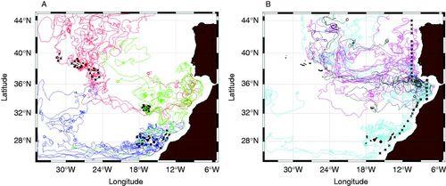
This study focused on mapping the general transport pathways of the northeast Atlantic Ocean by using the Regional Oceanic Modeling System to calculate ocean current velocity components (u, v, w), and Ariane (an off-line Fortran code dedicated to the computation of three-dimensional streamlines from velocity fields) to calculate the transport of particles around the numerical model domain. The study was undertaken using a 10-year climatic simulation. Statistical comparisons with satellite and in situ data showed that the ocean circulation model captured known regional oceanographic features. Four depth ranges showed different Lagrangian transport pathways, 0–10 m, 20–200 m, 300–500 m, and 600–2000 m, confirming that these routes are consistent with the known ocean circulation patterns. Our results were supported by multiple sources: (i) connectivity between the African coast and the Canary Islands for sardine (Sardina pilchardus), anchovy (Engraulis encrasicolus), (ii) panmixia of lobsters (Scyllarides latus and Palinurus elephas), and European conger eel (Conger conger); (iii) connectivity between Azores and Canary archipelagos for sponge (Phorbas fictitius); and (iv) observed drifting of crude oil from the Prestige oil tanker spill. These results should help guide future observational campaigns, as well as the interpretation of open-ocean transport patterns and the distribution of marine organisms and chemical tracers in the northeast Atlantic region.


 分享
分享

 求助内容:
求助内容: 应助结果提醒方式:
 扫码关注我们
