{"title":"Optimizing the maximum reported cluster size for the multinomial-based spatial scan statistic.","authors":"Jisu Moon, Minseok Kim, Inkyung Jung","doi":"10.1186/s12942-023-00353-4","DOIUrl":null,"url":null,"abstract":"<p><strong>Background: </strong>Correctly identifying spatial disease cluster is a fundamental concern in public health and epidemiology. The spatial scan statistic is widely used for detecting spatial disease clusters in spatial epidemiology and disease surveillance. Many studies default to a maximum reported cluster size (MRCS) set at 50% of the total population when searching for spatial clusters. However, this default setting can sometimes report clusters larger than true clusters, which include less relevant regions. For the Poisson, Bernoulli, ordinal, normal, and exponential models, a Gini coefficient has been developed to optimize the MRCS. Yet, no measure is available for the multinomial model.</p><p><strong>Results: </strong>We propose two versions of a spatial cluster information criterion (SCIC) for selecting the optimal MRCS value for the multinomial-based spatial scan statistic. Our simulation study suggests that SCIC improves the accuracy of reporting true clusters. Analysis of the Korea Community Health Survey (KCHS) data further demonstrates that our method identifies more meaningful small clusters compared to the default setting.</p><p><strong>Conclusions: </strong>Our method focuses on improving the performance of the spatial scan statistic by optimizing the MRCS value when using the multinomial model. In public health and disease surveillance, the proposed method can be used to provide more accurate and meaningful spatial cluster detection for multinomial data, such as disease subtypes.</p>","PeriodicalId":48739,"journal":{"name":"International Journal of Health Geographics","volume":"22 1","pages":"30"},"PeriodicalIF":3.0000,"publicationDate":"2023-11-08","publicationTypes":"Journal Article","fieldsOfStudy":null,"isOpenAccess":false,"openAccessPdf":"https://www.ncbi.nlm.nih.gov/pmc/articles/PMC10631089/pdf/","citationCount":"0","resultStr":null,"platform":"Semanticscholar","paperid":null,"PeriodicalName":"International Journal of Health Geographics","FirstCategoryId":"3","ListUrlMain":"https://doi.org/10.1186/s12942-023-00353-4","RegionNum":2,"RegionCategory":"医学","ArticlePicture":[],"TitleCN":null,"AbstractTextCN":null,"PMCID":null,"EPubDate":"","PubModel":"","JCR":"Q2","JCRName":"PUBLIC, ENVIRONMENTAL & OCCUPATIONAL HEALTH","Score":null,"Total":0}
引用次数: 0
Abstract
Background: Correctly identifying spatial disease cluster is a fundamental concern in public health and epidemiology. The spatial scan statistic is widely used for detecting spatial disease clusters in spatial epidemiology and disease surveillance. Many studies default to a maximum reported cluster size (MRCS) set at 50% of the total population when searching for spatial clusters. However, this default setting can sometimes report clusters larger than true clusters, which include less relevant regions. For the Poisson, Bernoulli, ordinal, normal, and exponential models, a Gini coefficient has been developed to optimize the MRCS. Yet, no measure is available for the multinomial model.
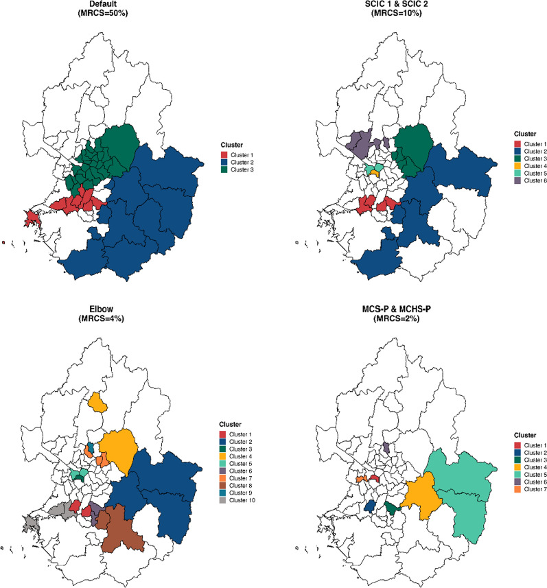
Results: We propose two versions of a spatial cluster information criterion (SCIC) for selecting the optimal MRCS value for the multinomial-based spatial scan statistic. Our simulation study suggests that SCIC improves the accuracy of reporting true clusters. Analysis of the Korea Community Health Survey (KCHS) data further demonstrates that our method identifies more meaningful small clusters compared to the default setting.
Conclusions: Our method focuses on improving the performance of the spatial scan statistic by optimizing the MRCS value when using the multinomial model. In public health and disease surveillance, the proposed method can be used to provide more accurate and meaningful spatial cluster detection for multinomial data, such as disease subtypes.
期刊介绍:
A leader among the field, International Journal of Health Geographics is an interdisciplinary, open access journal publishing internationally significant studies of geospatial information systems and science applications in health and healthcare. With an exceptional author satisfaction rate and a quick time to first decision, the journal caters to readers across an array of healthcare disciplines globally.
International Journal of Health Geographics welcomes novel studies in the health and healthcare context spanning from spatial data infrastructure and Web geospatial interoperability research, to research into real-time Geographic Information Systems (GIS)-enabled surveillance services, remote sensing applications, spatial epidemiology, spatio-temporal statistics, internet GIS and cyberspace mapping, participatory GIS and citizen sensing, geospatial big data, healthy smart cities and regions, and geospatial Internet of Things and blockchain.


 分享
分享
 求助内容:
求助内容: 应助结果提醒方式:
 扫码关注我们
