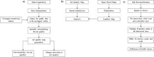
COVID-19 had such a devastating effect on humanity that several governments worldwide were forced to establish regional and national level Lockdowns in an attempt to reduce the severity of the infection. The nationwide lockdown had been implemented on 24 March 2020 in India with the inevitable restrictions. Along with the effect on the population of more than 1.3 billion people, unprecedented variations in air pollution levels across the country have been witnessed. This Geographic Information System (GIS) approach aims to provide a detailed analysis of spatiotemporal variations in pollution levels prior to, during, and after the Lockdown at multiple locations in Delhi using pollution data from ground monitoring stations under the supervision of the Central Pollution Control Board (CPCB). The monthly contributions of toxic pollutants were determined using several statistical methods, among which the exponential averaging method demonstrated the most favorable outcomes. The interpolation techniques were used to estimate the spatial pollution extent. The study reveals that the residential areas and the commercial complexes had a significant reduction in the pollutant levels in the presence of the lockdown and again a sudden increase in pollution after the relaxation of the curbs. Furthermore, a site suitability analysis was utilized to tackle the growing pollutants level by choosing specific points wherein air quality purifiers can be installed.


 分享
分享
 求助内容:
求助内容: 应助结果提醒方式:
 扫码关注我们
