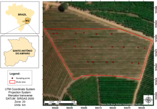
Soil compaction is considered one of the main threats to structural soil degradation, and it promotes increased densification of soil particles, impairs ecosystem services, the plant development, and therefore affects agricultural profitability. In this sense, this study aimed to analyze the feasibility of using a Remotely Piloted Aircraft System (RPAS) by relating parameters derived from aerial images based on Vegetation Indices (VIs) and the Canopy Height Model (CHM) with soil compaction in a coffee plantation area. The study was conducted in a commercial coffee plantation with the cultivar Mundo Novo with 14 years of implantation. Two aerial surveys were carried out, the first to determine the CHM and define the sampling points and the second for radiometric calculations of VIs. In the sampling point were collected data plant height, soil characterization, soil penetration resistance and productivity. Images were processed by Pix4D software, and the data analysis at QGIS and RStudio. As at results, no statistically significant differences were detected between the different plant height zones in the soil chemical analysis; significant statistical differences between plant height zones were detected for penetration resistance, which is correlated to productivity data; and the radiometric data presented a correlation with the penetration resistance data, making it possible to determine VIs (NDRE and MTCI) with correlation to the compaction data allowing the estimation of such variable. In this way, the possibility of monitoring the height variations of the coffee crop using RPAS to demarcate compacted zones was evidenced.


