Drone remote sensing of wheat N using hyperspectral sensor and machine learning

IF 5.4 2区 农林科学 Q1 AGRICULTURE, MULTIDISCIPLINARY Precision Agriculture Pub Date : 2023-11-08 DOI:10.1007/s11119-023-10089-7
Rabi N. Sahoo, R. G. Rejith, Shalini Gakhar, Rajeev Ranjan, Mahesh C. Meena, Abir Dey, Joydeep Mukherjee, Rajkumar Dhakar, Abhishek Meena, Anchal Daas, Subhash Babu, Pravin K. Upadhyay, Kapila Sekhawat, Sudhir Kumar, Mahesh Kumar, Viswanathan Chinnusamy, Manoj Khanna
{"title":"Drone remote sensing of wheat N using hyperspectral sensor and machine learning","authors":"Rabi N. Sahoo, R. G. Rejith, Shalini Gakhar, Rajeev Ranjan, Mahesh C. Meena, Abir Dey, Joydeep Mukherjee, Rajkumar Dhakar, Abhishek Meena, Anchal Daas, Subhash Babu, Pravin K. Upadhyay, Kapila Sekhawat, Sudhir Kumar, Mahesh Kumar, Viswanathan Chinnusamy, Manoj Khanna","doi":"10.1007/s11119-023-10089-7","DOIUrl":null,"url":null,"abstract":"<p>Plant nitrogen (N) is one of the key factors for its growth and yield. Timely assessment of plant N at a spatio-temporal scale enables its precision management in the field scale with better N use efficiency. Airborne imaging spectroscopy is a potential technique for non-invasive near real-time rapid assessment of plant N on a field scale. The present study attempted to assess plant N in a wheat field with three different irrigation levels (I<sub>1</sub>–I<sub>3</sub>) along with five nitrogen treatments (N<sub>0</sub>–N<sub>4</sub>) using a UAV hyperspectral imager with a spectral range of 400 to 1000 nm. A total of 61 vegetative indices were evaluated to find suitable indices for estimating plant N. A hybrid method of R-Square (R<sup>2</sup>) and Variable Importance Projection (VIP) followed by Variance Inflation Factor was used to limit the best suitable N-sensitive 13 spectral indices. The selected indices were used as feature vectors in the Artificial Neural Network algorithm to model and generate a spatial map of plant N in the experimental wheat field. The model resulted in R<sup>2</sup> values of 0.97, 0.84, and 0.86 for training, validation, and testing respectively for plant N assessment.</p>","PeriodicalId":20423,"journal":{"name":"Precision Agriculture","volume":"55 5","pages":""},"PeriodicalIF":5.4000,"publicationDate":"2023-11-08","publicationTypes":"Journal Article","fieldsOfStudy":null,"isOpenAccess":false,"openAccessPdf":"","citationCount":"0","resultStr":null,"platform":"Semanticscholar","paperid":null,"PeriodicalName":"Precision Agriculture","FirstCategoryId":"97","ListUrlMain":"https://doi.org/10.1007/s11119-023-10089-7","RegionNum":2,"RegionCategory":"农林科学","ArticlePicture":[],"TitleCN":null,"AbstractTextCN":null,"PMCID":null,"EPubDate":"","PubModel":"","JCR":"Q1","JCRName":"AGRICULTURE, MULTIDISCIPLINARY","Score":null,"Total":0}
引用次数: 0

Abstract

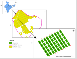
Plant nitrogen (N) is one of the key factors for its growth and yield. Timely assessment of plant N at a spatio-temporal scale enables its precision management in the field scale with better N use efficiency. Airborne imaging spectroscopy is a potential technique for non-invasive near real-time rapid assessment of plant N on a field scale. The present study attempted to assess plant N in a wheat field with three different irrigation levels (I1–I3) along with five nitrogen treatments (N0–N4) using a UAV hyperspectral imager with a spectral range of 400 to 1000 nm. A total of 61 vegetative indices were evaluated to find suitable indices for estimating plant N. A hybrid method of R-Square (R2) and Variable Importance Projection (VIP) followed by Variance Inflation Factor was used to limit the best suitable N-sensitive 13 spectral indices. The selected indices were used as feature vectors in the Artificial Neural Network algorithm to model and generate a spatial map of plant N in the experimental wheat field. The model resulted in R2 values of 0.97, 0.84, and 0.86 for training, validation, and testing respectively for plant N assessment.

Abstract Image

查看原文
分享 分享
微信好友 朋友圈 QQ好友 复制链接
本刊更多论文
基于高光谱传感器和机器学习的无人机小麦氮遥感研究
植物氮素是影响其生长和产量的关键因素之一。在时空尺度上对植物氮素进行及时评估,可以在田间尺度上进行精准管理,提高氮素利用效率。航空成像光谱技术是一种有潜力的无创近实时快速评估植物氮素的技术。本研究试图利用光谱范围为400 ~ 1000 nm的无人机高光谱成像仪,评估小麦在三种不同灌溉水平(i1 ~ i3)和五种氮肥处理(n0 ~ n4)下的植株氮。利用r - squared (R2)和Variable Importance Projection (VIP)结合方差膨胀因子(Variance Inflation Factor)的杂交方法筛选了13个最适合的n敏感光谱指标。将选取的指标作为特征向量,在人工神经网络算法中建模并生成试验麦田植株N的空间图。模型对植物氮素的训练、验证和测试的R2分别为0.97、0.84和0.86。
本文章由计算机程序翻译,如有差异,请以英文原文为准。
求助全文
约1分钟内获得全文 去求助
来源期刊
Precision Agriculture
Precision Agriculture 农林科学-农业综合
CiteScore
12.30
自引率
8.10%
发文量
103
审稿时长
>24 weeks
期刊介绍: Precision Agriculture promotes the most innovative results coming from the research in the field of precision agriculture. It provides an effective forum for disseminating original and fundamental research and experience in the rapidly advancing area of precision farming. There are many topics in the field of precision agriculture; therefore, the topics that are addressed include, but are not limited to: Natural Resources Variability: Soil and landscape variability, digital elevation models, soil mapping, geostatistics, geographic information systems, microclimate, weather forecasting, remote sensing, management units, scale, etc. Managing Variability: Sampling techniques, site-specific nutrient and crop protection chemical recommendation, crop quality, tillage, seed density, seed variety, yield mapping, remote sensing, record keeping systems, data interpretation and use, crops (corn, wheat, sugar beets, potatoes, peanut, cotton, vegetables, etc.), management scale, etc. Engineering Technology: Computers, positioning systems, DGPS, machinery, tillage, planting, nutrient and crop protection implements, manure, irrigation, fertigation, yield monitor and mapping, soil physical and chemical characteristic sensors, weed/pest mapping, etc. Profitability: MEY, net returns, BMPs, optimum recommendations, crop quality, technology cost, sustainability, social impacts, marketing, cooperatives, farm scale, crop type, etc. Environment: Nutrient, crop protection chemicals, sediments, leaching, runoff, practices, field, watershed, on/off farm, artificial drainage, ground water, surface water, etc. Technology Transfer: Skill needs, education, training, outreach, methods, surveys, agri-business, producers, distance education, Internet, simulations models, decision support systems, expert systems, on-farm experimentation, partnerships, quality of rural life, etc.
期刊最新文献
Usability of smartphone-based RGB vegetation indices for steppe rangeland inventory and monitoring Devising optimized maize nitrogen stress indices in complex field conditions from UAV hyperspectral imagery Spatial and temporal correlation between soil and rice relative yield in small-scale paddy fields and management zones Accuracy and robustness of a plant-level cabbage yield prediction system generated by assimilating UAV-based remote sensing data into a crop simulation model Correction to: On-farm experimentation of precision agriculture for differential seed and fertilizer management in semi-arid rainfed zones
×
引用
GB/T 7714-2015
复制
MLA
复制
APA
复制
导出至
BibTeX EndNote RefMan NoteFirst NoteExpress
×
×
提示
您的信息不完整,为了账户安全,请先补充。
现在去补充
×
提示
您因"违规操作"
具体请查看互助需知
我知道了
×
提示
现在去查看 取消
×
提示
确定
0
微信
客服QQ
Book学术公众号 扫码关注我们
反馈
×
意见反馈
请填写您的意见或建议
请填写您的手机或邮箱
已复制链接
已复制链接
快去分享给好友吧!
我知道了
×
扫码分享
扫码分享
Book学术官方微信
Book学术文献互助
Book学术文献互助群
群 号:481959085
Book学术
文献互助 智能选刊 最新文献 互助须知 联系我们:info@booksci.cn
Book学术提供免费学术资源搜索服务,方便国内外学者检索中英文文献。致力于提供最便捷和优质的服务体验。
Copyright © 2023 Book学术 All rights reserved.
ghs 京公网安备 11010802042870号 京ICP备2023020795号-1