Guo Jialeng, Santiago Suárez de la Fuente, Tristan Smith
{"title":"BoatNet: automated small boat composition detection using deep learning on satellite imagery.","authors":"Guo Jialeng, Santiago Suárez de la Fuente, Tristan Smith","doi":"10.14324/111.444/ucloe.000058","DOIUrl":null,"url":null,"abstract":"<p><p>Tracking and measuring national carbon footprints is key to achieving the ambitious goals set by the Paris Agreement on carbon emissions. According to statistics, more than 10% of global transportation carbon emissions result from shipping. However, accurate tracking of the emissions of the small boat segment is not well established. Past research looked into the role played by small boat fleets in terms of greenhouse gases, but this has relied either on high-level technological and operational assumptions or the installation of global navigation satellite system sensors to understand how this vessel class behaves. This research is undertaken mainly in relation to fishing and recreational boats. With the advent of open-access satellite imagery and its ever-increasing resolution, it can support innovative methodologies that could eventually lead to the quantification of greenhouse gas emissions. Our work used deep learning algorithms to detect small boats in three cities in the Gulf of California in Mexico. The work produced a methodology named BoatNet that can detect, measure and classify small boats with leisure boats and fishing boats even under low-resolution and blurry satellite images, achieving an accuracy of 93.9% with a precision of 74.0%. Future work should focus on attributing a boat activity to fuel consumption and operational profile to estimate small boat greenhouse gas emissions in any given region.</p>","PeriodicalId":75271,"journal":{"name":"UCL open environment","volume":"5 ","pages":"e058"},"PeriodicalIF":0.0000,"publicationDate":"2023-01-01","publicationTypes":"Journal Article","fieldsOfStudy":null,"isOpenAccess":false,"openAccessPdf":"https://www.ncbi.nlm.nih.gov/pmc/articles/PMC10208328/pdf/","citationCount":"0","resultStr":null,"platform":"Semanticscholar","paperid":null,"PeriodicalName":"UCL open environment","FirstCategoryId":"1085","ListUrlMain":"https://doi.org/10.14324/111.444/ucloe.000058","RegionNum":0,"RegionCategory":null,"ArticlePicture":[],"TitleCN":null,"AbstractTextCN":null,"PMCID":null,"EPubDate":"","PubModel":"","JCR":"","JCRName":"","Score":null,"Total":0}
引用次数: 0
Abstract
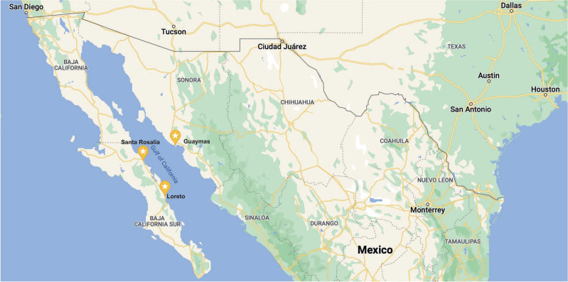
Tracking and measuring national carbon footprints is key to achieving the ambitious goals set by the Paris Agreement on carbon emissions. According to statistics, more than 10% of global transportation carbon emissions result from shipping. However, accurate tracking of the emissions of the small boat segment is not well established. Past research looked into the role played by small boat fleets in terms of greenhouse gases, but this has relied either on high-level technological and operational assumptions or the installation of global navigation satellite system sensors to understand how this vessel class behaves. This research is undertaken mainly in relation to fishing and recreational boats. With the advent of open-access satellite imagery and its ever-increasing resolution, it can support innovative methodologies that could eventually lead to the quantification of greenhouse gas emissions. Our work used deep learning algorithms to detect small boats in three cities in the Gulf of California in Mexico. The work produced a methodology named BoatNet that can detect, measure and classify small boats with leisure boats and fishing boats even under low-resolution and blurry satellite images, achieving an accuracy of 93.9% with a precision of 74.0%. Future work should focus on attributing a boat activity to fuel consumption and operational profile to estimate small boat greenhouse gas emissions in any given region.


 分享
分享

 求助内容:
求助内容: 应助结果提醒方式:
 扫码关注我们
