Iván Gutiérrez-Avila, Kodi B. Arfer, Sandy Wong, Johnathan Rush, Itai Kloog, Allan C. Just
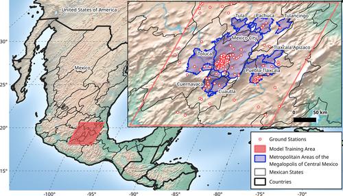
{"title":"A spatiotemporal reconstruction of daily ambient temperature using satellite data in the Megalopolis of Central Mexico from 2003 to 2019","authors":"Iván Gutiérrez-Avila, Kodi B. Arfer, Sandy Wong, Johnathan Rush, Itai Kloog, Allan C. Just","doi":"10.1002/joc.7060","DOIUrl":null,"url":null,"abstract":"<p>While weather stations generally capture near-surface ambient air temperature (Ta) at a high temporal resolution to calculate daily values (i.e., daily minimum, mean, and maximum Ta), their fixed locations can limit their spatial coverage and resolution even in densely populated urban areas. As a result, data from weather stations alone may be inadequate for Ta-related epidemiology particularly when the stations are not located in the areas of interest for human exposure assessment. To address this limitation in the Megalopolis of Central Mexico (MCM), we developed the first spatiotemporally resolved hybrid satellite-based land use regression Ta model for the region, home to nearly 30 million people and includes Mexico City and seven more metropolitan areas. Our model predicted daily minimum, mean, and maximum Ta for the years 2003–2019. We used data from 120 weather stations and Land Surface Temperature (LST) data from NASA's MODIS instruments on the Aqua and Terra satellites on a 1 × 1 km grid. We generated a satellite-hybrid mixed-effects model for each year, regressing Ta measurements against land use terms, day-specific random intercepts, and fixed and random LST slopes. We assessed model performance using 10-fold cross-validation at withheld stations. Across all years, the root-mean-square error ranged from 0.92 to 1.92 K and the <i>R</i><sup>2</sup> ranged from .78 to .95. To demonstrate the utility of our model for health research, we evaluated the total number of days in the year 2010 when residents ≥65 years old were exposed to Ta extremes (above 30°C or below 5°C). Our model provides much needed high-quality Ta estimates for epidemiology studies in the MCM region.</p>","PeriodicalId":13779,"journal":{"name":"International Journal of Climatology","volume":"41 8","pages":"4095-4111"},"PeriodicalIF":2.8000,"publicationDate":"2021-02-17","publicationTypes":"Journal Article","fieldsOfStudy":null,"isOpenAccess":false,"openAccessPdf":"https://sci-hub-pdf.com/10.1002/joc.7060","citationCount":"12","resultStr":null,"platform":"Semanticscholar","paperid":null,"PeriodicalName":"International Journal of Climatology","FirstCategoryId":"89","ListUrlMain":"https://onlinelibrary.wiley.com/doi/10.1002/joc.7060","RegionNum":3,"RegionCategory":"地球科学","ArticlePicture":[],"TitleCN":null,"AbstractTextCN":null,"PMCID":null,"EPubDate":"","PubModel":"","JCR":"Q2","JCRName":"METEOROLOGY & ATMOSPHERIC SCIENCES","Score":null,"Total":0}
引用次数: 12
Abstract
While weather stations generally capture near-surface ambient air temperature (Ta) at a high temporal resolution to calculate daily values (i.e., daily minimum, mean, and maximum Ta), their fixed locations can limit their spatial coverage and resolution even in densely populated urban areas. As a result, data from weather stations alone may be inadequate for Ta-related epidemiology particularly when the stations are not located in the areas of interest for human exposure assessment. To address this limitation in the Megalopolis of Central Mexico (MCM), we developed the first spatiotemporally resolved hybrid satellite-based land use regression Ta model for the region, home to nearly 30 million people and includes Mexico City and seven more metropolitan areas. Our model predicted daily minimum, mean, and maximum Ta for the years 2003–2019. We used data from 120 weather stations and Land Surface Temperature (LST) data from NASA's MODIS instruments on the Aqua and Terra satellites on a 1 × 1 km grid. We generated a satellite-hybrid mixed-effects model for each year, regressing Ta measurements against land use terms, day-specific random intercepts, and fixed and random LST slopes. We assessed model performance using 10-fold cross-validation at withheld stations. Across all years, the root-mean-square error ranged from 0.92 to 1.92 K and the R2 ranged from .78 to .95. To demonstrate the utility of our model for health research, we evaluated the total number of days in the year 2010 when residents ≥65 years old were exposed to Ta extremes (above 30°C or below 5°C). Our model provides much needed high-quality Ta estimates for epidemiology studies in the MCM region.
期刊介绍:
The International Journal of Climatology aims to span the well established but rapidly growing field of climatology, through the publication of research papers, short communications, major reviews of progress and reviews of new books and reports in the area of climate science. The Journal’s main role is to stimulate and report research in climatology, from the expansive fields of the atmospheric, biophysical, engineering and social sciences. Coverage includes: Climate system science; Local to global scale climate observations and modelling; Seasonal to interannual climate prediction; Climatic variability and climate change; Synoptic, dynamic and urban climatology, hydroclimatology, human bioclimatology, ecoclimatology, dendroclimatology, palaeoclimatology, marine climatology and atmosphere-ocean interactions; Application of climatological knowledge to environmental assessment and management and economic production; Climate and society interactions


 分享
分享
 求助内容:
求助内容: 应助结果提醒方式:
 扫码关注我们
