Jessica Penny , Dibesh Khadka , Priscila B.R. Alves , Albert S. Chen , Slobodan Djordjević
{"title":"利用地理信息系统框架中的多准则决策分析来评估干旱风险","authors":"Jessica Penny , Dibesh Khadka , Priscila B.R. Alves , Albert S. Chen , Slobodan Djordjević","doi":"10.1016/j.wroa.2023.100190","DOIUrl":null,"url":null,"abstract":"<div><p>In this study we use the Mun river basin to demonstrate how a Multi Criteria Decision Analysis – Geographical Information Systems (MCDA-GIS) methodology can be used to assess drought risk. This paper not only provides a step forward in considering other elements such as land use change, climate within drought risk but also splits annual risk across three seasons (wet, cool and hot), previously not done. We also investigate how land use change, in the form of a/reforestation and changing crop varieties could potentially mitigate future risk.</p><p>MCDA rankings from experts found that climatic factors such as rainfall, evapotranspiration and maximum temperature were the most significant. By splitting up the seasons we have been able to observe the temporal and spatial changes in drought risk at an increased detail, an important step in mitigating water security issue in the future. Results for cool months found an increased risk in the north and east (Surin, Si Sa Ket and Rio Et). With hot months finding increased risk in the east (Surin and Si Sa Ket especially) and west in Nakon Ratchasima. Whereas the wet season risk was greatest in the West (Nakon Ratchima, Khon Kean and Mara Sarakham). Differences in future land use scenarios compared to 2017 found that if current trends continued (BAU), the areas at risk from drought will increase. However, by changing land use in the form of a/reforestation (COB) or changing crop types (PRO), drought risk will decrease. Thus, the MCDA-GIS methodology serves as a great starting point, providing a high flexibility in data, meaning the methodology can readily applied to other case studies across the world.</p></div>","PeriodicalId":52198,"journal":{"name":"Water Research X","volume":"20 ","pages":"Article 100190"},"PeriodicalIF":8.2000,"publicationDate":"2023-09-01","publicationTypes":"Journal Article","fieldsOfStudy":null,"isOpenAccess":false,"openAccessPdf":"https://ftp.ncbi.nlm.nih.gov/pub/pmc/oa_pdf/c4/81/main.PMC10477050.pdf","citationCount":"0","resultStr":"{\"title\":\"Using multi criteria decision analysis in a geographical information system framework to assess drought risk\",\"authors\":\"Jessica Penny , Dibesh Khadka , Priscila B.R. Alves , Albert S. Chen , Slobodan Djordjević\",\"doi\":\"10.1016/j.wroa.2023.100190\",\"DOIUrl\":null,\"url\":null,\"abstract\":\"<div><p>In this study we use the Mun river basin to demonstrate how a Multi Criteria Decision Analysis – Geographical Information Systems (MCDA-GIS) methodology can be used to assess drought risk. This paper not only provides a step forward in considering other elements such as land use change, climate within drought risk but also splits annual risk across three seasons (wet, cool and hot), previously not done. We also investigate how land use change, in the form of a/reforestation and changing crop varieties could potentially mitigate future risk.</p><p>MCDA rankings from experts found that climatic factors such as rainfall, evapotranspiration and maximum temperature were the most significant. By splitting up the seasons we have been able to observe the temporal and spatial changes in drought risk at an increased detail, an important step in mitigating water security issue in the future. Results for cool months found an increased risk in the north and east (Surin, Si Sa Ket and Rio Et). With hot months finding increased risk in the east (Surin and Si Sa Ket especially) and west in Nakon Ratchasima. Whereas the wet season risk was greatest in the West (Nakon Ratchima, Khon Kean and Mara Sarakham). Differences in future land use scenarios compared to 2017 found that if current trends continued (BAU), the areas at risk from drought will increase. However, by changing land use in the form of a/reforestation (COB) or changing crop types (PRO), drought risk will decrease. Thus, the MCDA-GIS methodology serves as a great starting point, providing a high flexibility in data, meaning the methodology can readily applied to other case studies across the world.</p></div>\",\"PeriodicalId\":52198,\"journal\":{\"name\":\"Water Research X\",\"volume\":\"20 \",\"pages\":\"Article 100190\"},\"PeriodicalIF\":8.2000,\"publicationDate\":\"2023-09-01\",\"publicationTypes\":\"Journal Article\",\"fieldsOfStudy\":null,\"isOpenAccess\":false,\"openAccessPdf\":\"https://ftp.ncbi.nlm.nih.gov/pub/pmc/oa_pdf/c4/81/main.PMC10477050.pdf\",\"citationCount\":\"0\",\"resultStr\":null,\"platform\":\"Semanticscholar\",\"paperid\":null,\"PeriodicalName\":\"Water Research X\",\"FirstCategoryId\":\"93\",\"ListUrlMain\":\"https://www.sciencedirect.com/science/article/pii/S2589914723000269\",\"RegionNum\":2,\"RegionCategory\":\"环境科学与生态学\",\"ArticlePicture\":[],\"TitleCN\":null,\"AbstractTextCN\":null,\"PMCID\":null,\"EPubDate\":\"2023/6/24 0:00:00\",\"PubModel\":\"Epub\",\"JCR\":\"Q1\",\"JCRName\":\"ENGINEERING, ENVIRONMENTAL\",\"Score\":null,\"Total\":0}","platform":"Semanticscholar","paperid":null,"PeriodicalName":"Water Research X","FirstCategoryId":"93","ListUrlMain":"https://www.sciencedirect.com/science/article/pii/S2589914723000269","RegionNum":2,"RegionCategory":"环境科学与生态学","ArticlePicture":[],"TitleCN":null,"AbstractTextCN":null,"PMCID":null,"EPubDate":"2023/6/24 0:00:00","PubModel":"Epub","JCR":"Q1","JCRName":"ENGINEERING, ENVIRONMENTAL","Score":null,"Total":0}
引用次数: 0
摘要
在这项研究中,我们使用孟河流域来证明如何使用多标准决策分析-地理信息系统(MCDA-GIS)方法来评估干旱风险。这篇论文不仅在考虑土地利用变化、干旱风险中的气候等其他因素方面迈出了一步,而且还将年度风险划分为三个季节(潮湿、凉爽和炎热),这是以前没有做过的。我们还调查了土地利用的变化,以植树造林和改变作物品种的形式,如何潜在地减轻未来的风险。来自专家的MCDA排名发现,降雨量、蒸散量和最高温度等气候因素最为显著。通过划分季节,我们能够更详细地观察干旱风险的时间和空间变化,这是未来缓解水安全问题的重要一步。凉爽月份的结果发现,北部和东部(Surin、Si Sa Ket和Rio Et)的风险增加。随着炎热的月份,东部(尤其是素林和锡萨科特)和西部呵叻的风险增加。而雨季风险在西部最大(Nakon Ratchima、Khon Kean和Mara Sarakham)。与2017年相比,未来土地利用情景的差异发现,如果目前的趋势继续下去(BAU),面临干旱风险的地区将增加。然而,通过以植树造林(COB)或改变作物类型(PRO)的形式改变土地利用,干旱风险将降低。因此,MCDA-GIS方法是一个很好的起点,提供了数据的高度灵活性,这意味着该方法可以很容易地应用于世界各地的其他案例研究。
Using multi criteria decision analysis in a geographical information system framework to assess drought risk
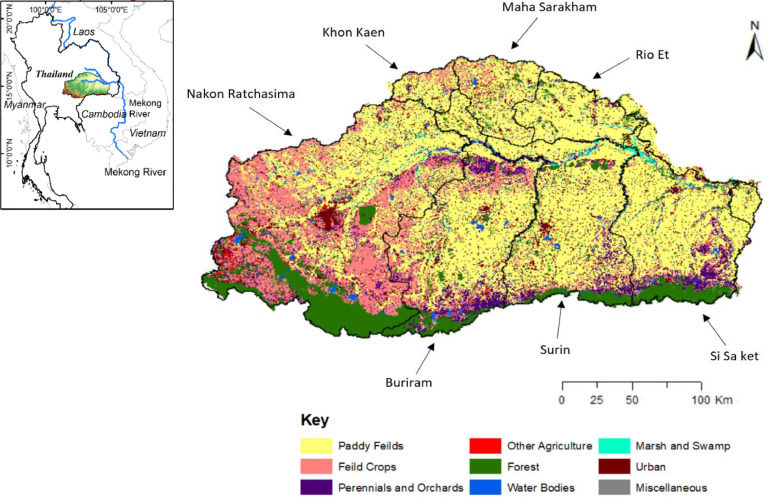
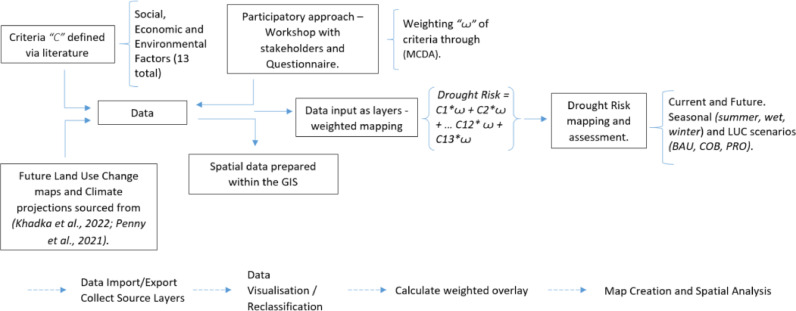
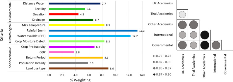
In this study we use the Mun river basin to demonstrate how a Multi Criteria Decision Analysis – Geographical Information Systems (MCDA-GIS) methodology can be used to assess drought risk. This paper not only provides a step forward in considering other elements such as land use change, climate within drought risk but also splits annual risk across three seasons (wet, cool and hot), previously not done. We also investigate how land use change, in the form of a/reforestation and changing crop varieties could potentially mitigate future risk.
MCDA rankings from experts found that climatic factors such as rainfall, evapotranspiration and maximum temperature were the most significant. By splitting up the seasons we have been able to observe the temporal and spatial changes in drought risk at an increased detail, an important step in mitigating water security issue in the future. Results for cool months found an increased risk in the north and east (Surin, Si Sa Ket and Rio Et). With hot months finding increased risk in the east (Surin and Si Sa Ket especially) and west in Nakon Ratchasima. Whereas the wet season risk was greatest in the West (Nakon Ratchima, Khon Kean and Mara Sarakham). Differences in future land use scenarios compared to 2017 found that if current trends continued (BAU), the areas at risk from drought will increase. However, by changing land use in the form of a/reforestation (COB) or changing crop types (PRO), drought risk will decrease. Thus, the MCDA-GIS methodology serves as a great starting point, providing a high flexibility in data, meaning the methodology can readily applied to other case studies across the world.
Water Research XEnvironmental Science-Water Science and Technology
CiteScore
12.30
自引率
1.30%
发文量
19
期刊介绍:
Water Research X is a sister journal of Water Research, which follows a Gold Open Access model. It focuses on publishing concise, letter-style research papers, visionary perspectives and editorials, as well as mini-reviews on emerging topics. The Journal invites contributions from researchers worldwide on various aspects of the science and technology related to the human impact on the water cycle, water quality, and its global management.


 分享
分享
 求助内容:
求助内容: 应助结果提醒方式:
 扫码关注我们
