Jianpo Wang, Gang Li, Jiaobei Wang, Qifan Nie, Yue Yu, Tingting Xu
{"title":"不确定情况下城市生活物资应急保障能力建模与配送服务体系优化——以新冠肺炎疫情期间西安市为例","authors":"Jianpo Wang, Gang Li, Jiaobei Wang, Qifan Nie, Yue Yu, Tingting Xu","doi":"10.1007/s43762-022-00076-5","DOIUrl":null,"url":null,"abstract":"<p><p>The severe acute respiratory syndrome coronavirus 2 (COVID-19) pandemic has brought a heavy burden and severe challenges to the global economy and society, forcing different countries and regions to take various preventive and control measures ranging from normal operations to partial or complete lockdowns. Taking Xi'an city as an example, based on multisource POI data for the government's vegetable storage delivery points, logistics terminal outlets, designated medical institutions, communities, etc., this paper uses the Gaussian two-step floating catchment area method (2SFCA) and other spatial analysis methods to analyze the spatial pattern of emergency support points (ESPs) and express logistics terminals in different situations. It then discusses construction and optimization strategies for urban emergency support and delivery service systems. The conclusions are as follows. (1) The ESPs are supported by large-scale chain supermarkets and fresh supermarkets, which are positively related to the population distribution.The spatial distribution of express logistics terminals is imbalanced, dense in the middle while sparse at the edges. 90% of express terminals are located within a 500 m distance of communities, however, some terminals are shared, which restrict their ability to provide emergency support to surrounding residents. (2) In general, accessibility increases as the number of ESPs increases; under normal traffic, as the distance threshold increases, the available ESPs increase but accessibility slightly decreases; with a traffic lockdown, the travel distance of residents is limited, and as ESPs increase, accessibility and the number of POIs covered significantly increase. (3) The spatial accessibility of the ESPs has a \"dumbbell-shaped\" distribution, with highest accessibility in the north and south, higher around the second ring road, slightly lower in the center, and lowest near the third ring road at east and west. (4) With the goal of \"opening up the logistics artery and unblocking the distribution microcirculation\", based on \"ESPs + couriers + express logistics terminals + residents\", this paper proposes to build and optimize the urban emergency support and delivery service system to improve the comprehensive ability of the city to cope with uncertain risks.</p>","PeriodicalId":72667,"journal":{"name":"Computational urban science","volume":"2 1","pages":"47"},"PeriodicalIF":3.2000,"publicationDate":"2022-01-01","publicationTypes":"Journal Article","fieldsOfStudy":null,"isOpenAccess":false,"openAccessPdf":"https://www.ncbi.nlm.nih.gov/pmc/articles/PMC9789736/pdf/","citationCount":"1","resultStr":"{\"title\":\"Modeling of emergency support capacity and optimization of delivery service system for urban living materials under uncertain situations: a case study of Xi'an City during COVID-19 epidemic.\",\"authors\":\"Jianpo Wang, Gang Li, Jiaobei Wang, Qifan Nie, Yue Yu, Tingting Xu\",\"doi\":\"10.1007/s43762-022-00076-5\",\"DOIUrl\":null,\"url\":null,\"abstract\":\"<p><p>The severe acute respiratory syndrome coronavirus 2 (COVID-19) pandemic has brought a heavy burden and severe challenges to the global economy and society, forcing different countries and regions to take various preventive and control measures ranging from normal operations to partial or complete lockdowns. Taking Xi'an city as an example, based on multisource POI data for the government's vegetable storage delivery points, logistics terminal outlets, designated medical institutions, communities, etc., this paper uses the Gaussian two-step floating catchment area method (2SFCA) and other spatial analysis methods to analyze the spatial pattern of emergency support points (ESPs) and express logistics terminals in different situations. It then discusses construction and optimization strategies for urban emergency support and delivery service systems. The conclusions are as follows. (1) The ESPs are supported by large-scale chain supermarkets and fresh supermarkets, which are positively related to the population distribution.The spatial distribution of express logistics terminals is imbalanced, dense in the middle while sparse at the edges. 90% of express terminals are located within a 500 m distance of communities, however, some terminals are shared, which restrict their ability to provide emergency support to surrounding residents. (2) In general, accessibility increases as the number of ESPs increases; under normal traffic, as the distance threshold increases, the available ESPs increase but accessibility slightly decreases; with a traffic lockdown, the travel distance of residents is limited, and as ESPs increase, accessibility and the number of POIs covered significantly increase. (3) The spatial accessibility of the ESPs has a \\\"dumbbell-shaped\\\" distribution, with highest accessibility in the north and south, higher around the second ring road, slightly lower in the center, and lowest near the third ring road at east and west. (4) With the goal of \\\"opening up the logistics artery and unblocking the distribution microcirculation\\\", based on \\\"ESPs + couriers + express logistics terminals + residents\\\", this paper proposes to build and optimize the urban emergency support and delivery service system to improve the comprehensive ability of the city to cope with uncertain risks.</p>\",\"PeriodicalId\":72667,\"journal\":{\"name\":\"Computational urban science\",\"volume\":\"2 1\",\"pages\":\"47\"},\"PeriodicalIF\":3.2000,\"publicationDate\":\"2022-01-01\",\"publicationTypes\":\"Journal Article\",\"fieldsOfStudy\":null,\"isOpenAccess\":false,\"openAccessPdf\":\"https://www.ncbi.nlm.nih.gov/pmc/articles/PMC9789736/pdf/\",\"citationCount\":\"1\",\"resultStr\":null,\"platform\":\"Semanticscholar\",\"paperid\":null,\"PeriodicalName\":\"Computational urban science\",\"FirstCategoryId\":\"1085\",\"ListUrlMain\":\"https://doi.org/10.1007/s43762-022-00076-5\",\"RegionNum\":0,\"RegionCategory\":null,\"ArticlePicture\":[],\"TitleCN\":null,\"AbstractTextCN\":null,\"PMCID\":null,\"EPubDate\":\"\",\"PubModel\":\"\",\"JCR\":\"Q2\",\"JCRName\":\"COMPUTER SCIENCE, INTERDISCIPLINARY APPLICATIONS\",\"Score\":null,\"Total\":0}","platform":"Semanticscholar","paperid":null,"PeriodicalName":"Computational urban science","FirstCategoryId":"1085","ListUrlMain":"https://doi.org/10.1007/s43762-022-00076-5","RegionNum":0,"RegionCategory":null,"ArticlePicture":[],"TitleCN":null,"AbstractTextCN":null,"PMCID":null,"EPubDate":"","PubModel":"","JCR":"Q2","JCRName":"COMPUTER SCIENCE, INTERDISCIPLINARY APPLICATIONS","Score":null,"Total":0}
Modeling of emergency support capacity and optimization of delivery service system for urban living materials under uncertain situations: a case study of Xi'an City during COVID-19 epidemic.
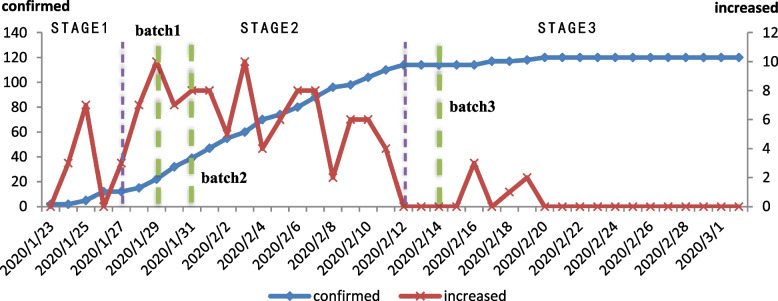
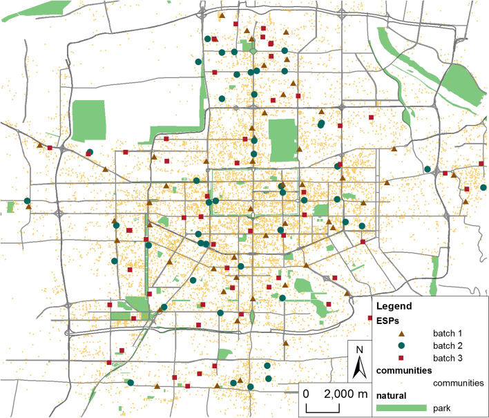
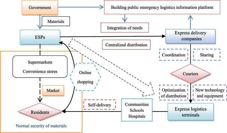
The severe acute respiratory syndrome coronavirus 2 (COVID-19) pandemic has brought a heavy burden and severe challenges to the global economy and society, forcing different countries and regions to take various preventive and control measures ranging from normal operations to partial or complete lockdowns. Taking Xi'an city as an example, based on multisource POI data for the government's vegetable storage delivery points, logistics terminal outlets, designated medical institutions, communities, etc., this paper uses the Gaussian two-step floating catchment area method (2SFCA) and other spatial analysis methods to analyze the spatial pattern of emergency support points (ESPs) and express logistics terminals in different situations. It then discusses construction and optimization strategies for urban emergency support and delivery service systems. The conclusions are as follows. (1) The ESPs are supported by large-scale chain supermarkets and fresh supermarkets, which are positively related to the population distribution.The spatial distribution of express logistics terminals is imbalanced, dense in the middle while sparse at the edges. 90% of express terminals are located within a 500 m distance of communities, however, some terminals are shared, which restrict their ability to provide emergency support to surrounding residents. (2) In general, accessibility increases as the number of ESPs increases; under normal traffic, as the distance threshold increases, the available ESPs increase but accessibility slightly decreases; with a traffic lockdown, the travel distance of residents is limited, and as ESPs increase, accessibility and the number of POIs covered significantly increase. (3) The spatial accessibility of the ESPs has a "dumbbell-shaped" distribution, with highest accessibility in the north and south, higher around the second ring road, slightly lower in the center, and lowest near the third ring road at east and west. (4) With the goal of "opening up the logistics artery and unblocking the distribution microcirculation", based on "ESPs + couriers + express logistics terminals + residents", this paper proposes to build and optimize the urban emergency support and delivery service system to improve the comprehensive ability of the city to cope with uncertain risks.


 分享
分享

 求助内容:
求助内容: 应助结果提醒方式:
 扫码关注我们
