{"title":"(地籍簿的(重新)用途:当教会档案倡导土著土地权利时","authors":"Léa Denieul-Pinsky","doi":"10.1111/cag.12883","DOIUrl":null,"url":null,"abstract":"<p><i>This paper reflects on the potential and limits of repatriating state-sanctioned historical materials and repurposing them as “counter-archives” for Indigenous communities. This proposal aligns itself with the epistemic shift in archival studies which promotes a processual approach to archiving (archive-as-subject) rather than an extractive one (archive-as-source). Instead of taking colonial archives at face value or dismissing them entirely for their erasures, scholars and artists are finding new ways to approach, produce, and share them. This research expands the scope of counter-cartography and historical geography by identifying different data sources that can be mapped. Mandated by a Mohawk Land Defender, I have compiled ecclesiastical archives, cadasters, and land registries from the Seminary of St. Sulpice into a “counter-archive,” then turned them into a geospatial database for use in GIS. Historically these ecclesiastical records were used by the Seminary to claim Indigenous territories, erase Indigenous presence, and attract settlers to the Seigneurie du Lac-des-Deux-Montagnes, an area spanning 540 km<sup>2</sup> west of Montreal. The repurposed counter-archives can be used as tools for critical public discourse around Indigenous land rights. Given genuine Federal will for reconciliation, this methodology mapping land dispossession from archival cadasters and land registries could expand to other locations across Canada.</i></p>","PeriodicalId":47619,"journal":{"name":"Canadian Geographer-Geographe Canadien","volume":"68 3","pages":"306-322"},"PeriodicalIF":1.1000,"publicationDate":"2023-09-20","publicationTypes":"Journal Article","fieldsOfStudy":null,"isOpenAccess":false,"openAccessPdf":"https://onlinelibrary.wiley.com/doi/epdf/10.1111/cag.12883","citationCount":"0","resultStr":"{\"title\":\"(Re)purposing cadasters: When ecclesiastical archives advocate for Indigenous land rights\",\"authors\":\"Léa Denieul-Pinsky\",\"doi\":\"10.1111/cag.12883\",\"DOIUrl\":null,\"url\":null,\"abstract\":\"<p><i>This paper reflects on the potential and limits of repatriating state-sanctioned historical materials and repurposing them as “counter-archives” for Indigenous communities. This proposal aligns itself with the epistemic shift in archival studies which promotes a processual approach to archiving (archive-as-subject) rather than an extractive one (archive-as-source). Instead of taking colonial archives at face value or dismissing them entirely for their erasures, scholars and artists are finding new ways to approach, produce, and share them. This research expands the scope of counter-cartography and historical geography by identifying different data sources that can be mapped. Mandated by a Mohawk Land Defender, I have compiled ecclesiastical archives, cadasters, and land registries from the Seminary of St. Sulpice into a “counter-archive,” then turned them into a geospatial database for use in GIS. Historically these ecclesiastical records were used by the Seminary to claim Indigenous territories, erase Indigenous presence, and attract settlers to the Seigneurie du Lac-des-Deux-Montagnes, an area spanning 540 km<sup>2</sup> west of Montreal. The repurposed counter-archives can be used as tools for critical public discourse around Indigenous land rights. Given genuine Federal will for reconciliation, this methodology mapping land dispossession from archival cadasters and land registries could expand to other locations across Canada.</i></p>\",\"PeriodicalId\":47619,\"journal\":{\"name\":\"Canadian Geographer-Geographe Canadien\",\"volume\":\"68 3\",\"pages\":\"306-322\"},\"PeriodicalIF\":1.1000,\"publicationDate\":\"2023-09-20\",\"publicationTypes\":\"Journal Article\",\"fieldsOfStudy\":null,\"isOpenAccess\":false,\"openAccessPdf\":\"https://onlinelibrary.wiley.com/doi/epdf/10.1111/cag.12883\",\"citationCount\":\"0\",\"resultStr\":null,\"platform\":\"Semanticscholar\",\"paperid\":null,\"PeriodicalName\":\"Canadian Geographer-Geographe Canadien\",\"FirstCategoryId\":\"90\",\"ListUrlMain\":\"https://onlinelibrary.wiley.com/doi/10.1111/cag.12883\",\"RegionNum\":4,\"RegionCategory\":\"社会学\",\"ArticlePicture\":[],\"TitleCN\":null,\"AbstractTextCN\":null,\"PMCID\":null,\"EPubDate\":\"\",\"PubModel\":\"\",\"JCR\":\"Q2\",\"JCRName\":\"GEOGRAPHY\",\"Score\":null,\"Total\":0}","platform":"Semanticscholar","paperid":null,"PeriodicalName":"Canadian Geographer-Geographe Canadien","FirstCategoryId":"90","ListUrlMain":"https://onlinelibrary.wiley.com/doi/10.1111/cag.12883","RegionNum":4,"RegionCategory":"社会学","ArticlePicture":[],"TitleCN":null,"AbstractTextCN":null,"PMCID":null,"EPubDate":"","PubModel":"","JCR":"Q2","JCRName":"GEOGRAPHY","Score":null,"Total":0}
引用次数: 0
摘要
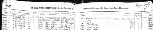
本文反思了将国家认可的历史资料归还并将其重新用作土著社区 "反档案 "的潜力和局限性。这一提议与档案学研究中的认识论转变相一致,即提倡以过程性方法(档案即主体)而非萃取性方法(档案即来源)进行归档。学者和艺术家们不再对殖民档案信手拈来,也不再因其被抹杀而全盘否定,他们正在寻找新的方法来处理、制作和分享这些档案。这项研究通过确定可绘制的不同数据来源,扩大了反地图学和历史地理学的范围。受莫霍克土地卫士的委托,我将圣苏尔皮斯神学院的教会档案、土地清册和土地登记册汇编成 "反档案",然后将其转化为地理空间数据库,供地理信息系统使用。从历史上看,这些教会记录曾被神学院用来索取土著领地、抹杀土著存在并吸引定居者到蒙特利尔以西面积达 540 平方公里的 Seigneurie du Lac-des-Deux-Montagnes 地区定居。经过重新利用的反档案可用作围绕土著土地权利开展批判性公共讨论的工具。如果联邦有真正的和解意愿,这种从档案地籍和土地登记中绘制土地剥夺图的方法可以推广到加拿大其他地方。
(Re)purposing cadasters: When ecclesiastical archives advocate for Indigenous land rights
This paper reflects on the potential and limits of repatriating state-sanctioned historical materials and repurposing them as “counter-archives” for Indigenous communities. This proposal aligns itself with the epistemic shift in archival studies which promotes a processual approach to archiving (archive-as-subject) rather than an extractive one (archive-as-source). Instead of taking colonial archives at face value or dismissing them entirely for their erasures, scholars and artists are finding new ways to approach, produce, and share them. This research expands the scope of counter-cartography and historical geography by identifying different data sources that can be mapped. Mandated by a Mohawk Land Defender, I have compiled ecclesiastical archives, cadasters, and land registries from the Seminary of St. Sulpice into a “counter-archive,” then turned them into a geospatial database for use in GIS. Historically these ecclesiastical records were used by the Seminary to claim Indigenous territories, erase Indigenous presence, and attract settlers to the Seigneurie du Lac-des-Deux-Montagnes, an area spanning 540 km2 west of Montreal. The repurposed counter-archives can be used as tools for critical public discourse around Indigenous land rights. Given genuine Federal will for reconciliation, this methodology mapping land dispossession from archival cadasters and land registries could expand to other locations across Canada.


 分享
分享
 求助内容:
求助内容: 应助结果提醒方式:
 扫码关注我们
