{"title":"船载重力和水磁测量在解决陆架工程地质问题中的可能性","authors":"M. V. Kochetov, A. A. Shepelev, S. V. Chelyshev","doi":"10.3103/s0145875223040087","DOIUrl":null,"url":null,"abstract":"<h3 data-test=\"abstract-sub-heading\">Abstract</h3><p>The possibilities of using on-board gravimetry and hydromagnetometry together with high-resolution seismic surveying in the framework of engineering-geological surveying in the Arctic shelf area of the Russian Federation are considered. The surveys were carried out in the southern part of the Kara Sea shelf in a study area of 25 km<sup>2</sup> in order to identify potentially hazardous zones for setting up a floating drilling rig. The studies were carried out using a regular survey grid, consisting of 51 row and 26 secant profiles. The length of each profile was 5 km. The gravity surveys were performed with a Chekan-AM marine on-board gravimeter. The magnetometer surveys were conducted using SeaSPY 2 towed marine magnetometers. The dense survey grid, high-precision equipment, and field work procedure made it possible to obtain high accuracy of surveys: 0.14 mGal and 1.12 nT. The depth of research in engineering-geological surveying by the presented set of methods varied from the first hundred meters to 1 km. The long-term experience in engineering-geological surveys in the Arctic shelf area by personnel of Marine Arctic Exploration Expedition JSC shows that paleoincisons and paleovalleys are common hazards of a geological nature in this region. These structures are conventionally filled with weakly consolidated, often gas-saturated, sediments with inclusions of large-rock fragments. Paleoincisions clearly manifest themselves in the high-frequency component of the magnetic field; the local component of the anomalous magnetic field was calculated to detect them. As a result of complex interpretation of gravity field anomalies and magnetic survey data, a curved linear zone intersecting the entire study area has been localized. The identified anomalous zone is confined to the boundaries of the paleoincision, which was originally discovered according to the data of seismoacoustic studies. Based on the results of interpreting the magnetometer surveys, an area of negative magnetic anomalies was found in the eastern part of the study area. According to the materials of seismoacoustic studies, paleoincisions of a complex spatial and deep configuration are traced in this zone. It is noteworthy that these structures do not occur in the magnetic field. Based on the obtained values of the gravity field and seismoacoustic data, a seismic-density section of meridional strike was constructed across the entire area. As a result of 2D seismo-density modeling, the densities for the undercut paleoincision were selected and two decompacted areas were found at a depth of 200 m. The decompacted areas can be caused by the gas saturation of the sedimentary stratum and need to be considered in installing a floating drilling rig. The interpretation of the anomalous gravity field in the specified complex of geophysical methods with a priori geological information allows the prediction of the density structure of the study rock mass and provides recommendations for future research.</p>","PeriodicalId":44391,"journal":{"name":"Moscow University Geology Bulletin","volume":"5 1","pages":""},"PeriodicalIF":0.3000,"publicationDate":"2023-11-16","publicationTypes":"Journal Article","fieldsOfStudy":null,"isOpenAccess":false,"openAccessPdf":"","citationCount":"0","resultStr":"{\"title\":\"The Possibilities of On-Board Gravimetric and Hydromagnetic Surveys in Solving Engineering-Geological Problems on the Shelf\",\"authors\":\"M. V. Kochetov, A. A. Shepelev, S. V. Chelyshev\",\"doi\":\"10.3103/s0145875223040087\",\"DOIUrl\":null,\"url\":null,\"abstract\":\"<h3 data-test=\\\"abstract-sub-heading\\\">Abstract</h3><p>The possibilities of using on-board gravimetry and hydromagnetometry together with high-resolution seismic surveying in the framework of engineering-geological surveying in the Arctic shelf area of the Russian Federation are considered. The surveys were carried out in the southern part of the Kara Sea shelf in a study area of 25 km<sup>2</sup> in order to identify potentially hazardous zones for setting up a floating drilling rig. The studies were carried out using a regular survey grid, consisting of 51 row and 26 secant profiles. The length of each profile was 5 km. The gravity surveys were performed with a Chekan-AM marine on-board gravimeter. The magnetometer surveys were conducted using SeaSPY 2 towed marine magnetometers. The dense survey grid, high-precision equipment, and field work procedure made it possible to obtain high accuracy of surveys: 0.14 mGal and 1.12 nT. The depth of research in engineering-geological surveying by the presented set of methods varied from the first hundred meters to 1 km. The long-term experience in engineering-geological surveys in the Arctic shelf area by personnel of Marine Arctic Exploration Expedition JSC shows that paleoincisons and paleovalleys are common hazards of a geological nature in this region. These structures are conventionally filled with weakly consolidated, often gas-saturated, sediments with inclusions of large-rock fragments. Paleoincisions clearly manifest themselves in the high-frequency component of the magnetic field; the local component of the anomalous magnetic field was calculated to detect them. As a result of complex interpretation of gravity field anomalies and magnetic survey data, a curved linear zone intersecting the entire study area has been localized. The identified anomalous zone is confined to the boundaries of the paleoincision, which was originally discovered according to the data of seismoacoustic studies. Based on the results of interpreting the magnetometer surveys, an area of negative magnetic anomalies was found in the eastern part of the study area. According to the materials of seismoacoustic studies, paleoincisions of a complex spatial and deep configuration are traced in this zone. It is noteworthy that these structures do not occur in the magnetic field. Based on the obtained values of the gravity field and seismoacoustic data, a seismic-density section of meridional strike was constructed across the entire area. As a result of 2D seismo-density modeling, the densities for the undercut paleoincision were selected and two decompacted areas were found at a depth of 200 m. The decompacted areas can be caused by the gas saturation of the sedimentary stratum and need to be considered in installing a floating drilling rig. The interpretation of the anomalous gravity field in the specified complex of geophysical methods with a priori geological information allows the prediction of the density structure of the study rock mass and provides recommendations for future research.</p>\",\"PeriodicalId\":44391,\"journal\":{\"name\":\"Moscow University Geology Bulletin\",\"volume\":\"5 1\",\"pages\":\"\"},\"PeriodicalIF\":0.3000,\"publicationDate\":\"2023-11-16\",\"publicationTypes\":\"Journal Article\",\"fieldsOfStudy\":null,\"isOpenAccess\":false,\"openAccessPdf\":\"\",\"citationCount\":\"0\",\"resultStr\":null,\"platform\":\"Semanticscholar\",\"paperid\":null,\"PeriodicalName\":\"Moscow University Geology Bulletin\",\"FirstCategoryId\":\"1085\",\"ListUrlMain\":\"https://doi.org/10.3103/s0145875223040087\",\"RegionNum\":0,\"RegionCategory\":null,\"ArticlePicture\":[],\"TitleCN\":null,\"AbstractTextCN\":null,\"PMCID\":null,\"EPubDate\":\"\",\"PubModel\":\"\",\"JCR\":\"Q4\",\"JCRName\":\"GEOLOGY\",\"Score\":null,\"Total\":0}","platform":"Semanticscholar","paperid":null,"PeriodicalName":"Moscow University Geology Bulletin","FirstCategoryId":"1085","ListUrlMain":"https://doi.org/10.3103/s0145875223040087","RegionNum":0,"RegionCategory":null,"ArticlePicture":[],"TitleCN":null,"AbstractTextCN":null,"PMCID":null,"EPubDate":"","PubModel":"","JCR":"Q4","JCRName":"GEOLOGY","Score":null,"Total":0}
The Possibilities of On-Board Gravimetric and Hydromagnetic Surveys in Solving Engineering-Geological Problems on the Shelf
Abstract
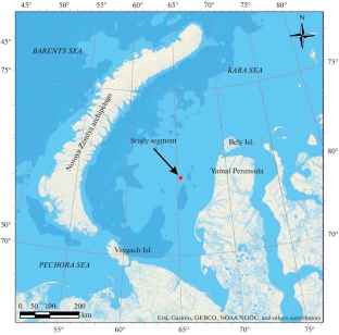
The possibilities of using on-board gravimetry and hydromagnetometry together with high-resolution seismic surveying in the framework of engineering-geological surveying in the Arctic shelf area of the Russian Federation are considered. The surveys were carried out in the southern part of the Kara Sea shelf in a study area of 25 km2 in order to identify potentially hazardous zones for setting up a floating drilling rig. The studies were carried out using a regular survey grid, consisting of 51 row and 26 secant profiles. The length of each profile was 5 km. The gravity surveys were performed with a Chekan-AM marine on-board gravimeter. The magnetometer surveys were conducted using SeaSPY 2 towed marine magnetometers. The dense survey grid, high-precision equipment, and field work procedure made it possible to obtain high accuracy of surveys: 0.14 mGal and 1.12 nT. The depth of research in engineering-geological surveying by the presented set of methods varied from the first hundred meters to 1 km. The long-term experience in engineering-geological surveys in the Arctic shelf area by personnel of Marine Arctic Exploration Expedition JSC shows that paleoincisons and paleovalleys are common hazards of a geological nature in this region. These structures are conventionally filled with weakly consolidated, often gas-saturated, sediments with inclusions of large-rock fragments. Paleoincisions clearly manifest themselves in the high-frequency component of the magnetic field; the local component of the anomalous magnetic field was calculated to detect them. As a result of complex interpretation of gravity field anomalies and magnetic survey data, a curved linear zone intersecting the entire study area has been localized. The identified anomalous zone is confined to the boundaries of the paleoincision, which was originally discovered according to the data of seismoacoustic studies. Based on the results of interpreting the magnetometer surveys, an area of negative magnetic anomalies was found in the eastern part of the study area. According to the materials of seismoacoustic studies, paleoincisions of a complex spatial and deep configuration are traced in this zone. It is noteworthy that these structures do not occur in the magnetic field. Based on the obtained values of the gravity field and seismoacoustic data, a seismic-density section of meridional strike was constructed across the entire area. As a result of 2D seismo-density modeling, the densities for the undercut paleoincision were selected and two decompacted areas were found at a depth of 200 m. The decompacted areas can be caused by the gas saturation of the sedimentary stratum and need to be considered in installing a floating drilling rig. The interpretation of the anomalous gravity field in the specified complex of geophysical methods with a priori geological information allows the prediction of the density structure of the study rock mass and provides recommendations for future research.
期刊介绍:
Moscow University Geology Bulletin is the journal that mainly publishes scientific articles, short reports of graduate students, and reviews. Publications made by the members of the Faculty of Geology of the Moscow State University and their collaborators are published. Publications encompass all branches of geology.


 分享
分享
 求助内容:
求助内容: 应助结果提醒方式:
 扫码关注我们
