{"title":"基于全景视频自适应视点选择的三维城市场景重建增强方法","authors":"Xujie Zhang, Zhenbiao Hu, Qingwu Hu, Jun Zhao, Mingyao Ai, Pengcheng Zhao, Jiayuan Li, Xiaojie Zhou, Zongqiang Chen","doi":"10.1111/phor.12467","DOIUrl":null,"url":null,"abstract":"The widely used unmanned aerial vehicle oblique photogrammetry often suffers from information loss in complex urban environments, leading to geometric and textural defects in the resulting models. In this study, a close-range panoramic optimal viewpoint selection assisted 3D urban scene reconstruction enhancement method is proposed for areas prone to defects. We first introduce the ground panoramic data acquisition equipment and strategy, which are different from those of the single-lens supplementary photography method. Data acquisition is accomplished through a single and continuous surround-style collection approach. The full coverage of the panoramic video in the space–time dimension enables the acquisition of texture details without considering camera station planning. Then, a panoramic multiview image generation approach is proposed. Adaptive viewpoint selection is achieved using unbiased sampling points from the rough scene model, and viewpoint optimisation is adopted to ensure sufficient image overlap and intersection effects, thus improving the scene reconstructability. Finally, the 3D model is generated by photogrammetric processing of the panoramic multiview images, resulting in an enhanced modelling effect. To validate the proposed method, we conducted experiments using real data from Qingdao, China. Both the qualitative and quantitative results demonstrate a significant improvement in the quality of geometric and textural reconstruction. The tie-point reprojection errors are less than 1 pixel, and the registration accuracy with the model from oblique photogrammetry is comparable to that of optimised-view photography. By eliminating the need for on-site camera station planning or manual flight operations and effectively minimising the redundancy of panoramic videos, our approach significantly reduces the photography and computation costs associated with reconstruction enhancement. Thus, it presents a feasible technical solution for the generation of urban 3D fine models.","PeriodicalId":22881,"journal":{"name":"The Photogrammetric Record","volume":"38 1","pages":""},"PeriodicalIF":0.0000,"publicationDate":"2024-01-07","publicationTypes":"Journal Article","fieldsOfStudy":null,"isOpenAccess":false,"openAccessPdf":"","citationCount":"0","resultStr":"{\"title\":\"A 3D urban scene reconstruction enhancement approach based on adaptive viewpoint selection of panoramic videos\",\"authors\":\"Xujie Zhang, Zhenbiao Hu, Qingwu Hu, Jun Zhao, Mingyao Ai, Pengcheng Zhao, Jiayuan Li, Xiaojie Zhou, Zongqiang Chen\",\"doi\":\"10.1111/phor.12467\",\"DOIUrl\":null,\"url\":null,\"abstract\":\"The widely used unmanned aerial vehicle oblique photogrammetry often suffers from information loss in complex urban environments, leading to geometric and textural defects in the resulting models. In this study, a close-range panoramic optimal viewpoint selection assisted 3D urban scene reconstruction enhancement method is proposed for areas prone to defects. We first introduce the ground panoramic data acquisition equipment and strategy, which are different from those of the single-lens supplementary photography method. Data acquisition is accomplished through a single and continuous surround-style collection approach. The full coverage of the panoramic video in the space–time dimension enables the acquisition of texture details without considering camera station planning. Then, a panoramic multiview image generation approach is proposed. Adaptive viewpoint selection is achieved using unbiased sampling points from the rough scene model, and viewpoint optimisation is adopted to ensure sufficient image overlap and intersection effects, thus improving the scene reconstructability. Finally, the 3D model is generated by photogrammetric processing of the panoramic multiview images, resulting in an enhanced modelling effect. To validate the proposed method, we conducted experiments using real data from Qingdao, China. Both the qualitative and quantitative results demonstrate a significant improvement in the quality of geometric and textural reconstruction. The tie-point reprojection errors are less than 1 pixel, and the registration accuracy with the model from oblique photogrammetry is comparable to that of optimised-view photography. By eliminating the need for on-site camera station planning or manual flight operations and effectively minimising the redundancy of panoramic videos, our approach significantly reduces the photography and computation costs associated with reconstruction enhancement. Thus, it presents a feasible technical solution for the generation of urban 3D fine models.\",\"PeriodicalId\":22881,\"journal\":{\"name\":\"The Photogrammetric Record\",\"volume\":\"38 1\",\"pages\":\"\"},\"PeriodicalIF\":0.0000,\"publicationDate\":\"2024-01-07\",\"publicationTypes\":\"Journal Article\",\"fieldsOfStudy\":null,\"isOpenAccess\":false,\"openAccessPdf\":\"\",\"citationCount\":\"0\",\"resultStr\":null,\"platform\":\"Semanticscholar\",\"paperid\":null,\"PeriodicalName\":\"The Photogrammetric Record\",\"FirstCategoryId\":\"1085\",\"ListUrlMain\":\"https://doi.org/10.1111/phor.12467\",\"RegionNum\":0,\"RegionCategory\":null,\"ArticlePicture\":[],\"TitleCN\":null,\"AbstractTextCN\":null,\"PMCID\":null,\"EPubDate\":\"\",\"PubModel\":\"\",\"JCR\":\"\",\"JCRName\":\"\",\"Score\":null,\"Total\":0}","platform":"Semanticscholar","paperid":null,"PeriodicalName":"The Photogrammetric Record","FirstCategoryId":"1085","ListUrlMain":"https://doi.org/10.1111/phor.12467","RegionNum":0,"RegionCategory":null,"ArticlePicture":[],"TitleCN":null,"AbstractTextCN":null,"PMCID":null,"EPubDate":"","PubModel":"","JCR":"","JCRName":"","Score":null,"Total":0}
A 3D urban scene reconstruction enhancement approach based on adaptive viewpoint selection of panoramic videos
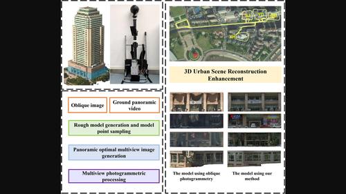
The widely used unmanned aerial vehicle oblique photogrammetry often suffers from information loss in complex urban environments, leading to geometric and textural defects in the resulting models. In this study, a close-range panoramic optimal viewpoint selection assisted 3D urban scene reconstruction enhancement method is proposed for areas prone to defects. We first introduce the ground panoramic data acquisition equipment and strategy, which are different from those of the single-lens supplementary photography method. Data acquisition is accomplished through a single and continuous surround-style collection approach. The full coverage of the panoramic video in the space–time dimension enables the acquisition of texture details without considering camera station planning. Then, a panoramic multiview image generation approach is proposed. Adaptive viewpoint selection is achieved using unbiased sampling points from the rough scene model, and viewpoint optimisation is adopted to ensure sufficient image overlap and intersection effects, thus improving the scene reconstructability. Finally, the 3D model is generated by photogrammetric processing of the panoramic multiview images, resulting in an enhanced modelling effect. To validate the proposed method, we conducted experiments using real data from Qingdao, China. Both the qualitative and quantitative results demonstrate a significant improvement in the quality of geometric and textural reconstruction. The tie-point reprojection errors are less than 1 pixel, and the registration accuracy with the model from oblique photogrammetry is comparable to that of optimised-view photography. By eliminating the need for on-site camera station planning or manual flight operations and effectively minimising the redundancy of panoramic videos, our approach significantly reduces the photography and computation costs associated with reconstruction enhancement. Thus, it presents a feasible technical solution for the generation of urban 3D fine models.


 分享
分享

 求助内容:
求助内容: 应助结果提醒方式:
 扫码关注我们
