Soledad María Nomdedeu, Joaquín Orzanco, Patricia Kandus
{"title":"南美洲温带潘帕斯地貌农牧业核心区的湿地分布。土壤制图方法","authors":"Soledad María Nomdedeu, Joaquín Orzanco, Patricia Kandus","doi":"10.1007/s11273-023-09972-x","DOIUrl":null,"url":null,"abstract":"<p>Expansion and intensification of agriculture are among the main factors of degradation and systematic loss of wetlands throughout the twentieth century. We analyze the potential occurrence of wetlands in the core area of the temperate Pampas region of South America, recognized for the quality of its pastures and the suitability of its soils for grain production. We mapped the spatial distribution of wetlands in the Province of Buenos Aires based on the analysis and classification of the local soil database at a scale of 1:50,000. Thus, 399 soil series were classified as hydric/non-hydric according to the scope of methods and criteria reviewed. Then we used this information to classify 2211 map units into five categories based on the percentage of hydric and non-hydric soil series: 1—hydric (100% hydric series); 2—predominantly hydric (66–99% hydric series); 3—partially hydric (33–65% hydric series); 4—predominantly non-hydric (1–32% hydric series); and 5—non-hydric (0% hydric series). We estimated wetlands cover about 35% of the province. Wetlands distribution is not uniform, we identified three main landscapes: terrestrial matrix with wetlands, mosaic of wetlands and non-wetlands, and mosaic dominated by wetland patches. Our results provide tools for land management in terms of strategies for a wise use of wetlands and their conservation. Our map shows high values of consistency with the occurrence of wetlands visually identified in high-resolution imagery (Google Earth platform). In such a highly agriculturized landscape, our results indicate a much larger wetland area compared to estimates made with optical remote sensing data classifications. </p>","PeriodicalId":49363,"journal":{"name":"Wetlands Ecology and Management","volume":"211 1","pages":""},"PeriodicalIF":1.6000,"publicationDate":"2024-01-12","publicationTypes":"Journal Article","fieldsOfStudy":null,"isOpenAccess":false,"openAccessPdf":"","citationCount":"0","resultStr":"{\"title\":\"Wetlands distribution in the agricultural-livestock core of the South American temperate pampas landscape. Approach from soil cartography\",\"authors\":\"Soledad María Nomdedeu, Joaquín Orzanco, Patricia Kandus\",\"doi\":\"10.1007/s11273-023-09972-x\",\"DOIUrl\":null,\"url\":null,\"abstract\":\"<p>Expansion and intensification of agriculture are among the main factors of degradation and systematic loss of wetlands throughout the twentieth century. We analyze the potential occurrence of wetlands in the core area of the temperate Pampas region of South America, recognized for the quality of its pastures and the suitability of its soils for grain production. We mapped the spatial distribution of wetlands in the Province of Buenos Aires based on the analysis and classification of the local soil database at a scale of 1:50,000. Thus, 399 soil series were classified as hydric/non-hydric according to the scope of methods and criteria reviewed. Then we used this information to classify 2211 map units into five categories based on the percentage of hydric and non-hydric soil series: 1—hydric (100% hydric series); 2—predominantly hydric (66–99% hydric series); 3—partially hydric (33–65% hydric series); 4—predominantly non-hydric (1–32% hydric series); and 5—non-hydric (0% hydric series). We estimated wetlands cover about 35% of the province. Wetlands distribution is not uniform, we identified three main landscapes: terrestrial matrix with wetlands, mosaic of wetlands and non-wetlands, and mosaic dominated by wetland patches. Our results provide tools for land management in terms of strategies for a wise use of wetlands and their conservation. Our map shows high values of consistency with the occurrence of wetlands visually identified in high-resolution imagery (Google Earth platform). In such a highly agriculturized landscape, our results indicate a much larger wetland area compared to estimates made with optical remote sensing data classifications. </p>\",\"PeriodicalId\":49363,\"journal\":{\"name\":\"Wetlands Ecology and Management\",\"volume\":\"211 1\",\"pages\":\"\"},\"PeriodicalIF\":1.6000,\"publicationDate\":\"2024-01-12\",\"publicationTypes\":\"Journal Article\",\"fieldsOfStudy\":null,\"isOpenAccess\":false,\"openAccessPdf\":\"\",\"citationCount\":\"0\",\"resultStr\":null,\"platform\":\"Semanticscholar\",\"paperid\":null,\"PeriodicalName\":\"Wetlands Ecology and Management\",\"FirstCategoryId\":\"93\",\"ListUrlMain\":\"https://doi.org/10.1007/s11273-023-09972-x\",\"RegionNum\":4,\"RegionCategory\":\"环境科学与生态学\",\"ArticlePicture\":[],\"TitleCN\":null,\"AbstractTextCN\":null,\"PMCID\":null,\"EPubDate\":\"\",\"PubModel\":\"\",\"JCR\":\"Q4\",\"JCRName\":\"ENVIRONMENTAL SCIENCES\",\"Score\":null,\"Total\":0}","platform":"Semanticscholar","paperid":null,"PeriodicalName":"Wetlands Ecology and Management","FirstCategoryId":"93","ListUrlMain":"https://doi.org/10.1007/s11273-023-09972-x","RegionNum":4,"RegionCategory":"环境科学与生态学","ArticlePicture":[],"TitleCN":null,"AbstractTextCN":null,"PMCID":null,"EPubDate":"","PubModel":"","JCR":"Q4","JCRName":"ENVIRONMENTAL SCIENCES","Score":null,"Total":0}
Wetlands distribution in the agricultural-livestock core of the South American temperate pampas landscape. Approach from soil cartography
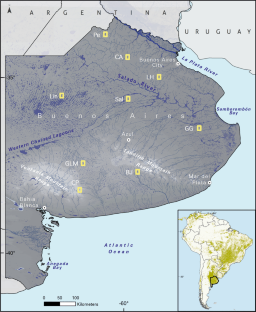
Expansion and intensification of agriculture are among the main factors of degradation and systematic loss of wetlands throughout the twentieth century. We analyze the potential occurrence of wetlands in the core area of the temperate Pampas region of South America, recognized for the quality of its pastures and the suitability of its soils for grain production. We mapped the spatial distribution of wetlands in the Province of Buenos Aires based on the analysis and classification of the local soil database at a scale of 1:50,000. Thus, 399 soil series were classified as hydric/non-hydric according to the scope of methods and criteria reviewed. Then we used this information to classify 2211 map units into five categories based on the percentage of hydric and non-hydric soil series: 1—hydric (100% hydric series); 2—predominantly hydric (66–99% hydric series); 3—partially hydric (33–65% hydric series); 4—predominantly non-hydric (1–32% hydric series); and 5—non-hydric (0% hydric series). We estimated wetlands cover about 35% of the province. Wetlands distribution is not uniform, we identified three main landscapes: terrestrial matrix with wetlands, mosaic of wetlands and non-wetlands, and mosaic dominated by wetland patches. Our results provide tools for land management in terms of strategies for a wise use of wetlands and their conservation. Our map shows high values of consistency with the occurrence of wetlands visually identified in high-resolution imagery (Google Earth platform). In such a highly agriculturized landscape, our results indicate a much larger wetland area compared to estimates made with optical remote sensing data classifications.
期刊介绍:
Wetlands Ecology and Management is an international journal that publishes authoritative and original articles on topics relevant to freshwater, brackish and marine coastal wetland ecosystems. The Journal serves as a multi-disciplinary forum covering key issues in wetlands science, management, policy and economics. As such, Wetlands Ecology and Management aims to encourage the exchange of information between environmental managers, pure and applied scientists, and national and international authorities on wetlands policy and ecological economics.


 分享
分享
 求助内容:
求助内容: 应助结果提醒方式:
 扫码关注我们
