Nels R. Bjarke, Ben Livneh, Joseph J. Barsugli, Angeline G. Pendergrass, Eric E. Small
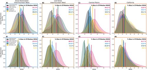
{"title":"评估美国西部毗连地区高分辨率大气环流模型和观测数据中的大暴雨优势","authors":"Nels R. Bjarke, Ben Livneh, Joseph J. Barsugli, Angeline G. Pendergrass, Eric E. Small","doi":"10.1029/2023EF004289","DOIUrl":null,"url":null,"abstract":"<p>Extreme precipitation events are projected to increase in frequency across much of the land-surface as the global climate warms, but such projections have typically relied on coarse-resolution (100–250 km) general circulation models (GCMs). The ensemble of HighResMIP GCMs presents an opportunity to evaluate how a more finely resolved atmosphere and land-surface might enhance the fidelity of the simulated contribution of large-magnitude storms to total precipitation, particularly across topographically complex terrain. Here, the simulation of large-storm dominance, that is, the number of wettest days to reach half of the total annual precipitation, is quantified across the western United States (WUS) using four GCMs within the HighResMIP ensemble and their coarse resolution counterparts. Historical GCM simulations (1950–2014) are evaluated against a baseline generated from station-observed daily precipitation (4,803 GHCN-D stations) and from three gridded, observationally based precipitation data sets that are coarsened to match the resolution of the GCMs. All coarse-resolution simulations produce less large-storm dominance than in observations across the WUS. For two of the four GCMs, bias in the median large-storm dominance is reduced in the HighResMIP simulation, decreasing by as much as 62% in the intermountain west region. However, the other GCMs show little change or even an increase (+28%) in bias of median large-storm dominance across multiple sub-regions. The spread in differences with resolution amongst GCMs suggests that, in addition to resolution, model structure and parameterization of precipitation generating processes also contribute to bias in simulated large-storm dominance.</p>","PeriodicalId":48748,"journal":{"name":"Earths Future","volume":"12 6","pages":""},"PeriodicalIF":8.2000,"publicationDate":"2024-06-26","publicationTypes":"Journal Article","fieldsOfStudy":null,"isOpenAccess":false,"openAccessPdf":"https://onlinelibrary.wiley.com/doi/epdf/10.1029/2023EF004289","citationCount":"0","resultStr":"{\"title\":\"Evaluating Large-Storm Dominance in High-Resolution GCMs and Observations Across the Western Contiguous United States\",\"authors\":\"Nels R. Bjarke, Ben Livneh, Joseph J. Barsugli, Angeline G. Pendergrass, Eric E. Small\",\"doi\":\"10.1029/2023EF004289\",\"DOIUrl\":null,\"url\":null,\"abstract\":\"<p>Extreme precipitation events are projected to increase in frequency across much of the land-surface as the global climate warms, but such projections have typically relied on coarse-resolution (100–250 km) general circulation models (GCMs). The ensemble of HighResMIP GCMs presents an opportunity to evaluate how a more finely resolved atmosphere and land-surface might enhance the fidelity of the simulated contribution of large-magnitude storms to total precipitation, particularly across topographically complex terrain. Here, the simulation of large-storm dominance, that is, the number of wettest days to reach half of the total annual precipitation, is quantified across the western United States (WUS) using four GCMs within the HighResMIP ensemble and their coarse resolution counterparts. Historical GCM simulations (1950–2014) are evaluated against a baseline generated from station-observed daily precipitation (4,803 GHCN-D stations) and from three gridded, observationally based precipitation data sets that are coarsened to match the resolution of the GCMs. All coarse-resolution simulations produce less large-storm dominance than in observations across the WUS. For two of the four GCMs, bias in the median large-storm dominance is reduced in the HighResMIP simulation, decreasing by as much as 62% in the intermountain west region. However, the other GCMs show little change or even an increase (+28%) in bias of median large-storm dominance across multiple sub-regions. The spread in differences with resolution amongst GCMs suggests that, in addition to resolution, model structure and parameterization of precipitation generating processes also contribute to bias in simulated large-storm dominance.</p>\",\"PeriodicalId\":48748,\"journal\":{\"name\":\"Earths Future\",\"volume\":\"12 6\",\"pages\":\"\"},\"PeriodicalIF\":8.2000,\"publicationDate\":\"2024-06-26\",\"publicationTypes\":\"Journal Article\",\"fieldsOfStudy\":null,\"isOpenAccess\":false,\"openAccessPdf\":\"https://onlinelibrary.wiley.com/doi/epdf/10.1029/2023EF004289\",\"citationCount\":\"0\",\"resultStr\":null,\"platform\":\"Semanticscholar\",\"paperid\":null,\"PeriodicalName\":\"Earths Future\",\"FirstCategoryId\":\"89\",\"ListUrlMain\":\"https://agupubs.onlinelibrary.wiley.com/doi/10.1029/2023EF004289\",\"RegionNum\":1,\"RegionCategory\":\"地球科学\",\"ArticlePicture\":[],\"TitleCN\":null,\"AbstractTextCN\":null,\"PMCID\":null,\"EPubDate\":\"\",\"PubModel\":\"\",\"JCR\":\"Q1\",\"JCRName\":\"ENVIRONMENTAL SCIENCES\",\"Score\":null,\"Total\":0}","platform":"Semanticscholar","paperid":null,"PeriodicalName":"Earths Future","FirstCategoryId":"89","ListUrlMain":"https://agupubs.onlinelibrary.wiley.com/doi/10.1029/2023EF004289","RegionNum":1,"RegionCategory":"地球科学","ArticlePicture":[],"TitleCN":null,"AbstractTextCN":null,"PMCID":null,"EPubDate":"","PubModel":"","JCR":"Q1","JCRName":"ENVIRONMENTAL SCIENCES","Score":null,"Total":0}
Evaluating Large-Storm Dominance in High-Resolution GCMs and Observations Across the Western Contiguous United States
Extreme precipitation events are projected to increase in frequency across much of the land-surface as the global climate warms, but such projections have typically relied on coarse-resolution (100–250 km) general circulation models (GCMs). The ensemble of HighResMIP GCMs presents an opportunity to evaluate how a more finely resolved atmosphere and land-surface might enhance the fidelity of the simulated contribution of large-magnitude storms to total precipitation, particularly across topographically complex terrain. Here, the simulation of large-storm dominance, that is, the number of wettest days to reach half of the total annual precipitation, is quantified across the western United States (WUS) using four GCMs within the HighResMIP ensemble and their coarse resolution counterparts. Historical GCM simulations (1950–2014) are evaluated against a baseline generated from station-observed daily precipitation (4,803 GHCN-D stations) and from three gridded, observationally based precipitation data sets that are coarsened to match the resolution of the GCMs. All coarse-resolution simulations produce less large-storm dominance than in observations across the WUS. For two of the four GCMs, bias in the median large-storm dominance is reduced in the HighResMIP simulation, decreasing by as much as 62% in the intermountain west region. However, the other GCMs show little change or even an increase (+28%) in bias of median large-storm dominance across multiple sub-regions. The spread in differences with resolution amongst GCMs suggests that, in addition to resolution, model structure and parameterization of precipitation generating processes also contribute to bias in simulated large-storm dominance.
期刊介绍:
Earth’s Future: A transdisciplinary open access journal, Earth’s Future focuses on the state of the Earth and the prediction of the planet’s future. By publishing peer-reviewed articles as well as editorials, essays, reviews, and commentaries, this journal will be the preeminent scholarly resource on the Anthropocene. It will also help assess the risks and opportunities associated with environmental changes and challenges.


 分享
分享
 求助内容:
求助内容: 应助结果提醒方式:
 扫码关注我们
