J. Selvin Pitchaikani, Subbareddy Bonthu, R. Muruganandam, C. Viswanathan, K. K. Manodheepan, V. Deepak Samuel, Purvaja Ramachandran, R. Ramesh
{"title":"评估印度西海岸蓝旗海滩的形态特征和保护策略","authors":"J. Selvin Pitchaikani, Subbareddy Bonthu, R. Muruganandam, C. Viswanathan, K. K. Manodheepan, V. Deepak Samuel, Purvaja Ramachandran, R. Ramesh","doi":"10.1007/s11852-024-01054-1","DOIUrl":null,"url":null,"abstract":"<p>Beach morphology assessment is very important for the sustainable development of beaches and the implementation of beach development activities through management plans. The present study focuses on assessing beach morphology and developing ecosystem-based conservative strategies to control beach erosion and improve beach safety along the two blue-flag certified beaches, Padubidri and Kasarkod, in Karnataka state. The bathymetry of the two beaches varies by gradient changes between the winter and monsoon seasons, and as a result, waves break at a distance of 15–25 m from the shore. The estimated seabed deposition between the winter and monsoon periods of 2020 is 10329 cu m and 59.36 cu m at the Padubidri and Kasarkod beaches, respectively. This study also provides the rate of shoreline change at two beaches along the coast for the period 2018–2022, as measured using geospatial technology and field investigation. The assessment revealed that the Kasarkod and Padubidri coasts experienced maximum erosion of 11.7% and 12.7%, respectively for five years. The projected shoreline changes under the climate change show erosion of 59.12 m on the northern side and accretion of about 16.13 m on the southern side of Kasarkod Beach, whereas on Padubidri Beach, erosion of 40 m on the central part of the beach between 2020 and 2030. The nearshore current magnitude is stronger at the coast of Padubidri than at Kasarkod during the study. The sediment movement from the Kamini River at the Hejamadi endpoint (southern part of Padubidri) shapes the Padubidri beach and causes accretion and erosion during winter and monsoon seasons respectively. However, these beaches are being protected by ecosystem-based conservative strategies such as beach vegetation and dune conservation through the Beach Environment and Aesthetics Management Services (BEAMS) program. Therefore, the assessment of beach morphology and conservation strategies provides a better beach management plan, to control beach erosion, and enhance beach stability.</p>","PeriodicalId":48909,"journal":{"name":"Journal of Coastal Conservation","volume":"61 1","pages":""},"PeriodicalIF":1.9000,"publicationDate":"2024-06-22","publicationTypes":"Journal Article","fieldsOfStudy":null,"isOpenAccess":false,"openAccessPdf":"","citationCount":"0","resultStr":"{\"title\":\"Assessment of beach morphological characteristics and conservation strategies for blue flag beaches on the West Coast of India\",\"authors\":\"J. Selvin Pitchaikani, Subbareddy Bonthu, R. Muruganandam, C. Viswanathan, K. K. Manodheepan, V. Deepak Samuel, Purvaja Ramachandran, R. Ramesh\",\"doi\":\"10.1007/s11852-024-01054-1\",\"DOIUrl\":null,\"url\":null,\"abstract\":\"<p>Beach morphology assessment is very important for the sustainable development of beaches and the implementation of beach development activities through management plans. The present study focuses on assessing beach morphology and developing ecosystem-based conservative strategies to control beach erosion and improve beach safety along the two blue-flag certified beaches, Padubidri and Kasarkod, in Karnataka state. The bathymetry of the two beaches varies by gradient changes between the winter and monsoon seasons, and as a result, waves break at a distance of 15–25 m from the shore. The estimated seabed deposition between the winter and monsoon periods of 2020 is 10329 cu m and 59.36 cu m at the Padubidri and Kasarkod beaches, respectively. This study also provides the rate of shoreline change at two beaches along the coast for the period 2018–2022, as measured using geospatial technology and field investigation. The assessment revealed that the Kasarkod and Padubidri coasts experienced maximum erosion of 11.7% and 12.7%, respectively for five years. The projected shoreline changes under the climate change show erosion of 59.12 m on the northern side and accretion of about 16.13 m on the southern side of Kasarkod Beach, whereas on Padubidri Beach, erosion of 40 m on the central part of the beach between 2020 and 2030. The nearshore current magnitude is stronger at the coast of Padubidri than at Kasarkod during the study. The sediment movement from the Kamini River at the Hejamadi endpoint (southern part of Padubidri) shapes the Padubidri beach and causes accretion and erosion during winter and monsoon seasons respectively. However, these beaches are being protected by ecosystem-based conservative strategies such as beach vegetation and dune conservation through the Beach Environment and Aesthetics Management Services (BEAMS) program. Therefore, the assessment of beach morphology and conservation strategies provides a better beach management plan, to control beach erosion, and enhance beach stability.</p>\",\"PeriodicalId\":48909,\"journal\":{\"name\":\"Journal of Coastal Conservation\",\"volume\":\"61 1\",\"pages\":\"\"},\"PeriodicalIF\":1.9000,\"publicationDate\":\"2024-06-22\",\"publicationTypes\":\"Journal Article\",\"fieldsOfStudy\":null,\"isOpenAccess\":false,\"openAccessPdf\":\"\",\"citationCount\":\"0\",\"resultStr\":null,\"platform\":\"Semanticscholar\",\"paperid\":null,\"PeriodicalName\":\"Journal of Coastal Conservation\",\"FirstCategoryId\":\"93\",\"ListUrlMain\":\"https://doi.org/10.1007/s11852-024-01054-1\",\"RegionNum\":4,\"RegionCategory\":\"环境科学与生态学\",\"ArticlePicture\":[],\"TitleCN\":null,\"AbstractTextCN\":null,\"PMCID\":null,\"EPubDate\":\"\",\"PubModel\":\"\",\"JCR\":\"Q4\",\"JCRName\":\"ENVIRONMENTAL SCIENCES\",\"Score\":null,\"Total\":0}","platform":"Semanticscholar","paperid":null,"PeriodicalName":"Journal of Coastal Conservation","FirstCategoryId":"93","ListUrlMain":"https://doi.org/10.1007/s11852-024-01054-1","RegionNum":4,"RegionCategory":"环境科学与生态学","ArticlePicture":[],"TitleCN":null,"AbstractTextCN":null,"PMCID":null,"EPubDate":"","PubModel":"","JCR":"Q4","JCRName":"ENVIRONMENTAL SCIENCES","Score":null,"Total":0}
Assessment of beach morphological characteristics and conservation strategies for blue flag beaches on the West Coast of India
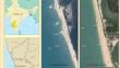
Beach morphology assessment is very important for the sustainable development of beaches and the implementation of beach development activities through management plans. The present study focuses on assessing beach morphology and developing ecosystem-based conservative strategies to control beach erosion and improve beach safety along the two blue-flag certified beaches, Padubidri and Kasarkod, in Karnataka state. The bathymetry of the two beaches varies by gradient changes between the winter and monsoon seasons, and as a result, waves break at a distance of 15–25 m from the shore. The estimated seabed deposition between the winter and monsoon periods of 2020 is 10329 cu m and 59.36 cu m at the Padubidri and Kasarkod beaches, respectively. This study also provides the rate of shoreline change at two beaches along the coast for the period 2018–2022, as measured using geospatial technology and field investigation. The assessment revealed that the Kasarkod and Padubidri coasts experienced maximum erosion of 11.7% and 12.7%, respectively for five years. The projected shoreline changes under the climate change show erosion of 59.12 m on the northern side and accretion of about 16.13 m on the southern side of Kasarkod Beach, whereas on Padubidri Beach, erosion of 40 m on the central part of the beach between 2020 and 2030. The nearshore current magnitude is stronger at the coast of Padubidri than at Kasarkod during the study. The sediment movement from the Kamini River at the Hejamadi endpoint (southern part of Padubidri) shapes the Padubidri beach and causes accretion and erosion during winter and monsoon seasons respectively. However, these beaches are being protected by ecosystem-based conservative strategies such as beach vegetation and dune conservation through the Beach Environment and Aesthetics Management Services (BEAMS) program. Therefore, the assessment of beach morphology and conservation strategies provides a better beach management plan, to control beach erosion, and enhance beach stability.
期刊介绍:
The Journal of Coastal Conservation is a scientific journal for the dissemination of both theoretical and applied research on integrated and sustainable management of the terrestrial, coastal and marine environmental interface.
A thorough understanding of both the physical and the human sciences is important to the study of the spatial patterns and processes observed in terrestrial, coastal and marine systems set in the context of past, present and future social and economic developments. This includes multidisciplinary and integrated knowledge and understanding of: physical geography, coastal geomorphology, sediment dynamics, hydrodynamics, soil science, hydrology, plant and animal ecology, vegetation science, biogeography, landscape ecology, recreation and tourism studies, urban and human ecology, coastal engineering and spatial planning, coastal zone management, and marine resource management.


 分享
分享
 求助内容:
求助内容: 应助结果提醒方式:
 扫码关注我们
